


4.6 km | 7 km-effort

Tous les sentiers balisés d’Europe GUIDE+


FREE GPS app for hiking
 SityTrail
IGN / Geographical institutes
SityTrail World
The world is yours!
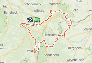
Trail On foot of 37 km to be discovered at North Rhine-Westphalia, Kreis Lippe, Horn-Bad Meinberg. This trail is proposed by SityTrail - itinéraires balisés pédestres.
kombinierte Fahrrad- und Fußwandertour: Zwischen Holzhausen (Station 1) und Leopoldstal (Station 3) nur Fußwandern möglich.
Website: http://www.moorkoeche.de/
 "
data-pinterest-text="Pin it"
data-tweet-text="share on twitter"
data-facebook-share-url="https://www.sitytrail.com/en/trails/3088389-hornxbad-meinberg--themenweg-m-xmoorxkochextourx/?photo=1#lg=1&slide=1"
data-twitter-share-url="https://www.sitytrail.com/en/trails/3088389-hornxbad-meinberg--themenweg-m-xmoorxkochextourx/?photo=1#lg=1&slide=1"
data-googleplus-share-url="https://www.sitytrail.com/en/trails/3088389-hornxbad-meinberg--themenweg-m-xmoorxkochextourx/?photo=1#lg=1&slide=1"
data-pinterest-share-url="https://www.sitytrail.com/en/trails/3088389-hornxbad-meinberg--themenweg-m-xmoorxkochextourx/?photo=1#lg=1&slide=1">
"
data-pinterest-text="Pin it"
data-tweet-text="share on twitter"
data-facebook-share-url="https://www.sitytrail.com/en/trails/3088389-hornxbad-meinberg--themenweg-m-xmoorxkochextourx/?photo=1#lg=1&slide=1"
data-twitter-share-url="https://www.sitytrail.com/en/trails/3088389-hornxbad-meinberg--themenweg-m-xmoorxkochextourx/?photo=1#lg=1&slide=1"
data-googleplus-share-url="https://www.sitytrail.com/en/trails/3088389-hornxbad-meinberg--themenweg-m-xmoorxkochextourx/?photo=1#lg=1&slide=1"
data-pinterest-share-url="https://www.sitytrail.com/en/trails/3088389-hornxbad-meinberg--themenweg-m-xmoorxkochextourx/?photo=1#lg=1&slide=1">
 "
data-pinterest-text="Pin it"
data-tweet-text="share on twitter"
data-facebook-share-url="https://www.sitytrail.com/en/trails/3088389-hornxbad-meinberg--themenweg-m-xmoorxkochextourx/?photo=2#lg=1&slide=2"
data-twitter-share-url="https://www.sitytrail.com/en/trails/3088389-hornxbad-meinberg--themenweg-m-xmoorxkochextourx/?photo=2#lg=1&slide=2"
data-googleplus-share-url="https://www.sitytrail.com/en/trails/3088389-hornxbad-meinberg--themenweg-m-xmoorxkochextourx/?photo=2#lg=1&slide=2"
data-pinterest-share-url="https://www.sitytrail.com/en/trails/3088389-hornxbad-meinberg--themenweg-m-xmoorxkochextourx/?photo=2#lg=1&slide=2">
"
data-pinterest-text="Pin it"
data-tweet-text="share on twitter"
data-facebook-share-url="https://www.sitytrail.com/en/trails/3088389-hornxbad-meinberg--themenweg-m-xmoorxkochextourx/?photo=2#lg=1&slide=2"
data-twitter-share-url="https://www.sitytrail.com/en/trails/3088389-hornxbad-meinberg--themenweg-m-xmoorxkochextourx/?photo=2#lg=1&slide=2"
data-googleplus-share-url="https://www.sitytrail.com/en/trails/3088389-hornxbad-meinberg--themenweg-m-xmoorxkochextourx/?photo=2#lg=1&slide=2"
data-pinterest-share-url="https://www.sitytrail.com/en/trails/3088389-hornxbad-meinberg--themenweg-m-xmoorxkochextourx/?photo=2#lg=1&slide=2">
 "
data-pinterest-text="Pin it"
data-tweet-text="share on twitter"
data-facebook-share-url="https://www.sitytrail.com/en/trails/3088389-hornxbad-meinberg--themenweg-m-xmoorxkochextourx/?photo=3#lg=1&slide=3"
data-twitter-share-url="https://www.sitytrail.com/en/trails/3088389-hornxbad-meinberg--themenweg-m-xmoorxkochextourx/?photo=3#lg=1&slide=3"
data-googleplus-share-url="https://www.sitytrail.com/en/trails/3088389-hornxbad-meinberg--themenweg-m-xmoorxkochextourx/?photo=3#lg=1&slide=3"
data-pinterest-share-url="https://www.sitytrail.com/en/trails/3088389-hornxbad-meinberg--themenweg-m-xmoorxkochextourx/?photo=3#lg=1&slide=3">
"
data-pinterest-text="Pin it"
data-tweet-text="share on twitter"
data-facebook-share-url="https://www.sitytrail.com/en/trails/3088389-hornxbad-meinberg--themenweg-m-xmoorxkochextourx/?photo=3#lg=1&slide=3"
data-twitter-share-url="https://www.sitytrail.com/en/trails/3088389-hornxbad-meinberg--themenweg-m-xmoorxkochextourx/?photo=3#lg=1&slide=3"
data-googleplus-share-url="https://www.sitytrail.com/en/trails/3088389-hornxbad-meinberg--themenweg-m-xmoorxkochextourx/?photo=3#lg=1&slide=3"
data-pinterest-share-url="https://www.sitytrail.com/en/trails/3088389-hornxbad-meinberg--themenweg-m-xmoorxkochextourx/?photo=3#lg=1&slide=3">
 "
data-pinterest-text="Pin it"
data-tweet-text="share on twitter"
data-facebook-share-url="https://www.sitytrail.com/en/trails/3088389-hornxbad-meinberg--themenweg-m-xmoorxkochextourx/?photo=4#lg=1&slide=4"
data-twitter-share-url="https://www.sitytrail.com/en/trails/3088389-hornxbad-meinberg--themenweg-m-xmoorxkochextourx/?photo=4#lg=1&slide=4"
data-googleplus-share-url="https://www.sitytrail.com/en/trails/3088389-hornxbad-meinberg--themenweg-m-xmoorxkochextourx/?photo=4#lg=1&slide=4"
data-pinterest-share-url="https://www.sitytrail.com/en/trails/3088389-hornxbad-meinberg--themenweg-m-xmoorxkochextourx/?photo=4#lg=1&slide=4">
"
data-pinterest-text="Pin it"
data-tweet-text="share on twitter"
data-facebook-share-url="https://www.sitytrail.com/en/trails/3088389-hornxbad-meinberg--themenweg-m-xmoorxkochextourx/?photo=4#lg=1&slide=4"
data-twitter-share-url="https://www.sitytrail.com/en/trails/3088389-hornxbad-meinberg--themenweg-m-xmoorxkochextourx/?photo=4#lg=1&slide=4"
data-googleplus-share-url="https://www.sitytrail.com/en/trails/3088389-hornxbad-meinberg--themenweg-m-xmoorxkochextourx/?photo=4#lg=1&slide=4"
data-pinterest-share-url="https://www.sitytrail.com/en/trails/3088389-hornxbad-meinberg--themenweg-m-xmoorxkochextourx/?photo=4#lg=1&slide=4">
 "
data-pinterest-text="Pin it"
data-tweet-text="share on twitter"
data-facebook-share-url="https://www.sitytrail.com/en/trails/3088389-hornxbad-meinberg--themenweg-m-xmoorxkochextourx/?photo=5#lg=1&slide=5"
data-twitter-share-url="https://www.sitytrail.com/en/trails/3088389-hornxbad-meinberg--themenweg-m-xmoorxkochextourx/?photo=5#lg=1&slide=5"
data-googleplus-share-url="https://www.sitytrail.com/en/trails/3088389-hornxbad-meinberg--themenweg-m-xmoorxkochextourx/?photo=5#lg=1&slide=5"
data-pinterest-share-url="https://www.sitytrail.com/en/trails/3088389-hornxbad-meinberg--themenweg-m-xmoorxkochextourx/?photo=5#lg=1&slide=5">
"
data-pinterest-text="Pin it"
data-tweet-text="share on twitter"
data-facebook-share-url="https://www.sitytrail.com/en/trails/3088389-hornxbad-meinberg--themenweg-m-xmoorxkochextourx/?photo=5#lg=1&slide=5"
data-twitter-share-url="https://www.sitytrail.com/en/trails/3088389-hornxbad-meinberg--themenweg-m-xmoorxkochextourx/?photo=5#lg=1&slide=5"
data-googleplus-share-url="https://www.sitytrail.com/en/trails/3088389-hornxbad-meinberg--themenweg-m-xmoorxkochextourx/?photo=5#lg=1&slide=5"
data-pinterest-share-url="https://www.sitytrail.com/en/trails/3088389-hornxbad-meinberg--themenweg-m-xmoorxkochextourx/?photo=5#lg=1&slide=5">
 "
data-pinterest-text="Pin it"
data-tweet-text="share on twitter"
data-facebook-share-url="https://www.sitytrail.com/en/trails/3088389-hornxbad-meinberg--themenweg-m-xmoorxkochextourx/?photo=6#lg=1&slide=6"
data-twitter-share-url="https://www.sitytrail.com/en/trails/3088389-hornxbad-meinberg--themenweg-m-xmoorxkochextourx/?photo=6#lg=1&slide=6"
data-googleplus-share-url="https://www.sitytrail.com/en/trails/3088389-hornxbad-meinberg--themenweg-m-xmoorxkochextourx/?photo=6#lg=1&slide=6"
data-pinterest-share-url="https://www.sitytrail.com/en/trails/3088389-hornxbad-meinberg--themenweg-m-xmoorxkochextourx/?photo=6#lg=1&slide=6">
"
data-pinterest-text="Pin it"
data-tweet-text="share on twitter"
data-facebook-share-url="https://www.sitytrail.com/en/trails/3088389-hornxbad-meinberg--themenweg-m-xmoorxkochextourx/?photo=6#lg=1&slide=6"
data-twitter-share-url="https://www.sitytrail.com/en/trails/3088389-hornxbad-meinberg--themenweg-m-xmoorxkochextourx/?photo=6#lg=1&slide=6"
data-googleplus-share-url="https://www.sitytrail.com/en/trails/3088389-hornxbad-meinberg--themenweg-m-xmoorxkochextourx/?photo=6#lg=1&slide=6"
data-pinterest-share-url="https://www.sitytrail.com/en/trails/3088389-hornxbad-meinberg--themenweg-m-xmoorxkochextourx/?photo=6#lg=1&slide=6">
 "
data-pinterest-text="Pin it"
data-tweet-text="share on twitter"
data-facebook-share-url="https://www.sitytrail.com/en/trails/3088389-hornxbad-meinberg--themenweg-m-xmoorxkochextourx/?photo=7#lg=1&slide=7"
data-twitter-share-url="https://www.sitytrail.com/en/trails/3088389-hornxbad-meinberg--themenweg-m-xmoorxkochextourx/?photo=7#lg=1&slide=7"
data-googleplus-share-url="https://www.sitytrail.com/en/trails/3088389-hornxbad-meinberg--themenweg-m-xmoorxkochextourx/?photo=7#lg=1&slide=7"
data-pinterest-share-url="https://www.sitytrail.com/en/trails/3088389-hornxbad-meinberg--themenweg-m-xmoorxkochextourx/?photo=7#lg=1&slide=7">
"
data-pinterest-text="Pin it"
data-tweet-text="share on twitter"
data-facebook-share-url="https://www.sitytrail.com/en/trails/3088389-hornxbad-meinberg--themenweg-m-xmoorxkochextourx/?photo=7#lg=1&slide=7"
data-twitter-share-url="https://www.sitytrail.com/en/trails/3088389-hornxbad-meinberg--themenweg-m-xmoorxkochextourx/?photo=7#lg=1&slide=7"
data-googleplus-share-url="https://www.sitytrail.com/en/trails/3088389-hornxbad-meinberg--themenweg-m-xmoorxkochextourx/?photo=7#lg=1&slide=7"
data-pinterest-share-url="https://www.sitytrail.com/en/trails/3088389-hornxbad-meinberg--themenweg-m-xmoorxkochextourx/?photo=7#lg=1&slide=7">
 "
data-pinterest-text="Pin it"
data-tweet-text="share on twitter"
data-facebook-share-url="https://www.sitytrail.com/en/trails/3088389-hornxbad-meinberg--themenweg-m-xmoorxkochextourx/?photo=8#lg=1&slide=8"
data-twitter-share-url="https://www.sitytrail.com/en/trails/3088389-hornxbad-meinberg--themenweg-m-xmoorxkochextourx/?photo=8#lg=1&slide=8"
data-googleplus-share-url="https://www.sitytrail.com/en/trails/3088389-hornxbad-meinberg--themenweg-m-xmoorxkochextourx/?photo=8#lg=1&slide=8"
data-pinterest-share-url="https://www.sitytrail.com/en/trails/3088389-hornxbad-meinberg--themenweg-m-xmoorxkochextourx/?photo=8#lg=1&slide=8">
"
data-pinterest-text="Pin it"
data-tweet-text="share on twitter"
data-facebook-share-url="https://www.sitytrail.com/en/trails/3088389-hornxbad-meinberg--themenweg-m-xmoorxkochextourx/?photo=8#lg=1&slide=8"
data-twitter-share-url="https://www.sitytrail.com/en/trails/3088389-hornxbad-meinberg--themenweg-m-xmoorxkochextourx/?photo=8#lg=1&slide=8"
data-googleplus-share-url="https://www.sitytrail.com/en/trails/3088389-hornxbad-meinberg--themenweg-m-xmoorxkochextourx/?photo=8#lg=1&slide=8"
data-pinterest-share-url="https://www.sitytrail.com/en/trails/3088389-hornxbad-meinberg--themenweg-m-xmoorxkochextourx/?photo=8#lg=1&slide=8">
 "
data-pinterest-text="Pin it"
data-tweet-text="share on twitter"
data-facebook-share-url="https://www.sitytrail.com/en/trails/3088389-hornxbad-meinberg--themenweg-m-xmoorxkochextourx/?photo=9#lg=1&slide=9"
data-twitter-share-url="https://www.sitytrail.com/en/trails/3088389-hornxbad-meinberg--themenweg-m-xmoorxkochextourx/?photo=9#lg=1&slide=9"
data-googleplus-share-url="https://www.sitytrail.com/en/trails/3088389-hornxbad-meinberg--themenweg-m-xmoorxkochextourx/?photo=9#lg=1&slide=9"
data-pinterest-share-url="https://www.sitytrail.com/en/trails/3088389-hornxbad-meinberg--themenweg-m-xmoorxkochextourx/?photo=9#lg=1&slide=9">
"
data-pinterest-text="Pin it"
data-tweet-text="share on twitter"
data-facebook-share-url="https://www.sitytrail.com/en/trails/3088389-hornxbad-meinberg--themenweg-m-xmoorxkochextourx/?photo=9#lg=1&slide=9"
data-twitter-share-url="https://www.sitytrail.com/en/trails/3088389-hornxbad-meinberg--themenweg-m-xmoorxkochextourx/?photo=9#lg=1&slide=9"
data-googleplus-share-url="https://www.sitytrail.com/en/trails/3088389-hornxbad-meinberg--themenweg-m-xmoorxkochextourx/?photo=9#lg=1&slide=9"
data-pinterest-share-url="https://www.sitytrail.com/en/trails/3088389-hornxbad-meinberg--themenweg-m-xmoorxkochextourx/?photo=9#lg=1&slide=9">

On foot
![Trail On foot Horn-Bad Meinberg - Rundwanderweg A4 [Feldrom] - Photo](https://media.geolcdn.com/t/375/260/c3e2fda2-4a4b-4515-b251-ad31aeb36002.jpeg&format=jpg&maxdim=2)
On foot
![Trail On foot Detmold - Rundwanderweg A5 [Berlebeck] - Photo](https://media.geolcdn.com/t/375/260/09e96dc8-2a72-420e-af43-8a0b6d458613.jpeg&format=jpg&maxdim=2)
On foot
On foot
On foot
On foot
![Trail On foot Horn-Bad Meinberg - Rundwanderweg A1 [Holzhausen-Externsteine] - Photo](https://media.geolcdn.com/t/375/260/917c6440-8043-45d4-9c08-101f3367a522.jpeg&format=jpg&maxdim=2)
On foot
![Trail On foot Detmold - Rundwanderweg [Gauseköte] - Photo](https://media.geolcdn.com/t/375/260/b23ec4a7-b5cb-44c3-a014-f0b25ad95715.jpeg&format=jpg&maxdim=2)
On foot
![Trail On foot Horn-Bad Meinberg - Terrainkurweg 9 [Bad Meinberg] - Photo](https://media.geolcdn.com/t/375/260/415dab2e-d838-41c3-b2c1-c698395be57c.jpeg&format=jpg&maxdim=2)
On foot