Trail On foot Merzig - Der Bietzerberger - Photo

Tous les sentiers balisés d’Europe GUIDE+

© OpenStreetMap contributors
Length
Length
17.6 km
Max alt
Max alt
409 m
Uphill gradient
Uphill gradient
373 m
Km-Effort
Km-Effort  
23 km
Min alt
Min alt
194 m
Downhill gradient
Downhill gradient
375 m
Boucle
Boucle
Yes
Signpost
Signpost
Creation date :
2022-02-11 12:53:21.794
Updated on :
2022-02-11 12:53:21.794

(0 Reviews)

On foot
On foot
5h07
Difficulty : Medium

Scan this QR Code to open this trail in the SityTrail application

FREE GPS app for hiking

Logo SityTrail SityTrail

IGN / Geographical institutes

Download SityTrail from the App Store Download SityTrail from Google Play

Logo SityTrail SityTrail World

The world is yours!

Download SityTrail from the App Store Download SityTrail from Google Play Download SityTrail on Huawei AppGallery

About

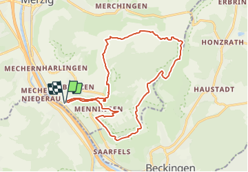
Trail On foot of 17.6 km to be discovered at Saarland, Landkreis Merzig-Wadern, Merzig. This trail is proposed by SityTrail - itinéraires balisés pédestres.

Description

Trail created by Gemeinde Merzig.

Bei der Pflege einer Routenliste ist es von Vorteil, wenn die Relation einen Hinweis auf die Wandergegend enthält. MfG tippeltappel

Symbol: weißes Quadrat mit 3 grünen Bergen und Wiese

Elevation profile

Photos

Positioning

Country:
Germany
Region :
Saarland
Department/Province :
Landkreis Merzig-Wadern
Municipality :
Merzig
Location:
Menningen
Start:(UTM)
329665 ; 5475584 (32U) N.

Trails nearby

Trail On foot Merzig - Wolfsweg - Photo
On foot
GUIDE+

On foot

Easy
Merzig, Saarland, Landkreis Merzig-Wadern, Germany
3.5 km | 4.6 km-effort
1h 2min
No


Close
My subscriptions