


4.3 km | 4.8 km-effort
![Trail On foot Menden - [A8] im Stadtwald Neheim - Photo](https://media.geolcdn.com/t/1900/400/2d66c466-b78f-43e0-bcea-e76d5a8507c4.jpeg&format=pjpeg&maxdim=2)

Tous les sentiers balisés d’Europe GUIDE+


FREE GPS app for hiking
 SityTrail
IGN / Geographical institutes
SityTrail World
The world is yours!
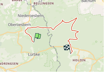
Trail On foot of 11.2 km to be discovered at North Rhine-Westphalia, Märkischer Kreis, Menden. This trail is proposed by SityTrail - itinéraires balisés pédestres.
Trail created by Sauerländischer Gebirgsverein.
![Trail On foot Menden - [A8] im Stadtwald Neheim - Photo 1](https://media.geolcdn.com/t/2048/auto/e62146cf-23cc-4ee1-a5fc-d918de96e138.jpeg&format=jpg&maxdim=0 "Trail On foot Menden - [A8] im Stadtwald Neheim - Photo 1")
![Trail On foot Menden - [A8] im Stadtwald Neheim - Photo 2](https://media.geolcdn.com/t/2048/auto/35a640df-0d90-4814-92d1-64f85a67e0d7.jpeg&format=jpg&maxdim=0 "Trail On foot Menden - [A8] im Stadtwald Neheim - Photo 2")
![Trail On foot Menden - [A8] im Stadtwald Neheim - Photo 3](https://media.geolcdn.com/t/2048/auto/314cb212-7ae0-48c2-bfce-ecb7938b21c1.jpeg&format=jpg&maxdim=0 "Trail On foot Menden - [A8] im Stadtwald Neheim - Photo 3")
![Trail On foot Menden - [A8] im Stadtwald Neheim - Photo 4](https://media.geolcdn.com/t/2048/auto/dac37724-dfb8-4683-839a-db76488a6eae.jpeg&format=jpg&maxdim=0 "Trail On foot Menden - [A8] im Stadtwald Neheim - Photo 4")
![Trail On foot Menden - [A8] im Stadtwald Neheim - Photo 5](https://media.geolcdn.com/t/2048/auto/2d66c466-b78f-43e0-bcea-e76d5a8507c4.jpeg&format=jpg&maxdim=0 "Trail On foot Menden - [A8] im Stadtwald Neheim - Photo 5")
![Trail On foot Menden - [A8] im Stadtwald Neheim - Photo 6](https://media.geolcdn.com/t/2048/auto/bf67ae04-4e37-428c-a857-3764a862e4cd.jpeg&format=jpg&maxdim=0 "Trail On foot Menden - [A8] im Stadtwald Neheim - Photo 6")
![Trail On foot Menden - [A8] im Stadtwald Neheim - Photo 7](https://media.geolcdn.com/t/2048/auto/79ab70c9-750e-4469-ae3c-73cec367c295.jpeg&format=jpg&maxdim=0 "Trail On foot Menden - [A8] im Stadtwald Neheim - Photo 7")
![Trail On foot Menden - [A8] im Stadtwald Neheim - Photo 8](https://media.geolcdn.com/t/2048/auto/bcb0232a-8aaf-4222-a26d-f29d77ff3da4.jpeg&format=jpg&maxdim=0 "Trail On foot Menden - [A8] im Stadtwald Neheim - Photo 8")
![Trail On foot Menden - [A8] im Stadtwald Neheim - Photo 9](https://media.geolcdn.com/t/2048/auto/e05e8e24-a844-4c38-83e1-f29d79e89958.jpeg&format=jpg&maxdim=0 "Trail On foot Menden - [A8] im Stadtwald Neheim - Photo 9")
![Trail On foot Menden - [A8] im Stadtwald Neheim - Photo 10](https://media.geolcdn.com/t/2048/auto/99e82d3c-c290-416f-a17f-8d9f83f3b831.jpeg&format=jpg&maxdim=0 "Trail On foot Menden - [A8] im Stadtwald Neheim - Photo 10")
![Trail On foot Arnsberg - [Dreieck] - Photo](https://media.geolcdn.com/t/375/260/d81aec76-bcc3-4142-a7ee-5c25b52faed3.jpeg&format=jpg&maxdim=2)
On foot
On foot

On foot

On foot
![Trail On foot Menden - [A7] im Stadtwald Neheim - Photo](https://media.geolcdn.com/t/375/260/1df3787c-7ea3-4687-aebc-0b7544580bac.jpeg&format=jpg&maxdim=2)
On foot
![Trail On foot Arnsberg - [Quadrat] Luerwald Rundweg - Photo](https://media.geolcdn.com/t/375/260/956801ea-cad4-4d8d-ac8e-4517bcdfc5db.jpeg&format=jpg&maxdim=2)
On foot
On foot
On foot
On foot