![](/images/other/stat-length.png)
![Trail On foot Blomberg - Nelkenweg - Photo](https://media.geolcdn.com/t/1900/400/e056597a-34b9-457e-b707-58cdbdd1699f.jpeg&format=pjpeg&maxdim=2)
Nelkenweg
SityTrail - itinéraires balisés pédestres
Tous les sentiers balisés d’Europe GUIDE+
![Length](/images/other/stat-length.png)
Length
5.7 km
![Max alt](https://static1.geolcdn.com/siteimages/upload/files/1508320355ic_sort_altitude_max_24dp.png)
Max alt
269 m
![Uphill gradient](https://static1.geolcdn.com/siteimages/upload/files/1508320355ic_sort_den_pos_24dp.png)
Uphill gradient
91 m
![Km-Effort](/images/other/stat-length.png)
Km-Effort
7.1 km
![Min alt](https://static1.geolcdn.com/siteimages/upload/files/1508320355ic_sort_altitude_min_24dp.png)
Min alt
160 m
![Downhill gradient](https://static1.geolcdn.com/siteimages/upload/files/1508320355ic_sort_den_neg_24dp.png)
Downhill gradient
139 m
![Boucle](https://static1.geolcdn.com/siteimages/upload/files/16400158638029165_repeat_loop_refresh_sync_direction_icon.png)
Boucle
No
Signpost
Creation date :
2022-02-11 12:50:44.886
Updated on :
2022-02-11 12:50:44.886
![On foot](https://static1.geolcdn.com/sitytour/trail-icons/100.png)
1h36
Difficulty : Easy
![Scan this QR Code to open this trail in the SityTrail application](https://capi.geolives.com/qq0zvz2zws4bq2lad0pu/sitytour/trails/3088137/qr.png?size=200)
FREE GPS app for hiking
About
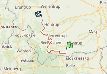
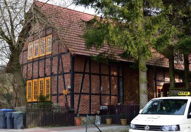
Trail On foot of 5.7 km to be discovered at North Rhine-Westphalia, Kreis Lippe, Blomberg. This trail is proposed by SityTrail - itinéraires balisés pédestres.
Description
Trail created by Naturpark Teutoburger Wald / Eggegebirge.
Symbol: Weißes N im weißem Kreis auf schwarzem Untergrund
Positioning
Country:
Germany
Region :
North Rhine-Westphalia
Department/Province :
Kreis Lippe
Municipality :
Blomberg
Location:
Unknown
Start:(Dec)
Start:(UTM)
503153 ; 5750819 (32U) N.
Comments
Trails nearby
![Trail On foot Horn-Bad Meinberg - Zugangsweg Hermannshöhen - Horn-Bad Meinberg - Photo](https://media.geolcdn.com/t/375/260/481dc017-712c-4a92-87e6-77c38ebad9f4.jpeg&format=jpg&maxdim=2)
![On foot On foot](https://static1.geolcdn.com/sitytour/trail-icons/100.png)
Zugangsweg Hermannshöhen - Horn-Bad Meinberg
On foot
Easy
Horn-Bad Meinberg,
North Rhine-Westphalia,
Kreis Lippe,
Germany
![](/images/other/stat-length.png)
5.5 km | 6.2 km-effort
1h 25min
![](https://static1.geolcdn.com/siteimages/upload/files/16400158638029165_repeat_loop_refresh_sync_direction_icon.png)
No
![Trail On foot Horn-Bad Meinberg - Terrainkurweg 9 [Bad Meinberg] - Photo](https://media.geolcdn.com/t/375/260/415dab2e-d838-41c3-b2c1-c698395be57c.jpeg&format=jpg&maxdim=2)
![On foot On foot](https://static1.geolcdn.com/sitytour/trail-icons/100.png)
Terrainkurweg 9 [Bad Meinberg]
On foot
Easy
Horn-Bad Meinberg,
North Rhine-Westphalia,
Kreis Lippe,
Germany
![](/images/other/stat-length.png)
5.5 km | 7.1 km-effort
1h 36min
![](https://static1.geolcdn.com/siteimages/upload/files/16400158638029165_repeat_loop_refresh_sync_direction_icon.png)
Yes
![Trail On foot Horn-Bad Meinberg - Terrainkurweg 5 [Bad Meinberg] - Photo](https://media.geolcdn.com/t/375/260/c6c364b8-a98c-4894-be50-01092c15d2a2.jpeg&format=jpg&maxdim=2)
![On foot On foot](https://static1.geolcdn.com/sitytour/trail-icons/100.png)
Terrainkurweg 5 [Bad Meinberg]
On foot
Easy
Horn-Bad Meinberg,
North Rhine-Westphalia,
Kreis Lippe,
Germany
![](/images/other/stat-length.png)
3.3 km | 3.9 km-effort
53min
![](https://static1.geolcdn.com/siteimages/upload/files/16400158638029165_repeat_loop_refresh_sync_direction_icon.png)
Yes
![Trail On foot Horn-Bad Meinberg - Terrainkurweg 4 [Bad Meinberg] - Photo](https://media.geolcdn.com/t/375/260/17855ced-c021-469c-b31b-b1f4ceaf95e0.jpeg&format=jpg&maxdim=2)
![On foot On foot](https://static1.geolcdn.com/sitytour/trail-icons/100.png)
Terrainkurweg 4 [Bad Meinberg]
On foot
Easy
Horn-Bad Meinberg,
North Rhine-Westphalia,
Kreis Lippe,
Germany
![](/images/other/stat-length.png)
5.2 km | 6.3 km-effort
1h 26min
![](https://static1.geolcdn.com/siteimages/upload/files/16400158638029165_repeat_loop_refresh_sync_direction_icon.png)
Yes
![Trail On foot Horn-Bad Meinberg - Ruhe - Wanderweg Norderteich [Bad Meinberg] (VitalWanderWelt) - Photo](https://media.geolcdn.com/t/375/260/62948217-785e-4bf8-a3a7-9c99707dba50.jpeg&format=jpg&maxdim=2)
![On foot On foot](https://static1.geolcdn.com/sitytour/trail-icons/100.png)
Ruhe - Wanderweg Norderteich [Bad Meinberg] (VitalWanderWelt)
On foot
Easy
Horn-Bad Meinberg,
North Rhine-Westphalia,
Kreis Lippe,
Germany
![](/images/other/stat-length.png)
5 km | 6 km-effort
1h 22min
![](https://static1.geolcdn.com/siteimages/upload/files/16400158638029165_repeat_loop_refresh_sync_direction_icon.png)
No
![Trail On foot Horn-Bad Meinberg - Norderteich-Rundwanderweg [Billerbeck / Entenkrug] - Photo](https://media.geolcdn.com/t/375/260/0fd9e1b3-fa56-43c1-84a2-bd9d47765815.jpeg&format=jpg&maxdim=2)
![On foot On foot](https://static1.geolcdn.com/sitytour/trail-icons/100.png)
Norderteich-Rundwanderweg [Billerbeck / Entenkrug]
On foot
Easy
Horn-Bad Meinberg,
North Rhine-Westphalia,
Kreis Lippe,
Germany
![](/images/other/stat-length.png)
3.4 km | 4 km-effort
54min
![](https://static1.geolcdn.com/siteimages/upload/files/16400158638029165_repeat_loop_refresh_sync_direction_icon.png)
No
![Trail On foot Horn-Bad Meinberg - DSV nordic aktiv - rote Route [Bad Meinberg] (Nordic Walking) - Photo](https://media.geolcdn.com/t/375/260/415dab2e-d838-41c3-b2c1-c698395be57c.jpeg&format=jpg&maxdim=2)
![On foot On foot](https://static1.geolcdn.com/sitytour/trail-icons/100.png)
DSV nordic aktiv - rote Route [Bad Meinberg] (Nordic Walking)
On foot
Easy
Horn-Bad Meinberg,
North Rhine-Westphalia,
Kreis Lippe,
Germany
![](/images/other/stat-length.png)
3.6 km | 4.8 km-effort
1h 5min
![](https://static1.geolcdn.com/siteimages/upload/files/16400158638029165_repeat_loop_refresh_sync_direction_icon.png)
No
![Trail On foot Blomberg - Nelkenweg Zubringer 8 - Photo](https://media.geolcdn.com/t/375/260/84d6a1fd-5de9-4568-849f-24c944a6105f.jpeg&format=jpg&maxdim=2)
![On foot On foot](https://static1.geolcdn.com/sitytour/trail-icons/100.png)
Nelkenweg Zubringer 8
On foot
Easy
Blomberg,
North Rhine-Westphalia,
Kreis Lippe,
Germany
![](/images/other/stat-length.png)
6.4 km | 7.7 km-effort
1h 44min
![](https://static1.geolcdn.com/siteimages/upload/files/16400158638029165_repeat_loop_refresh_sync_direction_icon.png)
No
![Trail On foot Blomberg - Nelkenweg Zubringer 5 - Photo](https://media.geolcdn.com/t/375/260/f07e9bab-4fc7-4971-a612-8fed9efc2014.jpeg&format=jpg&maxdim=2)
![On foot On foot](https://static1.geolcdn.com/sitytour/trail-icons/100.png)
Nelkenweg Zubringer 5
On foot
Easy
Blomberg,
North Rhine-Westphalia,
Kreis Lippe,
Germany
![](/images/other/stat-length.png)
6.1 km | 7.3 km-effort
1h 39min
![](https://static1.geolcdn.com/siteimages/upload/files/16400158638029165_repeat_loop_refresh_sync_direction_icon.png)
No