![](/images/other/stat-length.png)
![Trail On foot Gernsbach - Rundweg Nr. 1 - Grünhütten-Rundweg - Photo](https://media.geolcdn.com/t/1900/400/7fcc4a4c-c1cf-45e1-a893-e8b90459f9e9.jpeg&format=pjpeg&maxdim=2)
Rundweg Nr. 1 - Grünhütten-Rundweg
SityTrail - itinéraires balisés pédestres
Tous les sentiers balisés d’Europe GUIDE+
![Length](/images/other/stat-length.png)
Length
8.3 km
![Max alt](https://static1.geolcdn.com/siteimages/upload/files/1508320355ic_sort_altitude_max_24dp.png)
Max alt
927 m
![Uphill gradient](https://static1.geolcdn.com/siteimages/upload/files/1508320355ic_sort_den_pos_24dp.png)
Uphill gradient
124 m
![Km-Effort](/images/other/stat-length.png)
Km-Effort
10 km
![Min alt](https://static1.geolcdn.com/siteimages/upload/files/1508320355ic_sort_altitude_min_24dp.png)
Min alt
877 m
![Downhill gradient](https://static1.geolcdn.com/siteimages/upload/files/1508320355ic_sort_den_neg_24dp.png)
Downhill gradient
124 m
![Boucle](https://static1.geolcdn.com/siteimages/upload/files/16400158638029165_repeat_loop_refresh_sync_direction_icon.png)
Boucle
Yes
Signpost
Creation date :
2022-02-11 12:50:36.92
Updated on :
2022-02-11 12:50:36.92
![On foot](https://static1.geolcdn.com/sitytour/trail-icons/100.png)
2h15
Difficulty : Easy
![Scan this QR Code to open this trail in the SityTrail application](https://capi.geolives.com/qq0zvz2zws4bq2lad0pu/sitytour/trails/3088123/qr.png?size=200)
FREE GPS app for hiking
About
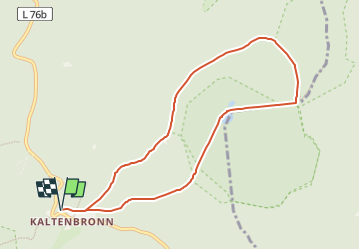
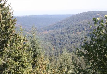
Trail On foot of 8.3 km to be discovered at Baden-Württemberg, Landkreis Rastatt, Gernsbach. This trail is proposed by SityTrail - itinéraires balisés pédestres.
Description
Trail created by Infozentrum Kaltenbronn.
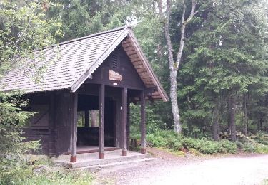
Symbol: Weißes Quadrat, mit dünner lila Linie umrahmt. Große schwarze 1 in der Mitte, darüber klein "Rundweg", darunter "Kaltenbronn"
Positioning
Country:
Germany
Region :
Baden-Württemberg
Department/Province :
Landkreis Rastatt
Municipality :
Gernsbach
Location:
Reichental
Start:(Dec)
Start:(UTM)
458087 ; 5395117 (32U) N.
Comments
Trails nearby
![Trail On foot Gernsbach - Orgelfelsenhaus-Teufelsmühle - Photo](https://media.geolcdn.com/t/375/260/e9d5d20a-a27c-4330-84a4-dc94b22c0093.jpeg&format=jpg&maxdim=2)
![On foot On foot](https://static1.geolcdn.com/sitytour/trail-icons/100.png)
Orgelfelsenhaus-Teufelsmühle
On foot
Easy
Gernsbach,
Baden-Württemberg,
Landkreis Rastatt,
Germany
![](/images/other/stat-length.png)
3.9 km | 6.3 km-effort
1h 25min
![](https://static1.geolcdn.com/siteimages/upload/files/16400158638029165_repeat_loop_refresh_sync_direction_icon.png)
No
![Trail On foot Enzklösterle - Enzklösterle-Gompelscheuer Flößerhaus - Photo](https://media.geolcdn.com/t/375/260/d60f591b-c3af-4633-967f-ac9f94433455.jpeg&format=jpg&maxdim=2)
![On foot On foot](https://static1.geolcdn.com/sitytour/trail-icons/100.png)
Enzklösterle-Gompelscheuer Flößerhaus
On foot
Easy
Enzklösterle,
Baden-Württemberg,
Landkreis Calw,
Germany
![](/images/other/stat-length.png)
4.8 km | 7.2 km-effort
1h 37min
![](https://static1.geolcdn.com/siteimages/upload/files/16400158638029165_repeat_loop_refresh_sync_direction_icon.png)
No
![Trail On foot Enzklösterle - Enzklösterle - Zwerenberg - Photo](https://media.geolcdn.com/t/375/260/d60f591b-c3af-4633-967f-ac9f94433455.jpeg&format=jpg&maxdim=2)
![On foot On foot](https://static1.geolcdn.com/sitytour/trail-icons/100.png)
Enzklösterle - Zwerenberg
On foot
Easy
Enzklösterle,
Baden-Württemberg,
Landkreis Calw,
Germany
![](/images/other/stat-length.png)
10.4 km | 15.5 km-effort
3h 31min
![](https://static1.geolcdn.com/siteimages/upload/files/16400158638029165_repeat_loop_refresh_sync_direction_icon.png)
No
![Trail On foot Gernsbach - Naturerlebnisweg Kaltenbronn - Photo](https://media.geolcdn.com/t/375/260/5abeb0a5-14eb-4923-a9ca-7d878e1f579c.jpeg&format=jpg&maxdim=2)
![On foot On foot](https://static1.geolcdn.com/sitytour/trail-icons/100.png)
Naturerlebnisweg Kaltenbronn
On foot
Easy
Gernsbach,
Baden-Württemberg,
Landkreis Rastatt,
Germany
![](/images/other/stat-length.png)
3.7 km | 4.2 km-effort
57min
![](https://static1.geolcdn.com/siteimages/upload/files/16400158638029165_repeat_loop_refresh_sync_direction_icon.png)
No
![Trail Other activity Gernsbach - Kaltenbronn - Wilde - Gruenhuette - Photo](https://media.geolcdn.com/t/375/260/ext.jpg?maxdim=2&url=https%3A%2F%2Fservices.sitytrail.com%2FGeolivesWS%2FDownloadMedia.ashx%3FTrailID%3D613348%26Media%3Dfix__20160812124451.jpg)
![Other activity Other activity](https://static1.geolcdn.com/sitytour/trail-icons/900.png)
Kaltenbronn - Wilde - Gruenhuette
Other activity
Very easy
Gernsbach,
Baden-Württemberg,
Landkreis Rastatt,
Germany
![](/images/other/stat-length.png)
12.7 km | 15.7 km-effort
4h 6min
![](https://static1.geolcdn.com/siteimages/upload/files/16400158638029165_repeat_loop_refresh_sync_direction_icon.png)
Yes