![](/images/other/stat-length.png)
![Trail On foot Unknown - Rundwanderweg Kruppwald A1 - Photo](https://media.geolcdn.com/t/1900/400/e661952d-36ee-486c-900a-be0fa3c30401.jpeg&format=pjpeg&maxdim=2)
Rundwanderweg Kruppwald A1
SityTrail - itinéraires balisés pédestres
Tous les sentiers balisés d’Europe GUIDE+
![Length](/images/other/stat-length.png)
Length
3.7 km
![Max alt](https://static1.geolcdn.com/siteimages/upload/files/1508320355ic_sort_altitude_max_24dp.png)
Max alt
147 m
![Uphill gradient](https://static1.geolcdn.com/siteimages/upload/files/1508320355ic_sort_den_pos_24dp.png)
Uphill gradient
113 m
![Km-Effort](/images/other/stat-length.png)
Km-Effort
5.2 km
![Min alt](https://static1.geolcdn.com/siteimages/upload/files/1508320355ic_sort_altitude_min_24dp.png)
Min alt
63 m
![Downhill gradient](https://static1.geolcdn.com/siteimages/upload/files/1508320355ic_sort_den_neg_24dp.png)
Downhill gradient
120 m
![Boucle](https://static1.geolcdn.com/siteimages/upload/files/16400158638029165_repeat_loop_refresh_sync_direction_icon.png)
Boucle
Yes
Signpost
Creation date :
2022-02-11 12:47:09.038
Updated on :
2022-02-11 12:47:09.038
![On foot](https://static1.geolcdn.com/sitytour/trail-icons/100.png)
1h10
Difficulty : Easy
![Scan this QR Code to open this trail in the SityTrail application](https://capi.geolives.com/qq0zvz2zws4bq2lad0pu/sitytour/trails/3087874/qr.png?size=200)
FREE GPS app for hiking
About
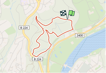
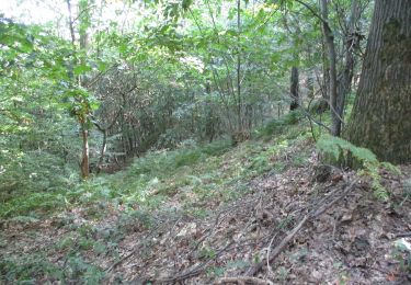
Trail On foot of 3.7 km to be discovered at North Rhine-Westphalia, Essen, Unknown. This trail is proposed by SityTrail - itinéraires balisés pédestres.
Description
Trail created by Sauerländischer Gebirgsverein.
Symbol: weißer Schriftzug A1 auf schwarzem Grund
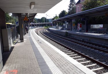
Positioning
Country:
Germany
Region :
North Rhine-Westphalia
Department/Province :
Essen
Municipality :
Unknown
Location:
Stadtbezirk IX
Start:(Dec)
Start:(UTM)
361025 ; 5696819 (32U) N.
Comments
Trails nearby
![Trail On foot Unknown - Kettwiger Panoramasteig - Photo](https://media.geolcdn.com/t/375/260/c4c1ff8e-1ed2-4bc5-830a-9183bb44de95.jpeg&format=jpg&maxdim=2)
![On foot On foot](https://static1.geolcdn.com/sitytour/trail-icons/100.png)
Kettwiger Panoramasteig
On foot
Very difficult
Unknown,
North Rhine-Westphalia,
Essen,
Germany
![](/images/other/stat-length.png)
34 km | 45 km-effort
10h 7min
![](https://static1.geolcdn.com/siteimages/upload/files/16400158638029165_repeat_loop_refresh_sync_direction_icon.png)
Yes
![Trail On foot Unknown - Pilgerweg Heidhausen - Essen - Photo](https://media.geolcdn.com/t/375/260/982c6e32-3d1c-4d42-a67d-562ea32f65b9.jpeg&format=jpg&maxdim=2)
![On foot On foot](https://static1.geolcdn.com/sitytour/trail-icons/100.png)
Pilgerweg Heidhausen - Essen
On foot
Easy
Unknown,
North Rhine-Westphalia,
Essen,
Germany
![](/images/other/stat-length.png)
7.5 km | 9.2 km-effort
2h 5min
![](https://static1.geolcdn.com/siteimages/upload/files/16400158638029165_repeat_loop_refresh_sync_direction_icon.png)
No
![Trail On foot Unknown - BaldeneySteig - Photo](https://media.geolcdn.com/t/375/260/6b304d79-4029-4f4c-bae2-94841998b36b.jpeg&format=jpg&maxdim=2)
![On foot On foot](https://static1.geolcdn.com/sitytour/trail-icons/100.png)
BaldeneySteig
On foot
Medium
Unknown,
North Rhine-Westphalia,
Essen,
Germany
![](/images/other/stat-length.png)
16.4 km | 21 km-effort
4h 46min
![](https://static1.geolcdn.com/siteimages/upload/files/16400158638029165_repeat_loop_refresh_sync_direction_icon.png)
No
![Trail On foot Unknown - Naturfreundeweg Ruhrtalhaus - Kettwig - Tönisheide - Photo](https://media.geolcdn.com/t/375/260/882e315b-2a5a-42a9-8c87-cfa647c78e94.jpeg&format=jpg&maxdim=2)
![On foot On foot](https://static1.geolcdn.com/sitytour/trail-icons/100.png)
Naturfreundeweg Ruhrtalhaus - Kettwig - Tönisheide
On foot
Medium
Unknown,
North Rhine-Westphalia,
Mülheim an der Ruhr,
Germany
![](/images/other/stat-length.png)
24 km | 31 km-effort
7h 0min
![](https://static1.geolcdn.com/siteimages/upload/files/16400158638029165_repeat_loop_refresh_sync_direction_icon.png)
No
![Trail On foot Unknown - Langenhorst Rundweg A2 - Photo](https://media.geolcdn.com/t/375/260/37de7098-65d5-4f9b-8826-39875ca85d50.jpeg&format=jpg&maxdim=2)
![On foot On foot](https://static1.geolcdn.com/sitytour/trail-icons/100.png)
Langenhorst Rundweg A2
On foot
Easy
Unknown,
North Rhine-Westphalia,
Essen,
Germany
![](/images/other/stat-length.png)
5.2 km | 7.4 km-effort
1h 40min
![](https://static1.geolcdn.com/siteimages/upload/files/16400158638029165_repeat_loop_refresh_sync_direction_icon.png)
No
![Trail On foot Unknown - Naturfreundeweg Ruhrtalhaus - Werden - Tönisheide - Photo](https://media.geolcdn.com/t/375/260/8893a24b-e061-4946-8526-b0b57bfb0c41.jpeg&format=jpg&maxdim=2)
![On foot On foot](https://static1.geolcdn.com/sitytour/trail-icons/100.png)
Naturfreundeweg Ruhrtalhaus - Werden - Tönisheide
On foot
Easy
Unknown,
North Rhine-Westphalia,
Essen,
Germany
![](/images/other/stat-length.png)
7.8 km | 10.1 km-effort
2h 17min
![](https://static1.geolcdn.com/siteimages/upload/files/16400158638029165_repeat_loop_refresh_sync_direction_icon.png)
No
![Trail On foot Unknown - Rundwanderweg Heissiwald A2 - Photo](https://media.geolcdn.com/t/375/260/c6a2cb87-ea19-42a9-923c-74ebad52d330.jpeg&format=jpg&maxdim=2)
![On foot On foot](https://static1.geolcdn.com/sitytour/trail-icons/100.png)
Rundwanderweg Heissiwald A2
On foot
Easy
Unknown,
North Rhine-Westphalia,
Essen,
Germany
![](/images/other/stat-length.png)
3.3 km | 4.5 km-effort
1h 0min
![](https://static1.geolcdn.com/siteimages/upload/files/16400158638029165_repeat_loop_refresh_sync_direction_icon.png)
Yes
![Trail On foot Unknown - Rundweg A2 (Schellenberger Wald) - Photo](https://media.geolcdn.com/t/375/260/504d63b2-c697-414a-bdb7-972e481d5cb1.jpeg&format=jpg&maxdim=2)
![On foot On foot](https://static1.geolcdn.com/sitytour/trail-icons/100.png)
Rundweg A2 (Schellenberger Wald)
On foot
Easy
Unknown,
North Rhine-Westphalia,
Essen,
Germany
![](/images/other/stat-length.png)
5.2 km | 6.6 km-effort
1h 29min
![](https://static1.geolcdn.com/siteimages/upload/files/16400158638029165_repeat_loop_refresh_sync_direction_icon.png)
Yes
![Trail On foot Unknown - Rundweg A3 (Baldeney) - Photo](https://media.geolcdn.com/t/375/260/7b945514-5838-4261-a56f-73600c65b4bb.jpeg&format=jpg&maxdim=2)
![On foot On foot](https://static1.geolcdn.com/sitytour/trail-icons/100.png)
Rundweg A3 (Baldeney)
On foot
Easy
Unknown,
North Rhine-Westphalia,
Essen,
Germany
![](/images/other/stat-length.png)
3.8 km | 5.5 km-effort
1h 14min
![](https://static1.geolcdn.com/siteimages/upload/files/16400158638029165_repeat_loop_refresh_sync_direction_icon.png)
No