![](/images/other/stat-length.png)
![Trail On foot Korbach - Medebacher Bergweg - Photo](https://media.geolcdn.com/t/1900/400/ext.pjpeg?maxdim=2&url=https%3A%2F%2Fmedia.geolcdn.com%2Ff%2F6cadc544-9d2a-49e9-b608-9db8b08785b5.jpeg)
Medebacher Bergweg
SityTrail - itinéraires balisés pédestres
Tous les sentiers balisés d’Europe PRO
![Length](/images/other/stat-length.png)
Length
11.9 km
![Max alt](https://static1.geolcdn.com/siteimages/upload/files/1508320355ic_sort_altitude_max_24dp.png)
Max alt
582 m
![Uphill gradient](https://static1.geolcdn.com/siteimages/upload/files/1508320355ic_sort_den_pos_24dp.png)
Uphill gradient
242 m
![Km-Effort](/images/other/stat-length.png)
Km-Effort
15.4 km
![Min alt](https://static1.geolcdn.com/siteimages/upload/files/1508320355ic_sort_altitude_min_24dp.png)
Min alt
384 m
![Downhill gradient](https://static1.geolcdn.com/siteimages/upload/files/1508320355ic_sort_den_neg_24dp.png)
Downhill gradient
333 m
![Boucle](https://static1.geolcdn.com/siteimages/upload/files/16400158638029165_repeat_loop_refresh_sync_direction_icon.png)
Boucle
No
Signpost
Creation date :
2022-02-11 12:47:04.54
Updated on :
2022-02-11 12:47:04.54
![On foot](https://static1.geolcdn.com/sitytour/trail-icons/100.png)
3h29
Difficulty : Easy
![Scan this QR Code to open this trail in the SityTrail application](https://capi.geolives.com/qq0zvz2zws4bq2lad0pu/sitytour/trails/3087865/qr.png?size=200)
FREE GPS app for hiking
About
Trail On foot of 11.9 km to be discovered at Hesse, Landkreis Waldeck-Frankenberg, Korbach. This trail is proposed by SityTrail - itinéraires balisés pédestres.
Description
Trail created by Touristik GmbH Medebach.
Dieser Weg ist OHNE Wanderzeichen - Prüfen, ob es diesen noch gibt
Symbol: Rot-weißes Kreuz auf beigem Grund mit rotem Rahmen
Positioning
Country:
Germany
Region :
Hesse
Department/Province :
Landkreis Waldeck-Frankenberg
Municipality :
Korbach
Location:
Unknown
Start:(Dec)
Start:(UTM)
480985 ; 5677669 (32U) N.
Comments
Trails nearby
![Trail On foot Willingen (Upland) - Hessenweg 6, Abschnitt Welleringhausen - Korbach - Photo](https://media.geolcdn.com/t/375/260/ext.jpg?maxdim=2&url=https%3A%2F%2Fmedia.geolcdn.com%2Ff%2F612c1459-72bd-4150-b223-99b96c8f638e.jpeg)
![On foot On foot](https://static1.geolcdn.com/sitytour/trail-icons/100.png)
Hessenweg 6, Abschnitt Welleringhausen - Korbach
On foot
Easy
Willingen (Upland),
Hesse,
Landkreis Waldeck-Frankenberg,
Germany
![](/images/other/stat-length.png)
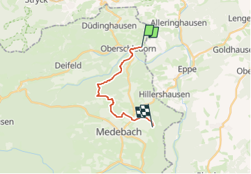
12.7 km | 15.8 km-effort
3h 35min
![](https://static1.geolcdn.com/siteimages/upload/files/16400158638029165_repeat_loop_refresh_sync_direction_icon.png)
No
![Trail On foot Medebach - Medebach - Oberschledorn V - Photo](https://media.geolcdn.com/t/375/260/ext.jpg?maxdim=2&url=https%3A%2F%2Fmedia.geolcdn.com%2Ff%2F60199da6-49fc-4277-b5b5-2bc3a68d52e6.jpeg)
![On foot On foot](https://static1.geolcdn.com/sitytour/trail-icons/100.png)
Medebach - Oberschledorn V
On foot
Easy
Medebach,
North Rhine-Westphalia,
Hochsauerlandkreis,
Germany
![](/images/other/stat-length.png)
7.5 km | 10.3 km-effort
2h 20min
![](https://static1.geolcdn.com/siteimages/upload/files/16400158638029165_repeat_loop_refresh_sync_direction_icon.png)
No
![Trail On foot Medebach - Oberschledorn Rundweg O3 Hirschtalweg - Photo](https://media.geolcdn.com/t/375/260/ext.jpg?maxdim=2&url=https%3A%2F%2Fmedia.geolcdn.com%2Ff%2F60199da6-49fc-4277-b5b5-2bc3a68d52e6.jpeg)
![On foot On foot](https://static1.geolcdn.com/sitytour/trail-icons/100.png)
Oberschledorn Rundweg O3 Hirschtalweg
On foot
Easy
Medebach,
North Rhine-Westphalia,
Hochsauerlandkreis,
Germany
![](/images/other/stat-length.png)
6.7 km | 9.1 km-effort
2h 4min
![](https://static1.geolcdn.com/siteimages/upload/files/16400158638029165_repeat_loop_refresh_sync_direction_icon.png)
Yes
![Trail On foot Medebach - Oberschledorn Rundweg O4 Hallebachtagweg - Photo](https://media.geolcdn.com/t/375/260/ext.jpg?maxdim=2&url=https%3A%2F%2Fmedia.geolcdn.com%2Ff%2F60199da6-49fc-4277-b5b5-2bc3a68d52e6.jpeg)
![On foot On foot](https://static1.geolcdn.com/sitytour/trail-icons/100.png)
Oberschledorn Rundweg O4 Hallebachtagweg
On foot
Easy
Medebach,
North Rhine-Westphalia,
Hochsauerlandkreis,
Germany
![](/images/other/stat-length.png)
6.6 km | 8.8 km-effort
1h 59min
![](https://static1.geolcdn.com/siteimages/upload/files/16400158638029165_repeat_loop_refresh_sync_direction_icon.png)
Yes
![Trail On foot Medebach - Oberschledorn Rundweg O5 Wilde-Ah-Weg - Photo](https://media.geolcdn.com/t/375/260/ext.jpg?maxdim=2&url=https%3A%2F%2Fmedia.geolcdn.com%2Ff%2F60199da6-49fc-4277-b5b5-2bc3a68d52e6.jpeg)
![On foot On foot](https://static1.geolcdn.com/sitytour/trail-icons/100.png)
Oberschledorn Rundweg O5 Wilde-Ah-Weg
On foot
Easy
Medebach,
North Rhine-Westphalia,
Hochsauerlandkreis,
Germany
![](/images/other/stat-length.png)
6.2 km | 8.2 km-effort
1h 52min
![](https://static1.geolcdn.com/siteimages/upload/files/16400158638029165_repeat_loop_refresh_sync_direction_icon.png)
Yes
![Trail On foot Medebach - Oberschledorn Rundweg O1 Rohwiesenweg - Photo](https://media.geolcdn.com/t/375/260/ext.jpg?maxdim=2&url=https%3A%2F%2Fmedia.geolcdn.com%2Ff%2F60199da6-49fc-4277-b5b5-2bc3a68d52e6.jpeg)
![On foot On foot](https://static1.geolcdn.com/sitytour/trail-icons/100.png)
Oberschledorn Rundweg O1 Rohwiesenweg
On foot
Easy
Medebach,
North Rhine-Westphalia,
Hochsauerlandkreis,
Germany
![](/images/other/stat-length.png)
4.7 km | 5.9 km-effort
1h 21min
![](https://static1.geolcdn.com/siteimages/upload/files/16400158638029165_repeat_loop_refresh_sync_direction_icon.png)
Yes