


13.3 km | 17.7 km-effort
![Trail On foot Unknown - S 21 Regensburg-Neuprüll - Unterirading [Walba] (Grünes Rechteck) - Photo](https://media.geolcdn.com/t/1900/400/f7ecf863-2b2d-4886-b112-06f87ea34e11.jpeg&format=pjpeg&maxdim=2)

Tous les sentiers balisés d’Europe GUIDE+


FREE GPS app for hiking
 SityTrail
IGN / Geographical institutes
SityTrail World
The world is yours!
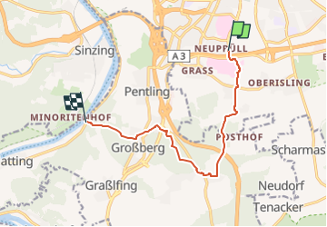
Trail On foot of 9.1 km to be discovered at Bavaria, Regensburg. This trail is proposed by SityTrail - itinéraires balisés pédestres.
Trail created by Waldverein Regensburg.
Symbol: Grünes Rechteck auf weißem Grund
![Trail On foot Unknown - S 21 Regensburg-Neuprüll - Unterirading [Walba] (Grünes Rechteck) - Photo 1](https://media.geolcdn.com/t/2048/auto/8f57e7a8-3b49-4ee1-88f7-e1ae46e9f878.jpeg&format=jpg&maxdim=0 "Trail On foot Unknown - S 21 Regensburg-Neuprüll - Unterirading [Walba] (Grünes Rechteck) - Photo 1")
![Trail On foot Unknown - S 21 Regensburg-Neuprüll - Unterirading [Walba] (Grünes Rechteck) - Photo 2](https://media.geolcdn.com/t/2048/auto/032bf50e-1c98-49f8-9882-89406615f80a.jpeg&format=jpg&maxdim=0 "Trail On foot Unknown - S 21 Regensburg-Neuprüll - Unterirading [Walba] (Grünes Rechteck) - Photo 2")
![Trail On foot Unknown - S 21 Regensburg-Neuprüll - Unterirading [Walba] (Grünes Rechteck) - Photo 3](https://media.geolcdn.com/t/2048/auto/76478ac4-4af3-4557-8245-c9f2949ac432.jpeg&format=jpg&maxdim=0 "Trail On foot Unknown - S 21 Regensburg-Neuprüll - Unterirading [Walba] (Grünes Rechteck) - Photo 3")
![Trail On foot Unknown - S 21 Regensburg-Neuprüll - Unterirading [Walba] (Grünes Rechteck) - Photo 4](https://media.geolcdn.com/t/2048/auto/03af6203-9f0b-499b-a1a2-6a0fa5fbf7c1.jpeg&format=jpg&maxdim=0 "Trail On foot Unknown - S 21 Regensburg-Neuprüll - Unterirading [Walba] (Grünes Rechteck) - Photo 4")
![Trail On foot Unknown - S 21 Regensburg-Neuprüll - Unterirading [Walba] (Grünes Rechteck) - Photo 5](https://media.geolcdn.com/t/2048/auto/b42458e1-5326-4c9b-9d81-70a4f6a804d7.jpeg&format=jpg&maxdim=0 "Trail On foot Unknown - S 21 Regensburg-Neuprüll - Unterirading [Walba] (Grünes Rechteck) - Photo 5")
![Trail On foot Unknown - S 21 Regensburg-Neuprüll - Unterirading [Walba] (Grünes Rechteck) - Photo 6](https://media.geolcdn.com/t/2048/auto/f96c3f4e-7e8e-4f92-92a0-5d0e54004354.jpeg&format=jpg&maxdim=0 "Trail On foot Unknown - S 21 Regensburg-Neuprüll - Unterirading [Walba] (Grünes Rechteck) - Photo 6")
![Trail On foot Unknown - S 21 Regensburg-Neuprüll - Unterirading [Walba] (Grünes Rechteck) - Photo 7](https://media.geolcdn.com/t/2048/auto/f9bc485c-1d4e-400a-8ed0-bddcfaf40250.jpeg&format=jpg&maxdim=0 "Trail On foot Unknown - S 21 Regensburg-Neuprüll - Unterirading [Walba] (Grünes Rechteck) - Photo 7")
![Trail On foot Unknown - S 21 Regensburg-Neuprüll - Unterirading [Walba] (Grünes Rechteck) - Photo 8](https://media.geolcdn.com/t/2048/auto/7f8bbe25-2a1b-44f4-a784-91c292ef29e4.jpeg&format=jpg&maxdim=0 "Trail On foot Unknown - S 21 Regensburg-Neuprüll - Unterirading [Walba] (Grünes Rechteck) - Photo 8")
![Trail On foot Unknown - S 21 Regensburg-Neuprüll - Unterirading [Walba] (Grünes Rechteck) - Photo 9](https://media.geolcdn.com/t/2048/auto/81f267c5-b53b-4c4e-b86a-f20025f30912.jpeg&format=jpg&maxdim=0 "Trail On foot Unknown - S 21 Regensburg-Neuprüll - Unterirading [Walba] (Grünes Rechteck) - Photo 9")
![Trail On foot Unknown - S 21 Regensburg-Neuprüll - Unterirading [Walba] (Grünes Rechteck) - Photo 10](https://media.geolcdn.com/t/2048/auto/f7ecf863-2b2d-4886-b112-06f87ea34e11.jpeg&format=jpg&maxdim=0 "Trail On foot Unknown - S 21 Regensburg-Neuprüll - Unterirading [Walba] (Grünes Rechteck) - Photo 10")

On foot
On foot
On foot
On foot
![Trail On foot Pentling - S 20 Hohengebraching - Unterirading [Walba] (Blaues Rechteck) - Photo](https://media.geolcdn.com/t/375/260/81f267c5-b53b-4c4e-b86a-f20025f30912.jpeg&format=jpg&maxdim=2)
On foot
On foot
On foot
On foot
On foot