Trail On foot Philippsreut - Soldanelle - Photo

Tous les sentiers balisés d’Europe PRO

© OpenStreetMap contributors
Length
Length
21 km
Max alt
Max alt
1364 m
Uphill gradient
Uphill gradient
820 m
Km-Effort
Km-Effort  
31 km
Min alt
Min alt
849 m
Downhill gradient
Downhill gradient
400 m
Boucle
Boucle
No
Signpost
Signpost
Creation date :
2022-02-11 12:42:22.181
Updated on :
2022-02-11 12:42:22.181

(0 Reviews)

On foot
On foot
6h57
Difficulty : Medium

Scan this QR Code to open this trail in the SityTrail application

FREE GPS app for hiking

Logo SityTrail SityTrail

IGN / Geographical institutes

Download SityTrail from the App Store Download SityTrail from Google Play

Logo SityTrail SityTrail World

The world is yours!

Download SityTrail from the App Store Download SityTrail from Google Play Download SityTrail on Huawei AppGallery

About

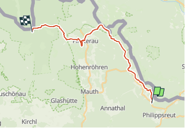
Trail On foot of 21 km to be discovered at Bavaria, Landkreis Freyung-Grafenau, Philippsreut. This trail is proposed by SityTrail - itinéraires balisés pédestres.

Description

Trail created by Nationalpark Bayerischer Wald.

Symbol: Pflanzensymbol (Soldanelle) in schwarz auf weißem quadratischem Grund

Photos

Positioning

Country:
Germany
Region :
Bavaria
Department/Province :
Landkreis Freyung-Grafenau
Municipality :
Philippsreut
Location:
Unknown
Start:(UTM)
402200 ; 5414585 (33U) N.

Trails nearby

Trail On foot Haidmühle - Rundweg 2 Bischofsreut-Marchhäuser-Schnellenzipf - Photo
On foot
PRO

On foot

Easy
Haidmühle, Bavaria, Landkreis Freyung-Grafenau, Germany
3.9 km | 5.6 km-effort
1h 15min
No
Trail On foot Haidmühle - Rundwanderweg 3 Weberbachklause - Photo
On foot
PRO

On foot

Easy
Haidmühle, Bavaria, Landkreis Freyung-Grafenau, Germany
7.2 km | 9.7 km-effort
2h 12min
Yes


Close
My subscriptions