![](/images/other/stat-length.png)
![Trail On foot Unknown - Unterbacher See Rundweg A2 - Photo](https://media.geolcdn.com/t/1900/400/fb0b4672-6d1f-40e5-9bcf-36e3e3992b8e.jpeg&format=pjpeg&maxdim=2)
Unterbacher See Rundweg A2
SityTrail - itinéraires balisés pédestres
Tous les sentiers balisés d’Europe GUIDE+
![Length](/images/other/stat-length.png)
Length
5.5 km
![Max alt](https://static1.geolcdn.com/siteimages/upload/files/1508320355ic_sort_altitude_max_24dp.png)
Max alt
56 m
![Uphill gradient](https://static1.geolcdn.com/siteimages/upload/files/1508320355ic_sort_den_pos_24dp.png)
Uphill gradient
42 m
![Km-Effort](/images/other/stat-length.png)
Km-Effort
6.1 km
![Min alt](https://static1.geolcdn.com/siteimages/upload/files/1508320355ic_sort_altitude_min_24dp.png)
Min alt
41 m
![Downhill gradient](https://static1.geolcdn.com/siteimages/upload/files/1508320355ic_sort_den_neg_24dp.png)
Downhill gradient
44 m
![Boucle](https://static1.geolcdn.com/siteimages/upload/files/16400158638029165_repeat_loop_refresh_sync_direction_icon.png)
Boucle
Yes
Signpost
Creation date :
2022-02-11 12:41:37.132
Updated on :
2022-02-11 12:41:37.132
![On foot](https://static1.geolcdn.com/sitytour/trail-icons/100.png)
1h23
Difficulty : Easy
![Scan this QR Code to open this trail in the SityTrail application](https://capi.geolives.com/qq0zvz2zws4bq2lad0pu/sitytour/trails/3087594/qr.png?size=200)
FREE GPS app for hiking
About
Trail On foot of 5.5 km to be discovered at North Rhine-Westphalia, Dusseldorf, Unknown. This trail is proposed by SityTrail - itinéraires balisés pédestres.
Description
Website: https://sgv-duesseldorf.de/
Positioning
Country:
Germany
Region :
North Rhine-Westphalia
Department/Province :
Dusseldorf
Municipality :
Unknown
Location:
Stadtbezirk 8
Start:(Dec)
Start:(UTM)
351224 ; 5674299 (32U) N.
Comments
Trails nearby
![Trail On foot Erkrath - Neanderlandsteig Entdeckerschleife](https://media.geolcdn.com/t/375/260/f0a4c676-b45d-44ca-9d2f-c9554313404f.jpeg&format=jpg&maxdim=2)
![On foot On foot](https://static1.geolcdn.com/sitytour/trail-icons/100.png)
Neanderlandsteig Entdeckerschleife "Denkmalroute Alt-Erkrath"
On foot
Easy
Erkrath,
North Rhine-Westphalia,
Kreis Mettmann,
Germany
![](/images/other/stat-length.png)
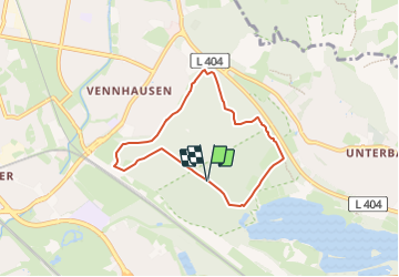
12.4 km | 15.7 km-effort
3h 34min
![](https://static1.geolcdn.com/siteimages/upload/files/16400158638029165_repeat_loop_refresh_sync_direction_icon.png)
No
![Trail On foot Mettmann - Rundwanderweg A3 (Stinderbachtal) - Photo](https://media.geolcdn.com/t/375/260/946deaa5-282a-4d3c-844b-b0f34b41bfd7.jpeg&format=jpg&maxdim=2)
![On foot On foot](https://static1.geolcdn.com/sitytour/trail-icons/100.png)
Rundwanderweg A3 (Stinderbachtal)
On foot
Easy
Mettmann,
North Rhine-Westphalia,
Kreis Mettmann,
Germany
![](/images/other/stat-length.png)
4.8 km | 5.6 km-effort
1h 16min
![](https://static1.geolcdn.com/siteimages/upload/files/16400158638029165_repeat_loop_refresh_sync_direction_icon.png)
Yes
![Trail On foot Unknown - Rechteck Gerresheim-Unterbach - Photo](https://media.geolcdn.com/t/375/260/533e878e-0bfb-411b-a976-bd0edf99eb3a.jpeg&format=jpg&maxdim=2)
![On foot On foot](https://static1.geolcdn.com/sitytour/trail-icons/100.png)
Rechteck Gerresheim-Unterbach
On foot
Easy
Unknown,
North Rhine-Westphalia,
Dusseldorf,
Germany
![](/images/other/stat-length.png)
3.3 km | 4.4 km-effort
1h 0min
![](https://static1.geolcdn.com/siteimages/upload/files/16400158638029165_repeat_loop_refresh_sync_direction_icon.png)
No
![Trail On foot Unknown - Unterbacher See Rundweg A3 - Photo](https://media.geolcdn.com/t/375/260/c913dfa4-e9b0-439a-9a38-a119d4e18ce9.jpeg&format=jpg&maxdim=2)
![On foot On foot](https://static1.geolcdn.com/sitytour/trail-icons/100.png)
Unterbacher See Rundweg A3
On foot
Easy
Unknown,
North Rhine-Westphalia,
Dusseldorf,
Germany
![](/images/other/stat-length.png)
3.5 km | 4 km-effort
53min
![](https://static1.geolcdn.com/siteimages/upload/files/16400158638029165_repeat_loop_refresh_sync_direction_icon.png)
No
![Trail On foot Unknown - Hassels Rundweg A7 - Photo](https://media.geolcdn.com/t/375/260/fda4dd72-3028-45ee-af0c-115df55dd9bd.jpeg&format=jpg&maxdim=2)
![On foot On foot](https://static1.geolcdn.com/sitytour/trail-icons/100.png)
Hassels Rundweg A7
On foot
Easy
Unknown,
North Rhine-Westphalia,
Dusseldorf,
Germany
![](/images/other/stat-length.png)
6.4 km | 6.9 km-effort
1h 34min
![](https://static1.geolcdn.com/siteimages/upload/files/16400158638029165_repeat_loop_refresh_sync_direction_icon.png)
Yes
![Trail On foot Erkrath - Rechteck Erkrath-Eller - Photo](https://media.geolcdn.com/t/375/260/869ed9d6-13d5-459e-9f12-6811fc83e378.jpeg&format=jpg&maxdim=2)
![On foot On foot](https://static1.geolcdn.com/sitytour/trail-icons/100.png)
Rechteck Erkrath-Eller
On foot
Easy
Erkrath,
North Rhine-Westphalia,
Kreis Mettmann,
Germany
![](/images/other/stat-length.png)
5.7 km | 6.7 km-effort
1h 31min
![](https://static1.geolcdn.com/siteimages/upload/files/16400158638029165_repeat_loop_refresh_sync_direction_icon.png)
No
![Trail On foot Erkrath - Doppelbalken Rund um Alt-Erkrath - Photo](https://media.geolcdn.com/t/375/260/fa6b4399-24c9-49f3-9a97-8e33e8c2dfbf.jpeg&format=jpg&maxdim=2)
![On foot On foot](https://static1.geolcdn.com/sitytour/trail-icons/100.png)
Doppelbalken Rund um Alt-Erkrath
On foot
Easy
Erkrath,
North Rhine-Westphalia,
Kreis Mettmann,
Germany
![](/images/other/stat-length.png)
11.5 km | 14.8 km-effort
3h 21min
![](https://static1.geolcdn.com/siteimages/upload/files/16400158638029165_repeat_loop_refresh_sync_direction_icon.png)
Yes
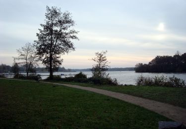
![Trail On foot Unknown - [Volldreieck] Eller - Volksgarten - Photo](https://media.geolcdn.com/t/375/260/8a72960d-3a14-4e60-95e0-99357e2467ee.jpeg&format=jpg&maxdim=2)
![On foot On foot](https://static1.geolcdn.com/sitytour/trail-icons/100.png)
[Volldreieck] Eller - Volksgarten
On foot
Easy
Unknown,
North Rhine-Westphalia,
Dusseldorf,
Germany
![](/images/other/stat-length.png)
6 km | 6.5 km-effort
1h 28min
![](https://static1.geolcdn.com/siteimages/upload/files/16400158638029165_repeat_loop_refresh_sync_direction_icon.png)
No
![Trail On foot Unknown - Hassels Rundweg A6 - Photo](https://media.geolcdn.com/t/375/260/2cd0a983-0c91-4362-93ae-94f2cab1c564.jpeg&format=jpg&maxdim=2)
![On foot On foot](https://static1.geolcdn.com/sitytour/trail-icons/100.png)
Hassels Rundweg A6
On foot
Easy
Unknown,
North Rhine-Westphalia,
Dusseldorf,
Germany
![](/images/other/stat-length.png)
3.6 km | 3.9 km-effort
52min
![](https://static1.geolcdn.com/siteimages/upload/files/16400158638029165_repeat_loop_refresh_sync_direction_icon.png)
Yes