![](/images/other/stat-length.png)
![Trail On foot Eschweiler - Eschweiler Mühlenweg - Photo](https://media.geolcdn.com/t/1900/400/794a0236-8c54-488b-a336-5fe19c410c34.jpeg&format=pjpeg&maxdim=2)
Eschweiler Mühlenweg
SityTrail - itinéraires balisés pédestres
Tous les sentiers balisés d’Europe GUIDE+
![Length](/images/other/stat-length.png)
Length
14.1 km
![Max alt](https://static1.geolcdn.com/siteimages/upload/files/1508320355ic_sort_altitude_max_24dp.png)
Max alt
202 m
![Uphill gradient](https://static1.geolcdn.com/siteimages/upload/files/1508320355ic_sort_den_pos_24dp.png)
Uphill gradient
162 m
![Km-Effort](/images/other/stat-length.png)
Km-Effort
16.2 km
![Min alt](https://static1.geolcdn.com/siteimages/upload/files/1508320355ic_sort_altitude_min_24dp.png)
Min alt
120 m
![Downhill gradient](https://static1.geolcdn.com/siteimages/upload/files/1508320355ic_sort_den_neg_24dp.png)
Downhill gradient
164 m
![Boucle](https://static1.geolcdn.com/siteimages/upload/files/16400158638029165_repeat_loop_refresh_sync_direction_icon.png)
Boucle
Yes
Signpost
Creation date :
2022-02-11 12:41:17.772
Updated on :
2022-02-11 12:41:17.772
![On foot](https://static1.geolcdn.com/sitytour/trail-icons/100.png)
3h41
Difficulty : Easy
![Scan this QR Code to open this trail in the SityTrail application](https://capi.geolives.com/qq0zvz2zws4bq2lad0pu/sitytour/trails/3087566/qr.png?size=200)
FREE GPS app for hiking
About
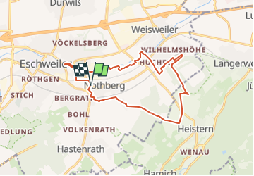
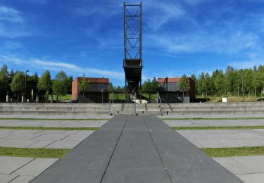
Trail On foot of 14.1 km to be discovered at North Rhine-Westphalia, Städteregion Aachen, Eschweiler. This trail is proposed by SityTrail - itinéraires balisés pédestres.
Description
Trail created by Eifelverein Eschweiler.
Auf Wanderkarten des Eifelvereins seit 2014 nicht mehr enthalten
Symbol: schwarze 4 auf weissem Grund
Positioning
Country:
Germany
Region :
North Rhine-Westphalia
Department/Province :
Städteregion Aachen
Municipality :
Eschweiler
Location:
Unknown
Start:(Dec)
Start:(UTM)
308759 ; 5632268 (32U) N.
Comments
Trails nearby
![Trail On foot Stolberg - Schevenhütte Rundweg 3 - Photo](https://media.geolcdn.com/t/375/260/0d483f44-9c9c-432f-a23e-3b9f818f413c.jpeg&format=jpg&maxdim=2)
![On foot On foot](https://static1.geolcdn.com/sitytour/trail-icons/100.png)
Schevenhütte Rundweg 3
On foot
Easy
Stolberg,
North Rhine-Westphalia,
Städteregion Aachen,
Germany
![](/images/other/stat-length.png)
6.9 km | 9 km-effort
2h 3min
![](https://static1.geolcdn.com/siteimages/upload/files/16400158638029165_repeat_loop_refresh_sync_direction_icon.png)
No
![Trail On foot Stolberg - Stolberg Rundweg 1 - Photo](https://media.geolcdn.com/t/375/260/a577aa09-5d97-44fb-950f-181c01c4b6cd.jpeg&format=jpg&maxdim=2)
![On foot On foot](https://static1.geolcdn.com/sitytour/trail-icons/100.png)
Stolberg Rundweg 1
On foot
Easy
Stolberg,
North Rhine-Westphalia,
Städteregion Aachen,
Germany
![](/images/other/stat-length.png)
9 km | 11.4 km-effort
2h 35min
![](https://static1.geolcdn.com/siteimages/upload/files/16400158638029165_repeat_loop_refresh_sync_direction_icon.png)
No
![Trail On foot Langerwehe - Langerwehe Wanderrundweg Nr. 11 - Photo](https://media.geolcdn.com/t/375/260/69b405e1-5955-4ecf-a90c-332b2358c798.jpeg&format=jpg&maxdim=2)
![On foot On foot](https://static1.geolcdn.com/sitytour/trail-icons/100.png)
Langerwehe Wanderrundweg Nr. 11
On foot
Easy
Langerwehe,
North Rhine-Westphalia,
Kreis Düren,
Germany
![](/images/other/stat-length.png)
9.1 km | 11.1 km-effort
2h 31min
![](https://static1.geolcdn.com/siteimages/upload/files/16400158638029165_repeat_loop_refresh_sync_direction_icon.png)
Yes
![Trail On foot Stolberg - Langerwehe Rundwanderweg Nr. 41 - Photo](https://media.geolcdn.com/t/375/260/885b2889-e761-44ac-8069-32698e7e51e2.jpeg&format=jpg&maxdim=2)
![On foot On foot](https://static1.geolcdn.com/sitytour/trail-icons/100.png)
Langerwehe Rundwanderweg Nr. 41
On foot
Easy
Stolberg,
North Rhine-Westphalia,
Städteregion Aachen,
Germany
![](/images/other/stat-length.png)
12.2 km | 15.1 km-effort
3h 26min
![](https://static1.geolcdn.com/siteimages/upload/files/16400158638029165_repeat_loop_refresh_sync_direction_icon.png)
Yes
![Trail On foot Langerwehe - Langerwehe Wanderrundweg Nr. 31 - Photo](https://media.geolcdn.com/t/375/260/404422ff-d695-461b-8392-02729ac5736e.jpeg&format=jpg&maxdim=2)
![On foot On foot](https://static1.geolcdn.com/sitytour/trail-icons/100.png)
Langerwehe Wanderrundweg Nr. 31
On foot
Easy
Langerwehe,
North Rhine-Westphalia,
Kreis Düren,
Germany
![](/images/other/stat-length.png)
7.2 km | 9.2 km-effort
2h 5min
![](https://static1.geolcdn.com/siteimages/upload/files/16400158638029165_repeat_loop_refresh_sync_direction_icon.png)
Yes
![Trail On foot Eschweiler - Heimatkundlicher Rundwanderweg Eschweiler - Photo](https://media.geolcdn.com/t/375/260/9ec98c1c-540f-417c-86ee-b41a9eee9424.jpeg&format=jpg&maxdim=2)
![On foot On foot](https://static1.geolcdn.com/sitytour/trail-icons/100.png)
Heimatkundlicher Rundwanderweg Eschweiler
On foot
Difficult
Eschweiler,
North Rhine-Westphalia,
Städteregion Aachen,
Germany
![](/images/other/stat-length.png)
29 km | 35 km-effort
7h 53min
![](https://static1.geolcdn.com/siteimages/upload/files/16400158638029165_repeat_loop_refresh_sync_direction_icon.png)
No
![Trail On foot Eschweiler - Eschweiler Bachweg - Photo](https://media.geolcdn.com/t/375/260/da331c82-6b93-4335-8a41-9b8a196f8d22.jpeg&format=jpg&maxdim=2)
![On foot On foot](https://static1.geolcdn.com/sitytour/trail-icons/100.png)
Eschweiler Bachweg
On foot
Medium
Eschweiler,
North Rhine-Westphalia,
Städteregion Aachen,
Germany
![](/images/other/stat-length.png)
22 km | 26 km-effort
5h 52min
![](https://static1.geolcdn.com/siteimages/upload/files/16400158638029165_repeat_loop_refresh_sync_direction_icon.png)
Yes
![Trail On foot Eschweiler - Kleiner Seeweg - Photo](https://media.geolcdn.com/t/375/260/d963b1c8-b18e-4ed3-b6a9-70d9e9f5b1cb.jpeg&format=jpg&maxdim=2)
![On foot On foot](https://static1.geolcdn.com/sitytour/trail-icons/100.png)
Kleiner Seeweg
On foot
Easy
Eschweiler,
North Rhine-Westphalia,
Städteregion Aachen,
Germany
![](/images/other/stat-length.png)
5.6 km | 6.1 km-effort
1h 23min
![](https://static1.geolcdn.com/siteimages/upload/files/16400158638029165_repeat_loop_refresh_sync_direction_icon.png)
No
![Trail Walking Eschweiler - boucle Eschweiler - Photo](https://media.geolcdn.com/t/375/260/ext.jpg?maxdim=2&url=https%3A%2F%2Fstatic1.geolcdn.com%2Fsiteimages%2Fupload%2Ffiles%2F1553511878bg_sport_marche.png)
![Walking Walking](https://static1.geolcdn.com/sitytour/trail-icons/101.png)
boucle Eschweiler
Walking
Easy
Eschweiler,
North Rhine-Westphalia,
Städteregion Aachen,
Germany
![](/images/other/stat-length.png)
3.1 km | 3.6 km-effort
1h 6min
![](https://static1.geolcdn.com/siteimages/upload/files/16400158638029165_repeat_loop_refresh_sync_direction_icon.png)
Yes