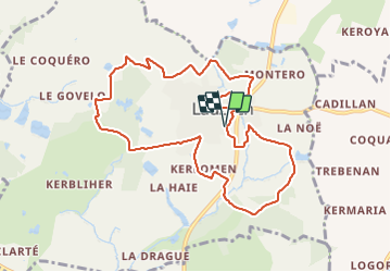
![](/images/other/stat-length.png)
![Trail Walking Lauzach - Boucles du Guernec, Lauzach - Photo](https://media.geolcdn.com/t/1900/400/ext.pjpeg?maxdim=2&url=https%3A%2F%2Fstatic1.geolcdn.com%2Fsiteimages%2Fupload%2Ffiles%2F1553511878bg_sport_marche.png)
Boucles du Guernec, Lauzach
PAM2235
User
![Length](/images/other/stat-length.png)
![Max alt](https://static1.geolcdn.com/siteimages/upload/files/1508320355ic_sort_altitude_max_24dp.png)
![Uphill gradient](https://static1.geolcdn.com/siteimages/upload/files/1508320355ic_sort_den_pos_24dp.png)
![Km-Effort](/images/other/stat-length.png)
![Min alt](https://static1.geolcdn.com/siteimages/upload/files/1508320355ic_sort_altitude_min_24dp.png)
![Downhill gradient](https://static1.geolcdn.com/siteimages/upload/files/1508320355ic_sort_den_neg_24dp.png)
![Boucle](https://static1.geolcdn.com/siteimages/upload/files/16400158638029165_repeat_loop_refresh_sync_direction_icon.png)
![Walking](https://static1.geolcdn.com/sitytour/trail-icons/101.png)
2h25
Difficulty : Medium
![Scan this QR Code to open this trail in the SityTrail application](https://capi.geolives.com/qq0zvz2zws4bq2lad0pu/sitytour/trails/3086814/qr.png?size=200)
FREE GPS app for hiking
About
Trail Walking of 9.8 km to be discovered at Brittany, Morbihan, Lauzach. This trail is proposed by PAM2235.
Description
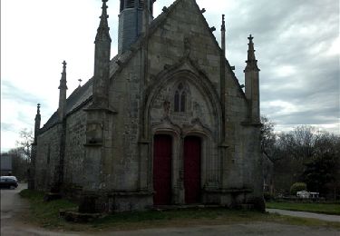
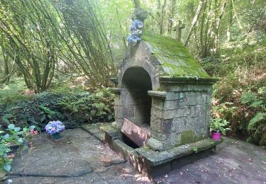
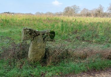
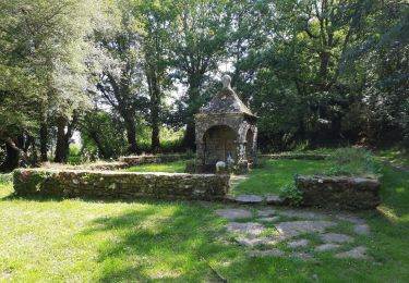
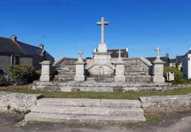
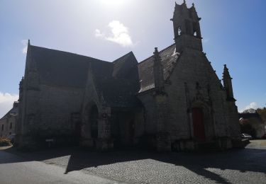
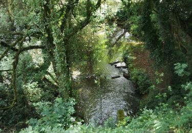
Située au sud du Pays de Questembert, la commune de Lauzach est proche de la rivière de Pénerf et des plages de Damgan. Au long des rives du Guernec, ce circuit sillonne la campagne, et invite à découvrir les monuments comme le Mémorial des guerres d’Indochine et la Chapelle St-Michel. Balisage jaune circuit PR©. Liaison possible vers Berric.
Positioning
Comments
Trails nearby
![Trail Walking Berric - Berric - Circuit des Vertus - Photo](https://media.geolcdn.com/t/375/260/ext.jpg?maxdim=2&url=https%3A%2F%2Fservices.sitytrail.com%2FGeolivesWS%2FDownloadMedia.ashx%3FTrailID%3D178624%26Media%3Da047e8b5-5cf9-4545-b7b7-9961e79ce05d.jpg)
![Walking Walking](https://static1.geolcdn.com/sitytour/trail-icons/101.png)
Walking
![](/images/other/stat-length.png)
![](https://static1.geolcdn.com/siteimages/upload/files/16400158638029165_repeat_loop_refresh_sync_direction_icon.png)
![Trail Walking Berric - PR_56_Berric_AA_01_Circuit1b_Boucle-Des-Vertus_20240825 - Photo](https://media.geolcdn.com/t/375/260/d52766e7-e6f2-4271-86a5-49d1268fc4b5.jpg&format=jpg&maxdim=2)
![Walking Walking](https://static1.geolcdn.com/sitytour/trail-icons/101.png)
Walking
![](/images/other/stat-length.png)
![](https://static1.geolcdn.com/siteimages/upload/files/16400158638029165_repeat_loop_refresh_sync_direction_icon.png)
![Trail Walking Lauzach - PR_56_Lauzach_AA_01_Circuit1b_Boucles-Du-Guernec_20240210 - Photo](https://media.geolcdn.com/t/375/260/97a1b0e1-8a16-4eaf-9878-7259027333e5.jpg&format=jpg&maxdim=2)
![Walking Walking](https://static1.geolcdn.com/sitytour/trail-icons/101.png)
Walking
![](/images/other/stat-length.png)
![](https://static1.geolcdn.com/siteimages/upload/files/16400158638029165_repeat_loop_refresh_sync_direction_icon.png)
![Trail Walking Theix-Noyalo - GRP_Lanvaux_AK_11_Theix_St-Nolf_20210615 - Photo](https://media.geolcdn.com/t/375/260/b7d9e276-6ec7-442e-9d5d-291058f86d11.jpg&format=jpg&maxdim=2)
![Walking Walking](https://static1.geolcdn.com/sitytour/trail-icons/101.png)
Walking
![](/images/other/stat-length.png)
![](https://static1.geolcdn.com/siteimages/upload/files/16400158638029165_repeat_loop_refresh_sync_direction_icon.png)
![Trail Walking Berric - GRP_Lanvaux_AJ_10_Berric_Theix_20210608 - Photo](https://media.geolcdn.com/t/375/260/de084bea-3302-489e-8149-e594a415d03e.jpg&format=jpg&maxdim=2)
![Walking Walking](https://static1.geolcdn.com/sitytour/trail-icons/101.png)
Walking
![](/images/other/stat-length.png)
![](https://static1.geolcdn.com/siteimages/upload/files/16400158638029165_repeat_loop_refresh_sync_direction_icon.png)
![Trail Walking Sulniac - 215- Boucle Le Gorvello Theix - Photo](https://media.geolcdn.com/t/375/260/70c6538d-d3f2-405b-adce-eea4c8c52a77.jpg&format=jpg&maxdim=2)
![Walking Walking](https://static1.geolcdn.com/sitytour/trail-icons/101.png)
Walking
![](/images/other/stat-length.png)
![](https://static1.geolcdn.com/siteimages/upload/files/16400158638029165_repeat_loop_refresh_sync_direction_icon.png)
![Trail Walking Questembert - 181 La boucle de Brangolo - Photo](https://media.geolcdn.com/t/375/260/b7b3446e-266b-4b93-8f5c-6e49ba47c6ad.jpg&format=jpg&maxdim=2)
![Walking Walking](https://static1.geolcdn.com/sitytour/trail-icons/101.png)
Walking
![](/images/other/stat-length.png)
![](https://static1.geolcdn.com/siteimages/upload/files/16400158638029165_repeat_loop_refresh_sync_direction_icon.png)
![Trail Walking Berric - Berric/Le Gorvello - Photo](https://media.geolcdn.com/t/375/260/d5c01ad4-70fa-432b-980c-f4dcfdd1a4a8.jpg&format=jpg&maxdim=2)
![Walking Walking](https://static1.geolcdn.com/sitytour/trail-icons/101.png)
Walking
![](/images/other/stat-length.png)
![](https://static1.geolcdn.com/siteimages/upload/files/16400158638029165_repeat_loop_refresh_sync_direction_icon.png)
![Trail Walking Berric - 160 Rando le Gorvello - Photo](https://media.geolcdn.com/t/375/260/deb32f4a-81c5-4a01-9982-071cb6b3e8b0.jpg&format=jpg&maxdim=2)
![Walking Walking](https://static1.geolcdn.com/sitytour/trail-icons/101.png)
Walking
![](/images/other/stat-length.png)
![](https://static1.geolcdn.com/siteimages/upload/files/16400158638029165_repeat_loop_refresh_sync_direction_icon.png)