![](/images/other/stat-length.png)
![Trail Walking Bièvre - Marche Adeps 5,5 km - Photo](https://media.geolcdn.com/t/1900/400/bf290654-ae18-44cc-a056-07080d7e230f.jpg&format=pjpeg&maxdim=2)
Marche Adeps 5,5 km
Tourisme5555
User
![Length](/images/other/stat-length.png)
Length
5.5 km
![Max alt](https://static1.geolcdn.com/siteimages/upload/files/1508320355ic_sort_altitude_max_24dp.png)
Max alt
402 m
![Uphill gradient](https://static1.geolcdn.com/siteimages/upload/files/1508320355ic_sort_den_pos_24dp.png)
Uphill gradient
110 m
![Km-Effort](/images/other/stat-length.png)
Km-Effort
6.9 km
![Min alt](https://static1.geolcdn.com/siteimages/upload/files/1508320355ic_sort_altitude_min_24dp.png)
Min alt
337 m
![Downhill gradient](https://static1.geolcdn.com/siteimages/upload/files/1508320355ic_sort_den_neg_24dp.png)
Downhill gradient
111 m
![Boucle](https://static1.geolcdn.com/siteimages/upload/files/16400158638029165_repeat_loop_refresh_sync_direction_icon.png)
Boucle
Yes
Creation date :
2022-02-10 15:34:01.618
Updated on :
2022-02-10 15:58:22.448
![Walking](https://static1.geolcdn.com/sitytour/trail-icons/101.png)
1h34
Difficulty : Easy
![Scan this QR Code to open this trail in the SityTrail application](https://capi.geolives.com/qq0zvz2zws4bq2lad0pu/sitytour/trails/3086517/qr.png?size=200)
FREE GPS app for hiking
About
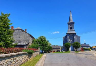
Trail Walking of 5.5 km to be discovered at Wallonia, Namur, Bièvre. This trail is proposed by Tourisme5555.
Description
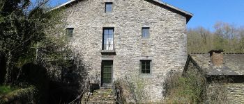
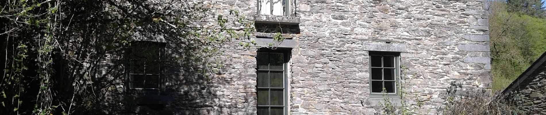
Cette balade passe par le moulin de Mitauge, anciennement moulin à farine, qui a été construit vers 1768 pour les habitants de Oizy.
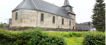
Bon plan : n'hésitez pas à passer en repartant par la chapelle de Oizy. Elle vaut le détour.
Positioning
Country:
Belgium
Region :
Wallonia
Department/Province :
Namur
Municipality :
Bièvre
Location:
Unknown
Start:(Dec)
Start:(UTM)
644190 ; 5528532 (31U) N.
Comments
Trails nearby
![Walking Walking](https://static1.geolcdn.com/sitytour/trail-icons/101.png)
RB-Na-31-Un pays d’étangs et de pépinières
Walking
Very difficult
(5)
Bièvre,
Wallonia,
Namur,
Belgium
![](/images/other/stat-length.png)
21 km | 27 km-effort
6h 14min
![](https://static1.geolcdn.com/siteimages/upload/files/16400158638029165_repeat_loop_refresh_sync_direction_icon.png)
Yes
![Trail Walking Bouillon - RB-Lu-12 - Premier contact avec la Semois au Tombeau du Géant - Photo](https://media.geolcdn.com/t/375/260/ext.jpg?maxdim=2&url=https%3A%2F%2Fservices.sitytrail.com%2FGeolivesWS%2FDownloadMedia.ashx%3FTrailID%3D179617%26Media%3Dd1ff11f2-43fb-4a27-8679-182dbfec36f0.jpg)
![Walking Walking](https://static1.geolcdn.com/sitytour/trail-icons/101.png)
RB-Lu-12 - Premier contact avec la Semois au Tombeau du Géant
Walking
Very difficult
(6)
Bouillon,
Wallonia,
Luxembourg,
Belgium
![](/images/other/stat-length.png)
19.1 km | 27 km-effort
6h 7min
![](https://static1.geolcdn.com/siteimages/upload/files/16400158638029165_repeat_loop_refresh_sync_direction_icon.png)
Yes
![Walking Walking](https://static1.geolcdn.com/sitytour/trail-icons/101.png)
RB-Na-31-Racc_Un-pays-d’étangs-et-de-pépinières
Walking
Very difficult
(2)
Bièvre,
Wallonia,
Namur,
Belgium
![](/images/other/stat-length.png)
16.1 km | 21 km-effort
4h 49min
![](https://static1.geolcdn.com/siteimages/upload/files/16400158638029165_repeat_loop_refresh_sync_direction_icon.png)
Yes
![Trail Walking Bièvre - La roche mouselle bv11 - Photo](https://media.geolcdn.com/t/375/260/180021d9-3dfc-4c34-835a-76474bb7f028.jpg&format=jpg&maxdim=2)
![Walking Walking](https://static1.geolcdn.com/sitytour/trail-icons/101.png)
La roche mouselle bv11
Walking
Easy
(2)
Bièvre,
Wallonia,
Namur,
Belgium
![](/images/other/stat-length.png)
5.5 km | 7.2 km-effort
1h 27min
![](https://static1.geolcdn.com/siteimages/upload/files/16400158638029165_repeat_loop_refresh_sync_direction_icon.png)
Yes
![Trail Walking Bièvre - Promenade de la Roche Mouselle - Petit-Fays - Photo](https://media.geolcdn.com/t/375/260/501e45df-6a5c-4127-b2f5-d1b068aa8215.jpg&format=jpg&maxdim=2)
![Walking Walking](https://static1.geolcdn.com/sitytour/trail-icons/101.png)
Promenade de la Roche Mouselle - Petit-Fays
Walking
Medium
Bièvre,
Wallonia,
Namur,
Belgium
![](/images/other/stat-length.png)
5.5 km | 7.2 km-effort
1h 38min
![](https://static1.geolcdn.com/siteimages/upload/files/16400158638029165_repeat_loop_refresh_sync_direction_icon.png)
Yes
![Trail Walking Paliseul - Marche ADEPS à Carlbourg. 9 km 200 - Photo](https://media.geolcdn.com/t/375/260/bea0c187-f0c2-4e7c-8aec-60125f26f246.jpg&format=jpg&maxdim=2)
![Walking Walking](https://static1.geolcdn.com/sitytour/trail-icons/101.png)
Marche ADEPS à Carlbourg. 9 km 200
Walking
Medium
Paliseul,
Wallonia,
Luxembourg,
Belgium
![](/images/other/stat-length.png)
9.4 km | 12 km-effort
1h 56min
![](https://static1.geolcdn.com/siteimages/upload/files/16400158638029165_repeat_loop_refresh_sync_direction_icon.png)
Yes
![Trail Walking Vresse-sur-Semois - Balade à Chairière - Vresse sur Semois - Photo](https://media.geolcdn.com/t/375/260/2c06f16b-5f0e-4b3d-b0ba-5f1b1ecacfff.jpeg&format=jpg&maxdim=2)
![Walking Walking](https://static1.geolcdn.com/sitytour/trail-icons/101.png)
Balade à Chairière - Vresse sur Semois
Walking
Difficult
(2)
Vresse-sur-Semois,
Wallonia,
Namur,
Belgium
![](/images/other/stat-length.png)
10.9 km | 14.7 km-effort
3h 20min
![](https://static1.geolcdn.com/siteimages/upload/files/16400158638029165_repeat_loop_refresh_sync_direction_icon.png)
Yes
![Trail Walking Bièvre - Balade à Bellefontaine - Bièvre - Photo](https://media.geolcdn.com/t/375/260/479b792a-217f-4a9c-be19-91532b972e2a.jpeg&format=jpg&maxdim=2)
![Walking Walking](https://static1.geolcdn.com/sitytour/trail-icons/101.png)
Balade à Bellefontaine - Bièvre
Walking
Difficult
Bièvre,
Wallonia,
Namur,
Belgium
![](/images/other/stat-length.png)
10 km | 12.9 km-effort
2h 56min
![](https://static1.geolcdn.com/siteimages/upload/files/16400158638029165_repeat_loop_refresh_sync_direction_icon.png)
Yes
![Trail On foot Vresse-sur-Semois - Naglémont - Photo](https://media.geolcdn.com/t/375/260/ext.jpg?maxdim=2&url=https%3A%2F%2Fpivotmedia.tourismewallonie.be%2FOTH-A0-005T-1AB4%2FOTH-A0-005T-1AB4.jpg)
![On foot On foot](https://static1.geolcdn.com/sitytour/trail-icons/100.png)
Naglémont
On foot
Easy
Vresse-sur-Semois,
Wallonia,
Namur,
Belgium
![](/images/other/stat-length.png)
4.9 km | 7.4 km-effort
1h 40min
![](https://static1.geolcdn.com/siteimages/upload/files/16400158638029165_repeat_loop_refresh_sync_direction_icon.png)
Yes