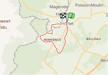
![](/images/other/stat-length.png)
![Trail On foot Vaux-sur-Sûre - Promenade du Bouvreuil - Photo](https://media.geolcdn.com/t/1900/400/ext.pjpeg?maxdim=2&url=https%3A%2F%2Fstatic1.geolcdn.com%2Fsiteimages%2Fupload%2Ffiles%2F1545311037marcheuse_200dpi.jpg)
Promenade du Bouvreuil
SityTrail - itinéraires balisés pédestres
Tous les sentiers balisés d’Europe GUIDE+
![Length](/images/other/stat-length.png)
![Max alt](https://static1.geolcdn.com/siteimages/upload/files/1508320355ic_sort_altitude_max_24dp.png)
![Uphill gradient](https://static1.geolcdn.com/siteimages/upload/files/1508320355ic_sort_den_pos_24dp.png)
![Km-Effort](/images/other/stat-length.png)
![Min alt](https://static1.geolcdn.com/siteimages/upload/files/1508320355ic_sort_altitude_min_24dp.png)
![Downhill gradient](https://static1.geolcdn.com/siteimages/upload/files/1508320355ic_sort_den_neg_24dp.png)
![Boucle](https://static1.geolcdn.com/siteimages/upload/files/16400158638029165_repeat_loop_refresh_sync_direction_icon.png)
![On foot](https://static1.geolcdn.com/sitytour/trail-icons/100.png)
2h24
Difficulty : Easy
![Scan this QR Code to open this trail in the SityTrail application](https://capi.geolives.com/qq0zvz2zws4bq2lad0pu/sitytour/trails/3085436/qr.png?size=200)
FREE GPS app for hiking
About
Trail On foot of 8.8 km to be discovered at Wallonia, Luxembourg, Vaux-sur-Sûre. This trail is proposed by SityTrail - itinéraires balisés pédestres.
Description
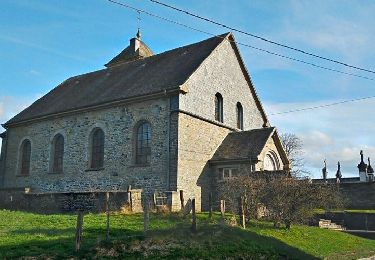
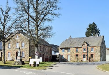
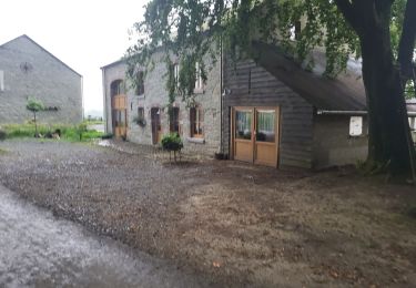
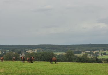
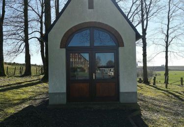
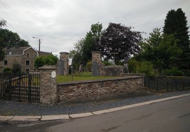
Vaux-sur-Sûre tire la fin de son nom de la rivière qui y prend sa source, la « Sûre ». La commune possède un patrimoine immobilier fourni à travers les villages et les hameaux où l’on ressent une âme rurale préservée. Plusieurs localités de Vaux peuvent aussi se targuer de posséder en leurs centres des églises imposantes au caractère original, qui contrastent avec les nombreuses chapelles éparpillées dans la campagne ardennaise environnante. Ancien cimetière de Sibret (commune de Vaux-sur-Sûre)
Website: http://www.vaux-sur-sure-tourisme.be/promenade-bouvreuil
Positioning
Comments
Trails nearby
![Trail Walking Sainte-Ode - Beauplateau - Promenade du Pleurotte (T7) - Photo](https://media.geolcdn.com/t/375/260/ext.jpg?maxdim=2&url=https%3A%2F%2Fservices.sitytrail.com%2FGeolivesWS%2FDownloadMedia.ashx%3FTrailID%3D334523%26Media%3D18a8c2b6-d141-493c-b9d2-49dc585d80d8.JPG)
![Walking Walking](https://static1.geolcdn.com/sitytour/trail-icons/101.png)
Walking
![](/images/other/stat-length.png)
![](https://static1.geolcdn.com/siteimages/upload/files/16400158638029165_repeat_loop_refresh_sync_direction_icon.png)
![Trail Walking Sainte-Ode - Beauplateau - Le sentier du Coprin (GTA 4) - Photo](https://media.geolcdn.com/t/375/260/ext.jpg?maxdim=2&url=https%3A%2F%2Fservices.sitytrail.com%2FGeolivesWS%2FDownloadMedia.ashx%3FTrailID%3D334529%26Media%3D1279e9c3-3916-4d33-8e39-244a46eb0999.png)
![Walking Walking](https://static1.geolcdn.com/sitytour/trail-icons/101.png)
Walking
![](/images/other/stat-length.png)
![](https://static1.geolcdn.com/siteimages/upload/files/16400158638029165_repeat_loop_refresh_sync_direction_icon.png)
![Trail Walking Sainte-Ode - Magerotte - Promenade des Haies de Magery (T4) - Photo](https://media.geolcdn.com/t/375/260/ext.jpg?maxdim=2&url=https%3A%2F%2Fstatic1.geolcdn.com%2Fsiteimages%2Fupload%2Ffiles%2F1553511878bg_sport_marche.png)
![Walking Walking](https://static1.geolcdn.com/sitytour/trail-icons/101.png)
Walking
![](/images/other/stat-length.png)
![](https://static1.geolcdn.com/siteimages/upload/files/16400158638029165_repeat_loop_refresh_sync_direction_icon.png)
![Trail On foot Vaux-sur-Sûre - Promenade des Vanneaux - Photo](https://media.geolcdn.com/t/375/260/f25bda7f-df07-4cae-a9a3-cfe0c9000b2b.jpeg&format=jpg&maxdim=2)
![On foot On foot](https://static1.geolcdn.com/sitytour/trail-icons/100.png)
On foot
![](/images/other/stat-length.png)
![](https://static1.geolcdn.com/siteimages/upload/files/16400158638029165_repeat_loop_refresh_sync_direction_icon.png)
![Trail On foot Sainte-Ode - 2. Le sentier du Cèpe de Bordeaux - Photo](https://media.geolcdn.com/t/375/260/ef2c7c30-09aa-4b3d-9065-55ec6e8ad57e.jpeg&format=jpg&maxdim=2)
![On foot On foot](https://static1.geolcdn.com/sitytour/trail-icons/100.png)
On foot
![](/images/other/stat-length.png)
![](https://static1.geolcdn.com/siteimages/upload/files/16400158638029165_repeat_loop_refresh_sync_direction_icon.png)
![Trail Walking Sainte-Ode - Beauplateau Ste Ode 240823 - Photo](https://media.geolcdn.com/t/375/260/94631907-5f0b-4b3a-9806-13dd748b318a.jpg&format=jpg&maxdim=2)
![Walking Walking](https://static1.geolcdn.com/sitytour/trail-icons/101.png)
Walking
![](/images/other/stat-length.png)
![](https://static1.geolcdn.com/siteimages/upload/files/16400158638029165_repeat_loop_refresh_sync_direction_icon.png)
![Trail Walking Sainte-Ode - rando beauplateau 24-08-2023 - Photo](https://media.geolcdn.com/t/375/260/6f1baeb9-1089-4f6c-bd11-5d0c9235b08b.jpg&format=jpg&maxdim=2)
![Walking Walking](https://static1.geolcdn.com/sitytour/trail-icons/101.png)
Walking
![](/images/other/stat-length.png)
![](https://static1.geolcdn.com/siteimages/upload/files/16400158638029165_repeat_loop_refresh_sync_direction_icon.png)
![Trail On foot Vaux-sur-Sûre - Promenade de la Truite - Photo](https://media.geolcdn.com/t/375/260/dc8e6a7d-10c2-483c-849c-2c2e40a6aa00.jpeg&format=jpg&maxdim=2)
![On foot On foot](https://static1.geolcdn.com/sitytour/trail-icons/100.png)
On foot
![](/images/other/stat-length.png)
![](https://static1.geolcdn.com/siteimages/upload/files/16400158638029165_repeat_loop_refresh_sync_direction_icon.png)
![Trail On foot Vaux-sur-Sûre - Promenade du Loup - Photo](https://media.geolcdn.com/t/375/260/a4b7c189-2aa3-4341-b070-c509f488a2a0.jpeg&format=jpg&maxdim=2)
![On foot On foot](https://static1.geolcdn.com/sitytour/trail-icons/100.png)
On foot
![](/images/other/stat-length.png)
![](https://static1.geolcdn.com/siteimages/upload/files/16400158638029165_repeat_loop_refresh_sync_direction_icon.png)