![](/images/other/stat-length.png)
![Trail On foot Ghent - Leeuwenhof wandeling - Photo](https://media.geolcdn.com/t/1900/400/d9bc68bb-84e4-43b5-bfa1-638e3a2ebc41.jpeg&format=pjpeg&maxdim=2)
Leeuwenhof wandeling
SityTrail - itinéraires balisés pédestres
Tous les sentiers balisés d’Europe GUIDE+
![Length](/images/other/stat-length.png)
Length
4.4 km
![Max alt](https://static1.geolcdn.com/siteimages/upload/files/1508320355ic_sort_altitude_max_24dp.png)
Max alt
16 m
![Uphill gradient](https://static1.geolcdn.com/siteimages/upload/files/1508320355ic_sort_den_pos_24dp.png)
Uphill gradient
30 m
![Km-Effort](/images/other/stat-length.png)
Km-Effort
4.8 km
![Min alt](https://static1.geolcdn.com/siteimages/upload/files/1508320355ic_sort_altitude_min_24dp.png)
Min alt
1 m
![Downhill gradient](https://static1.geolcdn.com/siteimages/upload/files/1508320355ic_sort_den_neg_24dp.png)
Downhill gradient
32 m
![Boucle](https://static1.geolcdn.com/siteimages/upload/files/16400158638029165_repeat_loop_refresh_sync_direction_icon.png)
Boucle
Yes
Signpost
Creation date :
2022-02-09 19:24:14.629
Updated on :
2022-02-09 19:24:14.629
![On foot](https://static1.geolcdn.com/sitytour/trail-icons/100.png)
1h04
Difficulty : Easy
![Scan this QR Code to open this trail in the SityTrail application](https://capi.geolives.com/qq0zvz2zws4bq2lad0pu/sitytour/trails/3085392/qr.png?size=200)
FREE GPS app for hiking
About
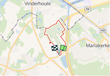
Trail On foot of 4.4 km to be discovered at Flanders, East Flanders, Ghent. This trail is proposed by SityTrail - itinéraires balisés pédestres.
Description
Trail created by Vlaamse landmaatschappij.
Symbol: square
Website: https://www.vlm.be/nl/groenpool-vinderhoutse-bossen
Positioning
Country:
Belgium
Region :
Flanders
Department/Province :
East Flanders
Municipality :
Ghent
Location:
Drongen
Start:(Dec)
Start:(UTM)
545765 ; 5657748 (31U) N.
Comments
Trails nearby
![Electric bike Electric bike](https://static1.geolcdn.com/sitytour/trail-icons/205.png)
fietstocht 13-06-2021 sterretrappers
Electric bike
Very easy
(1)
Ghent,
Flanders,
East Flanders,
Belgium
![](/images/other/stat-length.png)
33 km | 36 km-effort
Unknown
![](https://static1.geolcdn.com/siteimages/upload/files/16400158638029165_repeat_loop_refresh_sync_direction_icon.png)
Yes
![Trail On foot Ghent - Door Luchteren en Oude Kale - Photo](https://media.geolcdn.com/t/375/260/abded955-6a98-4333-a17f-cc251ab7d5c3.jpeg&format=jpg&maxdim=2)
![On foot On foot](https://static1.geolcdn.com/sitytour/trail-icons/100.png)
Door Luchteren en Oude Kale
On foot
Easy
Ghent,
Flanders,
East Flanders,
Belgium
![](/images/other/stat-length.png)
9.7 km | 10.4 km-effort
2h 21min
![](https://static1.geolcdn.com/siteimages/upload/files/16400158638029165_repeat_loop_refresh_sync_direction_icon.png)
Yes
![Trail On foot Ghent - Vinderhoutse Bossen wandeling - Photo](https://media.geolcdn.com/t/375/260/572659ee-7cae-4b58-81f1-828035b8848e.jpeg&format=jpg&maxdim=2)
![On foot On foot](https://static1.geolcdn.com/sitytour/trail-icons/100.png)
Vinderhoutse Bossen wandeling
On foot
Easy
Ghent,
Flanders,
East Flanders,
Belgium
![](/images/other/stat-length.png)
9.8 km | 10.6 km-effort
2h 24min
![](https://static1.geolcdn.com/siteimages/upload/files/16400158638029165_repeat_loop_refresh_sync_direction_icon.png)
Yes
![Trail On foot Ghent - Campagne wandeling - Photo](https://media.geolcdn.com/t/375/260/3d89c286-67ac-4ed8-9d51-a3e73cef8982.jpeg&format=jpg&maxdim=2)
![On foot On foot](https://static1.geolcdn.com/sitytour/trail-icons/100.png)
Campagne wandeling
On foot
Easy
Ghent,
Flanders,
East Flanders,
Belgium
![](/images/other/stat-length.png)
7 km | 7.5 km-effort
1h 41min
![](https://static1.geolcdn.com/siteimages/upload/files/16400158638029165_repeat_loop_refresh_sync_direction_icon.png)
Yes
![Trail On foot Ghent - Claeys-Boúúaert wandeling - Photo](https://media.geolcdn.com/t/375/260/921051f5-906e-47ac-b9c1-2a14046aee3f.jpeg&format=jpg&maxdim=2)
![On foot On foot](https://static1.geolcdn.com/sitytour/trail-icons/100.png)
Claeys-Boúúaert wandeling
On foot
Easy
Ghent,
Flanders,
East Flanders,
Belgium
![](/images/other/stat-length.png)
9.3 km | 10 km-effort
2h 15min
![](https://static1.geolcdn.com/siteimages/upload/files/16400158638029165_repeat_loop_refresh_sync_direction_icon.png)
Yes
![Trail On foot Ghent - Bourgoyen-Ossemeersen - Bourgoyenpad - Photo](https://media.geolcdn.com/t/375/260/d0c2b3a9-5166-4f7a-9c9b-65fdd66fe07a.jpeg&format=jpg&maxdim=2)
![On foot On foot](https://static1.geolcdn.com/sitytour/trail-icons/100.png)
Bourgoyen-Ossemeersen - Bourgoyenpad
On foot
Easy
Ghent,
Flanders,
East Flanders,
Belgium
![](/images/other/stat-length.png)
5.1 km | 5.7 km-effort
1h 18min
![](https://static1.geolcdn.com/siteimages/upload/files/16400158638029165_repeat_loop_refresh_sync_direction_icon.png)
Yes
![Trail On foot Deinze - Oude Kalevallei - Lus 2 - Photo](https://media.geolcdn.com/t/375/260/9a68d079-d324-441f-ab36-1b80e1608fb1.jpeg&format=jpg&maxdim=2)
![On foot On foot](https://static1.geolcdn.com/sitytour/trail-icons/100.png)
Oude Kalevallei - Lus 2
On foot
Easy
Deinze,
Flanders,
East Flanders,
Belgium
![](/images/other/stat-length.png)
3.7 km | 3.9 km-effort
53min
![](https://static1.geolcdn.com/siteimages/upload/files/16400158638029165_repeat_loop_refresh_sync_direction_icon.png)
Yes
![Trail Walking Ghent - Gand - Photo](https://media.geolcdn.com/t/375/260/becae5b4-1bd8-4ed9-a858-eb6535ae6c85.jpg&format=jpg&maxdim=2)
![Walking Walking](https://static1.geolcdn.com/sitytour/trail-icons/101.png)
Gand
Walking
Very easy
(1)
Ghent,
Flanders,
East Flanders,
Belgium
![](/images/other/stat-length.png)
11.5 km | 12.5 km-effort
2h 40min
![](https://static1.geolcdn.com/siteimages/upload/files/16400158638029165_repeat_loop_refresh_sync_direction_icon.png)
No
![Trail Walking Ghent - Gent Centrum - Photo](https://media.geolcdn.com/t/375/260/ext.jpg?maxdim=2&url=https%3A%2F%2Fstatic1.geolcdn.com%2Fsiteimages%2Fupload%2Ffiles%2F1553511878bg_sport_marche.png)
![Walking Walking](https://static1.geolcdn.com/sitytour/trail-icons/101.png)
Gent Centrum
Walking
Medium
(1)
Ghent,
Flanders,
East Flanders,
Belgium
![](/images/other/stat-length.png)
3.1 km | 3.4 km-effort
45min
![](https://static1.geolcdn.com/siteimages/upload/files/16400158638029165_repeat_loop_refresh_sync_direction_icon.png)
Yes