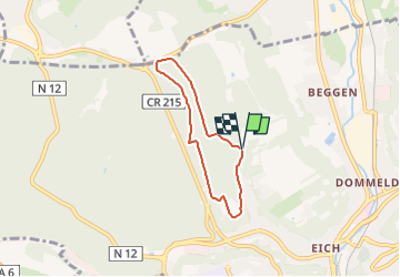
![](/images/other/stat-length.png)
![Trail On foot Luxembourg - Maple leaf - Photo](https://media.geolcdn.com/t/1900/400/a23d593d-2772-4b4d-9b30-c01313559189.jpeg&format=pjpeg&maxdim=2)
Maple leaf
SityTrail - itinéraires balisés pédestres
Tous les sentiers balisés d’Europe GUIDE+
![Length](/images/other/stat-length.png)
![Max alt](https://static1.geolcdn.com/siteimages/upload/files/1508320355ic_sort_altitude_max_24dp.png)
![Uphill gradient](https://static1.geolcdn.com/siteimages/upload/files/1508320355ic_sort_den_pos_24dp.png)
![Km-Effort](/images/other/stat-length.png)
![Min alt](https://static1.geolcdn.com/siteimages/upload/files/1508320355ic_sort_altitude_min_24dp.png)
![Downhill gradient](https://static1.geolcdn.com/siteimages/upload/files/1508320355ic_sort_den_neg_24dp.png)
![Boucle](https://static1.geolcdn.com/siteimages/upload/files/16400158638029165_repeat_loop_refresh_sync_direction_icon.png)
![On foot](https://static1.geolcdn.com/sitytour/trail-icons/100.png)
1h21
Difficulty : Easy
![Scan this QR Code to open this trail in the SityTrail application](https://capi.geolives.com/qq0zvz2zws4bq2lad0pu/sitytour/trails/3085294/qr.png?size=200)
FREE GPS app for hiking
About
Trail On foot of 4.7 km to be discovered at Unknown, Canton Luxembourg, Luxembourg. This trail is proposed by SityTrail - itinéraires balisés pédestres.
Description
Les forêts de la Ville réservent de nombreuses opportunités pour passer des moments de détente et de relaxation avec 7 circuits balisés au Bambësch, 6 circuits balisés à Hamm, Cents et Bonnevoie, 1 circuit balisé à la Kockelscheuer et des suggestions de trajets pour la course à pied.
Website: https://www.vdl.lu/fr/visiter/loisirs-et-nature/promenades-et-parcours/promenades-et-courses-pied#
Positioning
Comments
Trails nearby
![Trail Walking Luxembourg - Itinérant Luxembourg Jour 1 : Visite de Luxembourg Ville - Photo](https://media.geolcdn.com/t/375/260/35d80b54-5540-4eaf-ab66-fd3323c5eeb0.jpg&format=jpg&maxdim=2)
![Walking Walking](https://static1.geolcdn.com/sitytour/trail-icons/101.png)
Walking
![](/images/other/stat-length.png)
![](https://static1.geolcdn.com/siteimages/upload/files/16400158638029165_repeat_loop_refresh_sync_direction_icon.png)
![Trail On foot Walferdange - Auto-Pédestre Bereldange - Photo](https://media.geolcdn.com/t/375/260/9ffb96c9-8ee3-4baa-8f73-3ae3b0006373.jpeg&format=jpg&maxdim=2)
![On foot On foot](https://static1.geolcdn.com/sitytour/trail-icons/100.png)
On foot
![](/images/other/stat-length.png)
![](https://static1.geolcdn.com/siteimages/upload/files/16400158638029165_repeat_loop_refresh_sync_direction_icon.png)
![Trail On foot Kopstal - Auto-Pédestre Bridel - Photo](https://media.geolcdn.com/t/375/260/aba8129c-2559-49c6-88a8-671618ad91d5.jpeg&format=jpg&maxdim=2)
![On foot On foot](https://static1.geolcdn.com/sitytour/trail-icons/100.png)
On foot
![](/images/other/stat-length.png)
![](https://static1.geolcdn.com/siteimages/upload/files/16400158638029165_repeat_loop_refresh_sync_direction_icon.png)
![Trail On foot Luxembourg - Sentier pédestre Hibou - Photo](https://media.geolcdn.com/t/375/260/b315718c-907d-46e0-8a6a-fbd567016707.jpeg&format=jpg&maxdim=2)
![On foot On foot](https://static1.geolcdn.com/sitytour/trail-icons/100.png)
On foot
![](/images/other/stat-length.png)
![](https://static1.geolcdn.com/siteimages/upload/files/16400158638029165_repeat_loop_refresh_sync_direction_icon.png)
![Trail On foot Luxembourg - Parcours de cross - Photo](https://media.geolcdn.com/t/375/260/e3e160d8-098a-430f-a621-d8ccdea5d783.jpeg&format=jpg&maxdim=2)
![On foot On foot](https://static1.geolcdn.com/sitytour/trail-icons/100.png)
On foot
![](/images/other/stat-length.png)
![](https://static1.geolcdn.com/siteimages/upload/files/16400158638029165_repeat_loop_refresh_sync_direction_icon.png)
![Trail On foot Strassen - Autopédestre Strassen - Photo](https://media.geolcdn.com/t/375/260/619a8f5e-8ad2-4364-bab9-943448960860.jpeg&format=jpg&maxdim=2)
![On foot On foot](https://static1.geolcdn.com/sitytour/trail-icons/100.png)
On foot
![](/images/other/stat-length.png)
![](https://static1.geolcdn.com/siteimages/upload/files/16400158638029165_repeat_loop_refresh_sync_direction_icon.png)
![Trail Walking Steinsel - Autopedestres : Steinsel - Photo](https://media.geolcdn.com/t/375/260/ext.jpg?maxdim=2&url=https%3A%2F%2Fstatic1.geolcdn.com%2Fsiteimages%2Fupload%2Ffiles%2F1553511878bg_sport_marche.png)
![Walking Walking](https://static1.geolcdn.com/sitytour/trail-icons/101.png)
Walking
![](/images/other/stat-length.png)
![](https://static1.geolcdn.com/siteimages/upload/files/16400158638029165_repeat_loop_refresh_sync_direction_icon.png)
![Nordic walking Nordic walking](https://static1.geolcdn.com/sitytour/trail-icons/102.png)
Nordic walking
![](/images/other/stat-length.png)
![](https://static1.geolcdn.com/siteimages/upload/files/16400158638029165_repeat_loop_refresh_sync_direction_icon.png)
![Trail Walking Steinsel - Ballade en forêt de Grünewald - Photo](https://media.geolcdn.com/t/375/260/a4894e5a-d97d-4f4c-aad4-4a4eab35481f.jpg&format=jpg&maxdim=2)
![Walking Walking](https://static1.geolcdn.com/sitytour/trail-icons/101.png)
Walking
![](/images/other/stat-length.png)
![](https://static1.geolcdn.com/siteimages/upload/files/16400158638029165_repeat_loop_refresh_sync_direction_icon.png)