![](/images/other/stat-length.png)
![Trail On foot Waimes - Balade de rêve 17 - Du lac aux sources de Quareu - Photo](https://media.geolcdn.com/t/1900/400/0b2e3a09-8094-4f48-a5e9-a165be516240.jpeg&format=pjpeg&maxdim=2)
Balade de rêve 17 - Du lac aux sources de Quareu
SityTrail - itinéraires balisés pédestres
Tous les sentiers balisés d’Europe GUIDE+
![Length](/images/other/stat-length.png)
Length
8.4 km
![Max alt](https://static1.geolcdn.com/siteimages/upload/files/1508320355ic_sort_altitude_max_24dp.png)
Max alt
553 m
![Uphill gradient](https://static1.geolcdn.com/siteimages/upload/files/1508320355ic_sort_den_pos_24dp.png)
Uphill gradient
128 m
![Km-Effort](/images/other/stat-length.png)
Km-Effort
10.1 km
![Min alt](https://static1.geolcdn.com/siteimages/upload/files/1508320355ic_sort_altitude_min_24dp.png)
Min alt
498 m
![Downhill gradient](https://static1.geolcdn.com/siteimages/upload/files/1508320355ic_sort_den_neg_24dp.png)
Downhill gradient
126 m
![Boucle](https://static1.geolcdn.com/siteimages/upload/files/16400158638029165_repeat_loop_refresh_sync_direction_icon.png)
Boucle
Yes
Signpost
Creation date :
2022-02-09 19:18:56.131
Updated on :
2022-04-29 16:42:18.504
![On foot](https://static1.geolcdn.com/sitytour/trail-icons/100.png)
2h17
Difficulty : Easy
![Scan this QR Code to open this trail in the SityTrail application](https://capi.geolives.com/qq0zvz2zws4bq2lad0pu/sitytour/trails/3085280/qr.png?size=200)
FREE GPS app for hiking
About
Trail On foot of 8.4 km to be discovered at Wallonia, Liège, Waimes. This trail is proposed by SityTrail - itinéraires balisés pédestres.
Description
Website: https://www.ostbelgien.eu/fr/fiche/hiking/balades-de-reve-17-robertville#dmdtab=oax-tab7
Positioning
Country:
Belgium
Region :
Wallonia
Department/Province :
Liège
Municipality :
Waimes
Location:
Unknown
Start:(Dec)
Start:(UTM)
296548 ; 5591873 (32U) N.
Comments
Trails nearby
![Trail Walking Waimes - Sourbrodt - Circuit Natura 2000, des sites qui valent le détour - Lg11 - Photo](https://media.geolcdn.com/t/375/260/ext.jpg?maxdim=2&url=https%3A%2F%2Fservices.sitytrail.com%2FGeolivesWS%2FDownloadMedia.ashx%3FTrailID%3D181919%26Media%3Dc17de19f-5f6c-4ae3-b0c2-a0399f656a6f.jpg)
![Walking Walking](https://static1.geolcdn.com/sitytour/trail-icons/101.png)
Sourbrodt - Circuit Natura 2000, des sites qui valent le détour - Lg11
Walking
Easy
(9)
Waimes,
Wallonia,
Liège,
Belgium
![](/images/other/stat-length.png)
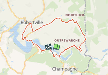
7.3 km | 8.3 km-effort
1h 50min
![](https://static1.geolcdn.com/siteimages/upload/files/16400158638029165_repeat_loop_refresh_sync_direction_icon.png)
Yes
![Trail Walking Waimes - Balade Peak Myrtille avec extension - restaurée - Photo](https://media.geolcdn.com/t/375/260/ext.jpg?maxdim=2&url=https%3A%2F%2Fstatic1.geolcdn.com%2Fsiteimages%2Fupload%2Ffiles%2F1553511878bg_sport_marche.png)
![Walking Walking](https://static1.geolcdn.com/sitytour/trail-icons/101.png)
Balade Peak Myrtille avec extension - restaurée
Walking
Medium
(43)
Waimes,
Wallonia,
Liège,
Belgium
![](/images/other/stat-length.png)
4.9 km | 6 km-effort
1h 22min
![](https://static1.geolcdn.com/siteimages/upload/files/16400158638029165_repeat_loop_refresh_sync_direction_icon.png)
Yes
![Trail Walking Waimes - Balade Peak Myrtille - restaurée - Photo](https://media.geolcdn.com/t/375/260/ext.jpg?maxdim=2&url=https%3A%2F%2Fstatic1.geolcdn.com%2Fsiteimages%2Fupload%2Ffiles%2F1553511878bg_sport_marche.png)
![Walking Walking](https://static1.geolcdn.com/sitytour/trail-icons/101.png)
Balade Peak Myrtille - restaurée
Walking
Easy
(20)
Waimes,
Wallonia,
Liège,
Belgium
![](/images/other/stat-length.png)
2.7 km | 3.3 km-effort
45min
![](https://static1.geolcdn.com/siteimages/upload/files/16400158638029165_repeat_loop_refresh_sync_direction_icon.png)
Yes
![Trail Walking Waimes - 2023-11-10_22h16m17_t119964214_sur les versants de la warchenne w10.gpx.xml - Photo](https://media.geolcdn.com/t/375/260/ca458986-945b-4d88-aa31-13c1465e60e5.jpg&format=jpg&maxdim=2)
![Walking Walking](https://static1.geolcdn.com/sitytour/trail-icons/101.png)
2023-11-10_22h16m17_t119964214_sur les versants de la warchenne w10.gpx.xml
Walking
Medium
(2)
Waimes,
Wallonia,
Liège,
Belgium
![](/images/other/stat-length.png)
6.8 km | 8.6 km-effort
1h 57min
![](https://static1.geolcdn.com/siteimages/upload/files/16400158638029165_repeat_loop_refresh_sync_direction_icon.png)
Yes
![Trail Walking Waimes - Balade Peak Beer IPA (new) - Photo](https://media.geolcdn.com/t/375/260/69787633-7ca3-4264-9ec3-6547631cb468.png&format=jpg&maxdim=2)
![Walking Walking](https://static1.geolcdn.com/sitytour/trail-icons/101.png)
Balade Peak Beer IPA (new)
Walking
Medium
(37)
Waimes,
Wallonia,
Liège,
Belgium
![](/images/other/stat-length.png)
9.7 km | 12 km-effort
2h 43min
![](https://static1.geolcdn.com/siteimages/upload/files/16400158638029165_repeat_loop_refresh_sync_direction_icon.png)
Yes
![Trail Walking Waimes - Prak beer brune - Photo](https://media.geolcdn.com/t/375/260/1004a3fe-d135-46da-92fc-7d19402e96c0.jpg&format=jpg&maxdim=2)
![Walking Walking](https://static1.geolcdn.com/sitytour/trail-icons/101.png)
Prak beer brune
Walking
Medium
(2)
Waimes,
Wallonia,
Liège,
Belgium
![](/images/other/stat-length.png)
6.2 km | 8 km-effort
1h 38min
![](https://static1.geolcdn.com/siteimages/upload/files/16400158638029165_repeat_loop_refresh_sync_direction_icon.png)
Yes
![Trail Walking Waimes - Walk Peak Beer blonde (new) - Photo](https://media.geolcdn.com/t/375/260/c0456a2b-95a4-4137-bfcd-2a58a70f1815.png&format=jpg&maxdim=2)
![Walking Walking](https://static1.geolcdn.com/sitytour/trail-icons/101.png)
Walk Peak Beer blonde (new)
Walking
Difficult
(44)
Waimes,
Wallonia,
Liège,
Belgium
![](/images/other/stat-length.png)
11 km | 13.1 km-effort
2h 58min
![](https://static1.geolcdn.com/siteimages/upload/files/16400158638029165_repeat_loop_refresh_sync_direction_icon.png)
Yes
![Trail Walking Malmedy - xhoffraix . cheneux . moulin et cascade bayehon . vieux chêne . longfaye . xhoffraix - Photo](https://media.geolcdn.com/t/375/260/d03e0c64-90c0-4767-998e-9e240f1eb32e.jpg&format=jpg&maxdim=2)
![Walking Walking](https://static1.geolcdn.com/sitytour/trail-icons/101.png)
xhoffraix . cheneux . moulin et cascade bayehon . vieux chêne . longfaye . xh...
Walking
Easy
(2)
Malmedy,
Wallonia,
Liège,
Belgium
![](/images/other/stat-length.png)
12.3 km | 15.9 km-effort
3h 7min
![](https://static1.geolcdn.com/siteimages/upload/files/16400158638029165_repeat_loop_refresh_sync_direction_icon.png)
Yes
![Trail Walking Waimes - Waimes 21 km - Photo](https://media.geolcdn.com/t/375/260/ae7b64e4-00bf-4852-8640-e3d490be341c.jpg&format=jpg&maxdim=2)
![Walking Walking](https://static1.geolcdn.com/sitytour/trail-icons/101.png)