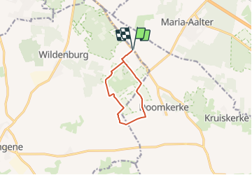
![](/images/other/stat-length.png)
![Trail On foot Wingene - Gulke Putten - Blauwe Wandeling - Photo](https://media.geolcdn.com/t/1900/400/fd3079bb-35b7-49fc-8864-da1b40752982.jpeg&format=pjpeg&maxdim=2)
Gulke Putten - Blauwe Wandeling
SityTrail - itinéraires balisés pédestres
Tous les sentiers balisés d’Europe GUIDE+
![Length](/images/other/stat-length.png)
![Max alt](https://static1.geolcdn.com/siteimages/upload/files/1508320355ic_sort_altitude_max_24dp.png)
![Uphill gradient](https://static1.geolcdn.com/siteimages/upload/files/1508320355ic_sort_den_pos_24dp.png)
![Km-Effort](/images/other/stat-length.png)
![Min alt](https://static1.geolcdn.com/siteimages/upload/files/1508320355ic_sort_altitude_min_24dp.png)
![Downhill gradient](https://static1.geolcdn.com/siteimages/upload/files/1508320355ic_sort_den_neg_24dp.png)
![Boucle](https://static1.geolcdn.com/siteimages/upload/files/16400158638029165_repeat_loop_refresh_sync_direction_icon.png)
![On foot](https://static1.geolcdn.com/sitytour/trail-icons/100.png)
1h49
Difficulty : Easy
![Scan this QR Code to open this trail in the SityTrail application](https://capi.geolives.com/qq0zvz2zws4bq2lad0pu/sitytour/trails/3085216/qr.png?size=200)
FREE GPS app for hiking
About
Trail On foot of 7.3 km to be discovered at Flanders, West Flanders, Wingene. This trail is proposed by SityTrail - itinéraires balisés pédestres.
Description
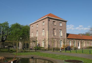
Opgelet! De paden kunnen extra modderig zijn. Tussen Beernem en Ruiselede, ten zuiden van Brugge, ligt het natuurgebied Gulke Putten. Daar gedijen enkele van de meest zeldzame dieren van Vlaanderen. Kom er wandelen en geniet van bloemenrijke paden, rustieke bossen en uitgestrekte graslanden. Op de voormalige landbouwgronden met heide en brem grazen gallowayrunderen. Een ontmoeting met deze goedzakken maakt van jouw wandeling een onvergetelijk moment!
Website: https://www.natuurpunt.be/natuurgebied/gulke-putten
Positioning
Comments
Trails nearby
![Trail On foot Beernem - Bulskampveldwandelroute - Photo](https://media.geolcdn.com/t/375/260/b6635d51-9eef-4271-bdb7-3c0b227bd424.jpeg&format=jpg&maxdim=2)
![On foot On foot](https://static1.geolcdn.com/sitytour/trail-icons/100.png)
On foot
![](/images/other/stat-length.png)
![](https://static1.geolcdn.com/siteimages/upload/files/16400158638029165_repeat_loop_refresh_sync_direction_icon.png)
![Trail On foot Wingene - Wildenburg wandelroute - Photo](https://media.geolcdn.com/t/375/260/fd3079bb-35b7-49fc-8864-da1b40752982.jpeg&format=jpg&maxdim=2)
![On foot On foot](https://static1.geolcdn.com/sitytour/trail-icons/100.png)
On foot
![](/images/other/stat-length.png)
![](https://static1.geolcdn.com/siteimages/upload/files/16400158638029165_repeat_loop_refresh_sync_direction_icon.png)
![Trail Running Beernem - Bulskampveld - Photo](https://media.geolcdn.com/t/375/260/ext.jpg?maxdim=2&url=https%3A%2F%2Fstatic1.geolcdn.com%2Fsiteimages%2Fupload%2Ffiles%2F1524743154running.jpg)
![Running Running](https://static1.geolcdn.com/sitytour/trail-icons/103.png)
Running
![](/images/other/stat-length.png)
![](https://static1.geolcdn.com/siteimages/upload/files/16400158638029165_repeat_loop_refresh_sync_direction_icon.png)
![Trail On foot Wingene - Gulke Putten - Rode Wandeling - Photo](https://media.geolcdn.com/t/375/260/5451753e-b4c5-4b69-854e-997059cec17e.jpeg&format=jpg&maxdim=2)
![On foot On foot](https://static1.geolcdn.com/sitytour/trail-icons/100.png)
On foot
![](/images/other/stat-length.png)
![](https://static1.geolcdn.com/siteimages/upload/files/16400158638029165_repeat_loop_refresh_sync_direction_icon.png)
![Trail On foot Aalter - De Vaanders - Photo](https://media.geolcdn.com/t/375/260/7b98d882-e8b6-4754-a8ea-80b25b0dfe97.jpeg&format=jpg&maxdim=2)
![On foot On foot](https://static1.geolcdn.com/sitytour/trail-icons/100.png)
![Trail On foot Ruiselede - Parochieveld - Photo](https://media.geolcdn.com/t/375/260/16aa5487-e3ce-4aa4-b097-c8d037abfa3e.jpeg&format=jpg&maxdim=2)
![On foot On foot](https://static1.geolcdn.com/sitytour/trail-icons/100.png)
On foot
![](/images/other/stat-length.png)
![](https://static1.geolcdn.com/siteimages/upload/files/16400158638029165_repeat_loop_refresh_sync_direction_icon.png)
![Trail Equestrian Beernem - bulskampveld - Photo](https://media.geolcdn.com/t/375/260/ext.jpg?maxdim=2&url=https%3A%2F%2Fservices.sitytrail.com%2FGeolivesWS%2FDownloadMedia.ashx%3FTrailID%3D632737%26Media%3D20160918142252.jpg)
![Equestrian Equestrian](https://static1.geolcdn.com/sitytour/trail-icons/300.png)
Equestrian
![](/images/other/stat-length.png)
![](https://static1.geolcdn.com/siteimages/upload/files/16400158638029165_repeat_loop_refresh_sync_direction_icon.png)
![Trail On foot Ruiselede - Bruwaanpad - Photo](https://media.geolcdn.com/t/375/260/ext.jpg?maxdim=2&url=https%3A%2F%2Fstatic1.geolcdn.com%2Fsiteimages%2Fupload%2Ffiles%2F1545311037marcheuse_200dpi.jpg)
![On foot On foot](https://static1.geolcdn.com/sitytour/trail-icons/100.png)
On foot
![](/images/other/stat-length.png)
![](https://static1.geolcdn.com/siteimages/upload/files/16400158638029165_repeat_loop_refresh_sync_direction_icon.png)
![Trail Walking Aalter - Blekkersbos/Hoogveld Maria-Aalter (11km) (StepAway.be) - Photo](https://media.geolcdn.com/t/375/260/ext.jpg?maxdim=2&url=https%3A%2F%2Fstatic1.geolcdn.com%2Fsiteimages%2Fupload%2Ffiles%2F1553511878bg_sport_marche.png)
![Walking Walking](https://static1.geolcdn.com/sitytour/trail-icons/101.png)
Walking
![](/images/other/stat-length.png)
![](https://static1.geolcdn.com/siteimages/upload/files/16400158638029165_repeat_loop_refresh_sync_direction_icon.png)