![](/images/other/stat-length.png)
![Trail On foot Tielt - Erfgoedwandelroute Tielt - Photo](https://media.geolcdn.com/t/1900/400/c96fa8b5-9f9a-4d9a-bac7-46099d8bce96.jpeg&format=pjpeg&maxdim=2)
Erfgoedwandelroute Tielt
SityTrail - itinéraires balisés pédestres
Tous les sentiers balisés d’Europe GUIDE+
![Length](/images/other/stat-length.png)
Length
3.4 km
![Max alt](https://static1.geolcdn.com/siteimages/upload/files/1508320355ic_sort_altitude_max_24dp.png)
Max alt
49 m
![Uphill gradient](https://static1.geolcdn.com/siteimages/upload/files/1508320355ic_sort_den_pos_24dp.png)
Uphill gradient
26 m
![Km-Effort](/images/other/stat-length.png)
Km-Effort
3.7 km
![Min alt](https://static1.geolcdn.com/siteimages/upload/files/1508320355ic_sort_altitude_min_24dp.png)
Min alt
36 m
![Downhill gradient](https://static1.geolcdn.com/siteimages/upload/files/1508320355ic_sort_den_neg_24dp.png)
Downhill gradient
25 m
![Boucle](https://static1.geolcdn.com/siteimages/upload/files/16400158638029165_repeat_loop_refresh_sync_direction_icon.png)
Boucle
Yes
Signpost
Creation date :
2022-02-09 19:16:09.411
Updated on :
2022-02-09 19:16:09.411
![On foot](https://static1.geolcdn.com/sitytour/trail-icons/100.png)
50m
Difficulty : Easy
![Scan this QR Code to open this trail in the SityTrail application](https://capi.geolives.com/qq0zvz2zws4bq2lad0pu/sitytour/trails/3085208/qr.png?size=200)
FREE GPS app for hiking
About
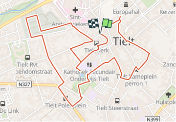
Trail On foot of 3.4 km to be discovered at Flanders, West Flanders, Tielt. This trail is proposed by SityTrail - itinéraires balisés pédestres.
Description
Met de erfgoedwandelroute Tielt ga je op zoek naar sporen van de toonaangevende families en Poolse troepen die her en der in de stad worden herdacht.
Positioning
Country:
Belgium
Region :
Flanders
Department/Province :
West Flanders
Municipality :
Tielt
Location:
Tielt
Start:(Dec)
Start:(UTM)
522824 ; 5649951 (31U) N.
Comments
Trails nearby
![Trail Walking Tielt - GR128. Tielt-Deinze - Photo](https://media.geolcdn.com/t/375/260/99c98151-ac81-4ef1-a55d-a335a68b531a.jpg&format=jpg&maxdim=2)
![Walking Walking](https://static1.geolcdn.com/sitytour/trail-icons/101.png)
GR128. Tielt-Deinze
Walking
Very difficult
Tielt,
Flanders,
West Flanders,
Belgium
![](/images/other/stat-length.png)
23 km | 25 km-effort
4h 47min
![](https://static1.geolcdn.com/siteimages/upload/files/16400158638029165_repeat_loop_refresh_sync_direction_icon.png)
No
![Trail On foot Tielt - Aarsele (bus van uit Tielt) - Tielt - Photo](https://media.geolcdn.com/t/375/260/ext.jpg?maxdim=2&url=https%3A%2F%2Fstatic1.geolcdn.com%2Fsiteimages%2Fupload%2Ffiles%2F1545311037marcheuse_200dpi.jpg)
![On foot On foot](https://static1.geolcdn.com/sitytour/trail-icons/100.png)
Aarsele (bus van uit Tielt) - Tielt
On foot
Easy
Tielt,
Flanders,
West Flanders,
Belgium
![](/images/other/stat-length.png)
12.8 km | 14.1 km-effort
2h 58min
![](https://static1.geolcdn.com/siteimages/upload/files/16400158638029165_repeat_loop_refresh_sync_direction_icon.png)
No
![Trail Walking Tielt - Tielt Poelbergwandeling - 6 km RT - Photo](https://media.geolcdn.com/t/375/260/ext.jpg?maxdim=2&url=https%3A%2F%2Fstatic1.geolcdn.com%2Fsiteimages%2Fupload%2Ffiles%2F1553511878bg_sport_marche.png)
![Walking Walking](https://static1.geolcdn.com/sitytour/trail-icons/101.png)
Tielt Poelbergwandeling - 6 km RT
Walking
Very easy
Tielt,
Flanders,
West Flanders,
Belgium
![](/images/other/stat-length.png)
6.2 km | 6.9 km-effort
Unknown
![](https://static1.geolcdn.com/siteimages/upload/files/16400158638029165_repeat_loop_refresh_sync_direction_icon.png)
Yes
![Trail Other activity Tielt - CabrioRoute in het Tieltse - Photo](https://media.geolcdn.com/t/375/260/ext.jpg?maxdim=2&url=https%3A%2F%2Fstatic1.geolcdn.com%2Fsiteimages%2Fupload%2Ffiles%2F1545311037marcheuse_200dpi.jpg)
![Other activity Other activity](https://static1.geolcdn.com/sitytour/trail-icons/900.png)
CabrioRoute in het Tieltse
Other activity
Very easy
Tielt,
Flanders,
West Flanders,
Belgium
![](/images/other/stat-length.png)
234 km | 251 km-effort
Unknown
![](https://static1.geolcdn.com/siteimages/upload/files/16400158638029165_repeat_loop_refresh_sync_direction_icon.png)
Yes
![Trail Walking Tielt - 80.502 Aalter - Tielt - Photo](https://media.geolcdn.com/t/375/260/ext.jpg?maxdim=2&url=https%3A%2F%2Fstatic1.geolcdn.com%2Fsiteimages%2Fupload%2Ffiles%2F1553511878bg_sport_marche.png)
![Walking Walking](https://static1.geolcdn.com/sitytour/trail-icons/101.png)
80.502 Aalter - Tielt
Walking
Medium
Tielt,
Flanders,
West Flanders,
Belgium
![](/images/other/stat-length.png)
20 km | 21 km-effort
4h 49min
![](https://static1.geolcdn.com/siteimages/upload/files/16400158638029165_repeat_loop_refresh_sync_direction_icon.png)
No
![Trail Walking Tielt - 80.736 Tielt - Schuifenkapelle - Photo](https://media.geolcdn.com/t/375/260/ext.jpg?maxdim=2&url=https%3A%2F%2Fstatic1.geolcdn.com%2Fsiteimages%2Fupload%2Ffiles%2F1553511878bg_sport_marche.png)
![Walking Walking](https://static1.geolcdn.com/sitytour/trail-icons/101.png)
80.736 Tielt - Schuifenkapelle
Walking
Easy
Tielt,
Flanders,
West Flanders,
Belgium
![](/images/other/stat-length.png)
17.6 km | 19.1 km-effort
4h 19min
![](https://static1.geolcdn.com/siteimages/upload/files/16400158638029165_repeat_loop_refresh_sync_direction_icon.png)
Yes
![Trail Walking Tielt - 69.189 Tielt - Tieltse Poelberg - Photo](https://media.geolcdn.com/t/375/260/ext.jpg?maxdim=2&url=https%3A%2F%2Fstatic1.geolcdn.com%2Fsiteimages%2Fupload%2Ffiles%2F1553511878bg_sport_marche.png)
![Walking Walking](https://static1.geolcdn.com/sitytour/trail-icons/101.png)
69.189 Tielt - Tieltse Poelberg
Walking
Easy
Tielt,
Flanders,
West Flanders,
Belgium
![](/images/other/stat-length.png)
12.8 km | 14.2 km-effort
3h 12min
![](https://static1.geolcdn.com/siteimages/upload/files/16400158638029165_repeat_loop_refresh_sync_direction_icon.png)
Yes
![Trail Walking Dentergem - Meikensbos - Photo](https://media.geolcdn.com/t/375/260/ext.jpg?maxdim=2&url=https%3A%2F%2Fstatic1.geolcdn.com%2Fsiteimages%2Fupload%2Ffiles%2F1553511878bg_sport_marche.png)
![Walking Walking](https://static1.geolcdn.com/sitytour/trail-icons/101.png)
Meikensbos
Walking
Very easy
Dentergem,
Flanders,
West Flanders,
Belgium
![](/images/other/stat-length.png)
3.3 km | 3.6 km-effort
52min
![](https://static1.geolcdn.com/siteimages/upload/files/16400158638029165_repeat_loop_refresh_sync_direction_icon.png)
Yes