![](/images/other/stat-length.png)
![Trail On foot Diepenbeek - De Maten rood - Photo](https://media.geolcdn.com/t/1900/400/9980fe5d-a221-412a-85ce-57156ea9267e.jpeg&format=pjpeg&maxdim=2)
De Maten rood
SityTrail - itinéraires balisés pédestres
Tous les sentiers balisés d’Europe GUIDE+
![Length](/images/other/stat-length.png)
Length
10.2 km
![Max alt](https://static1.geolcdn.com/siteimages/upload/files/1508320355ic_sort_altitude_max_24dp.png)
Max alt
59 m
![Uphill gradient](https://static1.geolcdn.com/siteimages/upload/files/1508320355ic_sort_den_pos_24dp.png)
Uphill gradient
69 m
![Km-Effort](/images/other/stat-length.png)
Km-Effort
11.1 km
![Min alt](https://static1.geolcdn.com/siteimages/upload/files/1508320355ic_sort_altitude_min_24dp.png)
Min alt
42 m
![Downhill gradient](https://static1.geolcdn.com/siteimages/upload/files/1508320355ic_sort_den_neg_24dp.png)
Downhill gradient
70 m
![Boucle](https://static1.geolcdn.com/siteimages/upload/files/16400158638029165_repeat_loop_refresh_sync_direction_icon.png)
Boucle
Yes
Signpost
Creation date :
2022-02-09 15:20:43.191
Updated on :
2022-02-09 18:01:38.714
![On foot](https://static1.geolcdn.com/sitytour/trail-icons/100.png)
2h31
Difficulty : Easy
![Scan this QR Code to open this trail in the SityTrail application](https://capi.geolives.com/qq0zvz2zws4bq2lad0pu/sitytour/trails/3083554/qr.png?size=200)
FREE GPS app for hiking
About
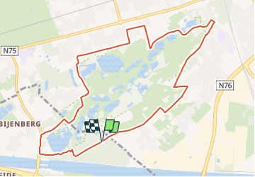
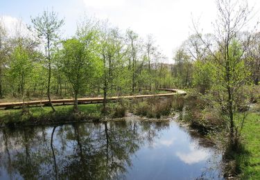
Trail On foot of 10.2 km to be discovered at Flanders, Limburg, Diepenbeek. This trail is proposed by SityTrail - itinéraires balisés pédestres.
Description
Trail created by RLLK Regionaal Landschap Lage Kempen.
Symbol: triangle
Positioning
Country:
Belgium
Region :
Flanders
Department/Province :
Limburg
Municipality :
Diepenbeek
Location:
Unknown
Start:(Dec)
Start:(UTM)
671869 ; 5646203 (31U) N.
Comments
Trails nearby
![Trail Walking Genk - Promenade vers la piste dans l'eau, dans le magnifique domaine de Bokrijk - Photo](https://media.geolcdn.com/t/375/260/45cc0ed2-db94-4d5d-a7c6-1096a930a2ab.jpg&format=jpg&maxdim=2)
![Walking Walking](https://static1.geolcdn.com/sitytour/trail-icons/101.png)
Promenade vers la piste dans l'eau, dans le magnifique domaine de Bokrijk
Walking
Easy
(3)
Genk,
Flanders,
Limburg,
Belgium
![](/images/other/stat-length.png)
4.1 km | 4.6 km-effort
1h 2min
![](https://static1.geolcdn.com/siteimages/upload/files/16400158638029165_repeat_loop_refresh_sync_direction_icon.png)
Yes
![Trail Walking Diepenbeek - La vallée du Démer - La réserve naturelle Dorpsbemden à Diepenbeek - Photo](https://media.geolcdn.com/t/375/260/831c90b3-6b69-4442-bd2d-357552ece2e5.jpeg&format=jpg&maxdim=2)
![Walking Walking](https://static1.geolcdn.com/sitytour/trail-icons/101.png)
La vallée du Démer - La réserve naturelle Dorpsbemden à Diepenbeek
Walking
Easy
Diepenbeek,
Flanders,
Limburg,
Belgium
![](/images/other/stat-length.png)
3.1 km | 3.3 km-effort
45min
![](https://static1.geolcdn.com/siteimages/upload/files/16400158638029165_repeat_loop_refresh_sync_direction_icon.png)
Yes
![Trail Walking Diepenbeek - La vallée du Démer - Le ruisseau Dauten et les Dautewijers à Diepenbeek - Photo](https://media.geolcdn.com/t/375/260/ff431e14-a2e4-4401-9193-e96799f79a9a.jpeg&format=jpg&maxdim=2)
![Walking Walking](https://static1.geolcdn.com/sitytour/trail-icons/101.png)
La vallée du Démer - Le ruisseau Dauten et les Dautewijers à Diepenbeek
Walking
Easy
Diepenbeek,
Flanders,
Limburg,
Belgium
![](/images/other/stat-length.png)
5.4 km | 5.8 km-effort
1h 19min
![](https://static1.geolcdn.com/siteimages/upload/files/16400158638029165_repeat_loop_refresh_sync_direction_icon.png)
Yes
![Trail On foot Diepenbeek - Lange afstandstocht - Photo](https://media.geolcdn.com/t/375/260/c0f28296-bcff-4fe2-9db4-902c2464ce24.jpeg&format=jpg&maxdim=2)
![On foot On foot](https://static1.geolcdn.com/sitytour/trail-icons/100.png)
Lange afstandstocht
On foot
Easy
Diepenbeek,
Flanders,
Limburg,
Belgium
![](/images/other/stat-length.png)
16.5 km | 17.8 km-effort
4h 2min
![](https://static1.geolcdn.com/siteimages/upload/files/16400158638029165_repeat_loop_refresh_sync_direction_icon.png)
Yes
![Trail On foot Genk - Zillebos blauwe ruit - Photo](https://media.geolcdn.com/t/375/260/6925453e-2323-4e41-8380-50ced4fee93a.jpeg&format=jpg&maxdim=2)
![On foot On foot](https://static1.geolcdn.com/sitytour/trail-icons/100.png)
Zillebos blauwe ruit
On foot
Easy
Genk,
Flanders,
Limburg,
Belgium
![](/images/other/stat-length.png)
4.2 km | 4.9 km-effort
1h 7min
![](https://static1.geolcdn.com/siteimages/upload/files/16400158638029165_repeat_loop_refresh_sync_direction_icon.png)
Yes
![Trail On foot Genk - Zillebos rode driehoek - Photo](https://media.geolcdn.com/t/375/260/6925453e-2323-4e41-8380-50ced4fee93a.jpeg&format=jpg&maxdim=2)
![On foot On foot](https://static1.geolcdn.com/sitytour/trail-icons/100.png)
Zillebos rode driehoek
On foot
Easy
Genk,
Flanders,
Limburg,
Belgium
![](/images/other/stat-length.png)
5.5 km | 6.4 km-effort
1h 27min
![](https://static1.geolcdn.com/siteimages/upload/files/16400158638029165_repeat_loop_refresh_sync_direction_icon.png)
Yes
![Trail On foot Genk - De Maten oranje - Photo](https://media.geolcdn.com/t/375/260/5daa36df-5a45-46f0-9e87-234b3c303469.jpeg&format=jpg&maxdim=2)
![On foot On foot](https://static1.geolcdn.com/sitytour/trail-icons/100.png)
![Trail On foot Genk - Bokrijk Gele zeshoek (voor rolstoel/buggy) - Photo](https://media.geolcdn.com/t/375/260/abfb207d-dc7b-4a70-b673-1e7d6075a286.jpeg&format=jpg&maxdim=2)
![On foot On foot](https://static1.geolcdn.com/sitytour/trail-icons/100.png)
Bokrijk Gele zeshoek (voor rolstoel/buggy)
On foot
Easy
Genk,
Flanders,
Limburg,
Belgium
![](/images/other/stat-length.png)
4.1 km | 4.7 km-effort
1h 3min
![](https://static1.geolcdn.com/siteimages/upload/files/16400158638029165_repeat_loop_refresh_sync_direction_icon.png)
Yes
![Trail On foot Hasselt - Kiewit Wildernis route - Photo](https://media.geolcdn.com/t/375/260/3dbc744d-9453-4105-ac17-d803e722e0e9.jpeg&format=jpg&maxdim=2)
![On foot On foot](https://static1.geolcdn.com/sitytour/trail-icons/100.png)
Kiewit Wildernis route
On foot
Easy
Hasselt,
Flanders,
Limburg,
Belgium
![](/images/other/stat-length.png)
3.3 km | 3.7 km-effort
49min
![](https://static1.geolcdn.com/siteimages/upload/files/16400158638029165_repeat_loop_refresh_sync_direction_icon.png)
Yes
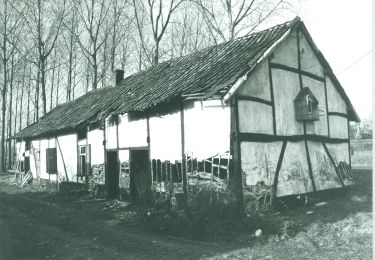
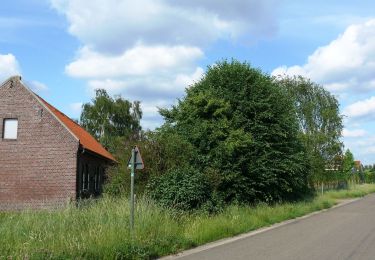
Cet itinéraire vous fait découvrir la magnifique réserve naturelle située entre Genk et Diepenbeek. Vous longez les nombreux étangs du Maten jusqu'au Diepenbekerbos. ➡️ https://www.wandeleninlimburg.be/nl/routes/3377708/ 🐕 Chien ok sur ce parcours. 📍Point de départ : Slagmolenweg 76, Genk