Trail On foot Veurne - Ringslot wandelroute - Photo

Ringslot wandelroute

Tous les sentiers balisés d’Europe GUIDE+

© OpenStreetMap contributors
Length
Length
9.1 km
Max alt
Max alt
8 m
Uphill gradient
Uphill gradient
23 m
Km-Effort
Km-Effort  
9.5 km
Min alt
Min alt
-3 m
Downhill gradient
Downhill gradient
23 m
Boucle
Boucle
Yes
Signpost
Signpost
Creation date :
2022-02-09 15:08:11.621
Updated on :
2022-02-09 17:54:20.055

(0 Reviews)

On foot
On foot
2h08
Difficulty : Easy

Scan this QR Code to open this trail in the SityTrail application

FREE GPS app for hiking

Logo SityTrail SityTrail

IGN / Geographical institutes

Download SityTrail from the App Store Download SityTrail from Google Play

Logo SityTrail SityTrail World

The world is yours!

Download SityTrail from the App Store Download SityTrail from Google Play Download SityTrail on Huawei AppGallery

About

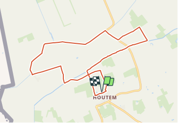
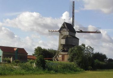
Trail On foot of 9.1 km to be discovered at Flanders, West Flanders, Veurne. This trail is proposed by SityTrail - itinéraires balisés pédestres.

Description

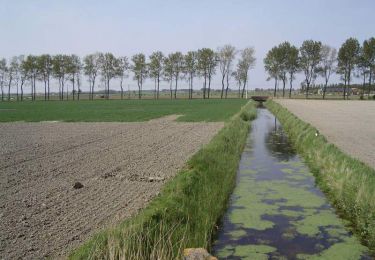
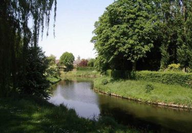
Deze route doet het grensgebied tussen polder en Houtland aan. Vanuit de Veurnse deelgemeente Houtem wandel je naar De Moeren. Het landschap wordt gekenmerkt door de eeuwenoude rechthoekige kavelstructuur en het rechtlijnig grachten- en wegenpatroon. De terugweg leidt via de Buitenmoeren en de Bergenvaart.

Elevation profile

Photos

Positioning

Country:
Belgium
Region :
Flanders
Department/Province :
West Flanders
Municipality :
Veurne
Location:
Houtem
Start:(UTM)
472422 ; 5651261 (31U) N.

Trails nearby

Trail Cycle Hondschoote - La route du lin 2014 - Hondschoote - Photo
Cycle
tracegps

Cycle

Medium
Hondschoote, Hauts-de-France, Nord, France
28 km | 30 km-effort
2h 0min
Yes
Trail Cycle Hondschoote - La route du lin 2013 - Hondschoote - Photo
Cycle
tracegps

Cycle

Easy
Hondschoote, Hauts-de-France, Nord, France
35 km | 37 km-effort
2h 0min
Yes
Trail Mountain bike Hondschoote - La route du lin 2013 - Hondschoote - Photo
Mountain bike
tracegps

Mountain bike

Easy
Hondschoote, Hauts-de-France, Nord, France
35 km | 37 km-effort
3h 0min
Yes
Trail Cycle Hondschoote - La route du lin 2011 - Hondschoote  - Photo
Cycle
tracegps

Cycle

Easy
(1)
Hondschoote, Hauts-de-France, Nord, France
33 km | 34 km-effort
2h 0min
Yes
Trail Mountain bike Hondschoote - La route du lin 2011 - Hondschoote  - Photo
Mountain bike
tracegps

Mountain bike

Easy
Hondschoote, Hauts-de-France, Nord, France
33 km | 34 km-effort
3h 0min
Yes
Trail Walking Hondschoote - Circuit des chapelles (Hondschoote) - Photo
Walking
tracegps

Walking

Difficult
Hondschoote, Hauts-de-France, Nord, France
19 km | 20 km-effort
4h 45min
Yes
Trail Walking Ghyvelde - Les Moëres - Photo
Walking
tracegps

Walking

Difficult
Ghyvelde, Hauts-de-France, Nord, France
15.1 km | 15.6 km-effort
3h 45min
Yes
Trail Walking Hondschoote - Circuit des Anguilles - Hondschoote - Photo
Walking
tracegps

Walking

Medium
(2)
Hondschoote, Hauts-de-France, Nord, France
9.4 km | 9.8 km-effort
2h 15min
Yes
Trail Cycle Hondschoote - Circuit des Teillages - Hondschoote - Photo
Cycle
tracegps

Cycle

Difficult
Hondschoote, Hauts-de-France, Nord, France
107 km | 112 km-effort
5h 30min
Yes


Close
My subscriptions