![](/images/other/stat-length.png)
![Trail On foot Wervik - Boerenkrijg wandelroute - Photo](https://media.geolcdn.com/t/1900/400/f7c6ea9e-eda8-4a64-a399-c259eeda76a1.jpeg&format=pjpeg&maxdim=2)
Boerenkrijg wandelroute
SityTrail - itinéraires balisés pédestres
Tous les sentiers balisés d’Europe GUIDE+
![Length](/images/other/stat-length.png)
Length
8.1 km
![Max alt](https://static1.geolcdn.com/siteimages/upload/files/1508320355ic_sort_altitude_max_24dp.png)
Max alt
44 m
![Uphill gradient](https://static1.geolcdn.com/siteimages/upload/files/1508320355ic_sort_den_pos_24dp.png)
Uphill gradient
65 m
![Km-Effort](/images/other/stat-length.png)
Km-Effort
8.9 km
![Min alt](https://static1.geolcdn.com/siteimages/upload/files/1508320355ic_sort_altitude_min_24dp.png)
Min alt
18 m
![Downhill gradient](https://static1.geolcdn.com/siteimages/upload/files/1508320355ic_sort_den_neg_24dp.png)
Downhill gradient
63 m
![Boucle](https://static1.geolcdn.com/siteimages/upload/files/16400158638029165_repeat_loop_refresh_sync_direction_icon.png)
Boucle
Yes
Signpost
Creation date :
2022-02-09 15:07:53.769
Updated on :
2022-02-09 17:54:09.084
![On foot](https://static1.geolcdn.com/sitytour/trail-icons/100.png)
2h01
Difficulty : Easy
![Scan this QR Code to open this trail in the SityTrail application](https://capi.geolives.com/qq0zvz2zws4bq2lad0pu/sitytour/trails/3083362/qr.png?size=200)
FREE GPS app for hiking
About
Trail On foot of 8.1 km to be discovered at Flanders, West Flanders, Wervik. This trail is proposed by SityTrail - itinéraires balisés pédestres.
Description
Deze wandelrouteroute voert je doorheen het glooiend landschap van de Tabaksstreek.
Positioning
Country:
Belgium
Region :
Flanders
Department/Province :
West Flanders
Municipality :
Wervik
Location:
Geluwe
Start:(Dec)
Start:(UTM)
504164 ; 5632311 (31U) N.
Comments
Trails nearby
![Trail On foot Wervik - Kruiseke wandelroute - Photo](https://media.geolcdn.com/t/375/260/4700ca75-a123-4e08-bea6-76f1c1794d28.jpeg&format=jpg&maxdim=2)
![On foot On foot](https://static1.geolcdn.com/sitytour/trail-icons/100.png)
Kruiseke wandelroute
On foot
Easy
Wervik,
Flanders,
West Flanders,
Belgium
![](/images/other/stat-length.png)
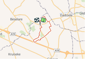
6.3 km | 7 km-effort
1h 35min
![](https://static1.geolcdn.com/siteimages/upload/files/16400158638029165_repeat_loop_refresh_sync_direction_icon.png)
Yes
![Trail On foot Zonnebeke - Heksen wandelroute - Photo](https://media.geolcdn.com/t/375/260/a9121705-01d0-4e7a-845d-18305b5164cf.jpeg&format=jpg&maxdim=2)
![On foot On foot](https://static1.geolcdn.com/sitytour/trail-icons/100.png)
Heksen wandelroute
On foot
Easy
Zonnebeke,
Flanders,
West Flanders,
Belgium
![](/images/other/stat-length.png)
8.1 km | 8.9 km-effort
2h 2min
![](https://static1.geolcdn.com/siteimages/upload/files/16400158638029165_repeat_loop_refresh_sync_direction_icon.png)
Yes
![Trail On foot Moorslede - Pompeschitters wandelroute - Photo](https://media.geolcdn.com/t/375/260/41739a4b-4e57-4665-b5a5-a88f301a11f1.jpeg&format=jpg&maxdim=2)
![On foot On foot](https://static1.geolcdn.com/sitytour/trail-icons/100.png)
Pompeschitters wandelroute
On foot
Easy
Moorslede,
Flanders,
West Flanders,
Belgium
![](/images/other/stat-length.png)
9 km | 9.8 km-effort
2h 13min
![](https://static1.geolcdn.com/siteimages/upload/files/16400158638029165_repeat_loop_refresh_sync_direction_icon.png)
Yes
![Trail Equestrian Wervik - menokke Wervik - Photo](https://media.geolcdn.com/t/375/260/ext.jpg?maxdim=2&url=https%3A%2F%2Fstatic1.geolcdn.com%2Fsiteimages%2Fupload%2Ffiles%2F1524743154cheval.jpg)
![Equestrian Equestrian](https://static1.geolcdn.com/sitytour/trail-icons/300.png)
menokke Wervik
Equestrian
Very easy
Wervik,
Flanders,
West Flanders,
Belgium
![](/images/other/stat-length.png)
12 km | 13 km-effort
3h 21min
![](https://static1.geolcdn.com/siteimages/upload/files/16400158638029165_repeat_loop_refresh_sync_direction_icon.png)
Yes
![Trail Walking Comines-Warneton - Kruiseke wandelen - Photo](https://media.geolcdn.com/t/375/260/ext.jpg?maxdim=2&url=https%3A%2F%2Fstatic1.geolcdn.com%2Fsiteimages%2Fupload%2Ffiles%2F1553511878bg_sport_marche.png)
![Walking Walking](https://static1.geolcdn.com/sitytour/trail-icons/101.png)
Kruiseke wandelen
Walking
Comines-Warneton,
Wallonia,
Hainaut,
Belgium
![](/images/other/stat-length.png)
6.7 km | 7.4 km-effort
2h 3min
![](https://static1.geolcdn.com/siteimages/upload/files/16400158638029165_repeat_loop_refresh_sync_direction_icon.png)
Yes
![Trail Cycle Moorslede - f-belgie-bevevaartroute - Photo](https://media.geolcdn.com/t/375/260/ext.jpg?maxdim=2&url=https%3A%2F%2Fstatic1.geolcdn.com%2Fsiteimages%2Fupload%2Ffiles%2F1524743154velo.jpg)
![Cycle Cycle](https://static1.geolcdn.com/sitytour/trail-icons/200.png)
f-belgie-bevevaartroute
Cycle
Very easy
Moorslede,
Flanders,
West Flanders,
Belgium
![](/images/other/stat-length.png)
40 km | 43 km-effort
Unknown
![](https://static1.geolcdn.com/siteimages/upload/files/16400158638029165_repeat_loop_refresh_sync_direction_icon.png)
Yes
![Trail Cycle Wevelgem - Belgie - Bedevaartroute - Photo](https://media.geolcdn.com/t/375/260/ext.jpg?maxdim=2&url=https%3A%2F%2Fstatic1.geolcdn.com%2Fsiteimages%2Fupload%2Ffiles%2F1524743154velo.jpg)
![Cycle Cycle](https://static1.geolcdn.com/sitytour/trail-icons/200.png)
Belgie - Bedevaartroute
Cycle
Very easy
Wevelgem,
Flanders,
West Flanders,
Belgium
![](/images/other/stat-length.png)
40 km | 43 km-effort
Unknown
![](https://static1.geolcdn.com/siteimages/upload/files/16400158638029165_repeat_loop_refresh_sync_direction_icon.png)
Yes
![Trail Walking Moorslede - w-belgie-pompeschitterswandelpad - Photo](https://media.geolcdn.com/t/375/260/ext.jpg?maxdim=2&url=https%3A%2F%2Fstatic1.geolcdn.com%2Fsiteimages%2Fupload%2Ffiles%2F1553511878bg_sport_marche.png)
![Walking Walking](https://static1.geolcdn.com/sitytour/trail-icons/101.png)
w-belgie-pompeschitterswandelpad
Walking
Very easy
Moorslede,
Flanders,
West Flanders,
Belgium
![](/images/other/stat-length.png)
8.7 km | 9.5 km-effort
Unknown
![](https://static1.geolcdn.com/siteimages/upload/files/16400158638029165_repeat_loop_refresh_sync_direction_icon.png)
Yes
![Trail Walking Wervik - w-belgie-kruiseke-wandelroute - Photo](https://media.geolcdn.com/t/375/260/ext.jpg?maxdim=2&url=https%3A%2F%2Fstatic1.geolcdn.com%2Fsiteimages%2Fupload%2Ffiles%2F1553511878bg_sport_marche.png)
![Walking Walking](https://static1.geolcdn.com/sitytour/trail-icons/101.png)
w-belgie-kruiseke-wandelroute
Walking
Very easy
Wervik,
Flanders,
West Flanders,
Belgium
![](/images/other/stat-length.png)
6.2 km | 6.9 km-effort
Unknown
![](https://static1.geolcdn.com/siteimages/upload/files/16400158638029165_repeat_loop_refresh_sync_direction_icon.png)
Yes