![](/images/other/stat-length.png)
![Trail On foot Oostkamp - Meersen wandelroute - Photo](https://media.geolcdn.com/t/1900/400/f2c5a60a-a73e-4cc6-a91f-c7d48fe602b2.jpeg&format=pjpeg&maxdim=2)
Meersen wandelroute
SityTrail - itinéraires balisés pédestres
Tous les sentiers balisés d’Europe GUIDE+
![Length](/images/other/stat-length.png)
Length
7 km
![Max alt](https://static1.geolcdn.com/siteimages/upload/files/1508320355ic_sort_altitude_max_24dp.png)
Max alt
16 m
![Uphill gradient](https://static1.geolcdn.com/siteimages/upload/files/1508320355ic_sort_den_pos_24dp.png)
Uphill gradient
61 m
![Km-Effort](/images/other/stat-length.png)
Km-Effort
7.8 km
![Min alt](https://static1.geolcdn.com/siteimages/upload/files/1508320355ic_sort_altitude_min_24dp.png)
Min alt
-1 m
![Downhill gradient](https://static1.geolcdn.com/siteimages/upload/files/1508320355ic_sort_den_neg_24dp.png)
Downhill gradient
60 m
![Boucle](https://static1.geolcdn.com/siteimages/upload/files/16400158638029165_repeat_loop_refresh_sync_direction_icon.png)
Boucle
Yes
Signpost
Creation date :
2022-02-09 15:07:52.83
Updated on :
2022-02-09 17:54:08.469
![On foot](https://static1.geolcdn.com/sitytour/trail-icons/100.png)
1h46
Difficulty : Easy
![Scan this QR Code to open this trail in the SityTrail application](https://capi.geolives.com/qq0zvz2zws4bq2lad0pu/sitytour/trails/3083361/qr.png?size=200)
FREE GPS app for hiking
About
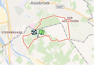
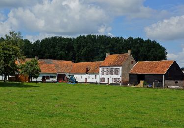
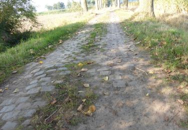
Trail On foot of 7 km to be discovered at Flanders, West Flanders, Oostkamp. This trail is proposed by SityTrail - itinéraires balisés pédestres.
Description
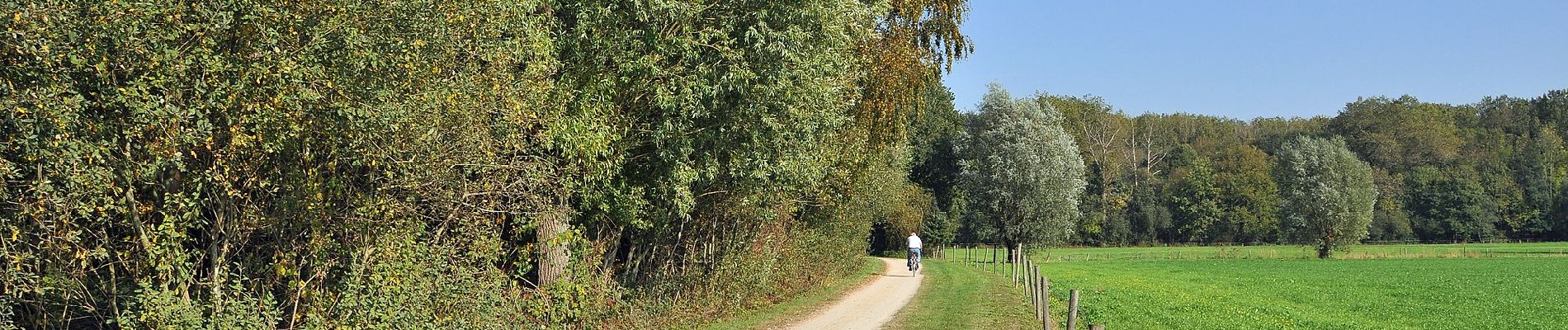
Op de Meersenwandelroute staat het landschap van de Assebroekse Meersen centraal. Dit 420 ha beschermd gebied ligt op de grens met Brugge, Beernem en Oostkamp.
Positioning
Country:
Belgium
Region :
Flanders
Department/Province :
West Flanders
Municipality :
Oostkamp
Location:
Oostkamp
Start:(Dec)
Start:(UTM)
517640 ; 5669896 (31U) N.
Comments
Trails nearby
![Trail Walking Bruges - The Best of Bruges - Photo](https://media.geolcdn.com/t/375/260/ext.jpg?maxdim=2&url=https%3A%2F%2Fservices.sitytrail.com%2FGeolivesWS%2FDownloadMedia.ashx%3FTrailID%3D544186%26Media%3D180b77e7-3bf1-4890-afa8-613a20f0125b.jpg)
![Walking Walking](https://static1.geolcdn.com/sitytour/trail-icons/101.png)
The Best of Bruges
Walking
Very easy
(4)
Bruges,
Flanders,
West Flanders,
Belgium
![](/images/other/stat-length.png)
4.3 km | 4.6 km-effort
2h 0min
![](https://static1.geolcdn.com/siteimages/upload/files/16400158638029165_repeat_loop_refresh_sync_direction_icon.png)
Yes
![Trail Walking Bruges - Bruges, une ville fière de son Patrimoine mondial - Photo](https://media.geolcdn.com/t/375/260/ext.jpg?maxdim=2&url=https%3A%2F%2Fservices.sitytrail.com%2FGeolivesWS%2FDownloadMedia.ashx%3FTrailID%3D66330%26Media%3D3ea5f1bf-5086-4b42-b388-3be547d8a98c.jpg)
![Walking Walking](https://static1.geolcdn.com/sitytour/trail-icons/101.png)
Bruges, une ville fière de son Patrimoine mondial
Walking
Easy
(3)
Bruges,
Flanders,
West Flanders,
Belgium
![](/images/other/stat-length.png)
3.2 km | 3.4 km-effort
Unknown
![](https://static1.geolcdn.com/siteimages/upload/files/16400158638029165_repeat_loop_refresh_sync_direction_icon.png)
No
![Trail On foot Bruges - Drie Kastelen Wandelroute - Photo](https://media.geolcdn.com/t/375/260/8ba757f9-e732-4c67-ba6a-cb7a9261b76e.jpeg&format=jpg&maxdim=2)
![On foot On foot](https://static1.geolcdn.com/sitytour/trail-icons/100.png)
Drie Kastelen Wandelroute
On foot
Easy
Bruges,
Flanders,
West Flanders,
Belgium
![](/images/other/stat-length.png)
12.1 km | 14 km-effort
3h 11min
![](https://static1.geolcdn.com/siteimages/upload/files/16400158638029165_repeat_loop_refresh_sync_direction_icon.png)
Yes
![Trail On foot Oostkamp - Torenhofpad - Photo](https://media.geolcdn.com/t/375/260/528b7473-50d0-4d67-9290-c784fca8c422.jpeg&format=jpg&maxdim=2)
![On foot On foot](https://static1.geolcdn.com/sitytour/trail-icons/100.png)
Torenhofpad
On foot
Easy
Oostkamp,
Flanders,
West Flanders,
Belgium
![](/images/other/stat-length.png)
8.4 km | 9.3 km-effort
2h 6min
![](https://static1.geolcdn.com/siteimages/upload/files/16400158638029165_repeat_loop_refresh_sync_direction_icon.png)
Yes
![Trail On foot Damme - Ryckevelde - Photo](https://media.geolcdn.com/t/375/260/3c2851c2-3524-4e86-85e2-2de1bccce854.jpeg&format=jpg&maxdim=2)
![On foot On foot](https://static1.geolcdn.com/sitytour/trail-icons/100.png)
![Trail On foot Beernem - Beverhoutsveld wandelpad - Photo](https://media.geolcdn.com/t/375/260/5dc092da-939c-4ed9-8e00-3f0317838ae0.jpeg&format=jpg&maxdim=2)
![On foot On foot](https://static1.geolcdn.com/sitytour/trail-icons/100.png)
Beverhoutsveld wandelpad
On foot
Easy
Beernem,
Flanders,
West Flanders,
Belgium
![](/images/other/stat-length.png)
15.2 km | 16.3 km-effort
3h 42min
![](https://static1.geolcdn.com/siteimages/upload/files/16400158638029165_repeat_loop_refresh_sync_direction_icon.png)
Yes
![Trail Walking Bruges - Bruges - Photo](https://media.geolcdn.com/t/375/260/c021ff3f-e73e-4620-bed9-0e65728f669d.jpg&format=jpg&maxdim=2)
![Walking Walking](https://static1.geolcdn.com/sitytour/trail-icons/101.png)
Bruges
Walking
Very easy
Bruges,
Flanders,
West Flanders,
Belgium
![](/images/other/stat-length.png)
12.1 km | 12.9 km-effort
3h 1min
![](https://static1.geolcdn.com/siteimages/upload/files/16400158638029165_repeat_loop_refresh_sync_direction_icon.png)
Yes
![Trail Walking Bruges - GR 129 : Brugge > Beernem - Photo](https://media.geolcdn.com/t/375/260/ext.jpg?maxdim=2&url=https%3A%2F%2Fstatic1.geolcdn.com%2Fsiteimages%2Fupload%2Ffiles%2F1553511878bg_sport_marche.png)
![Walking Walking](https://static1.geolcdn.com/sitytour/trail-icons/101.png)
GR 129 : Brugge > Beernem
Walking
Very easy
(3)
Bruges,
Flanders,
West Flanders,
Belgium
![](/images/other/stat-length.png)
20 km | 22 km-effort
4h 50min
![](https://static1.geolcdn.com/siteimages/upload/files/16400158638029165_repeat_loop_refresh_sync_direction_icon.png)
No
![Trail Walking Bruges - Brugge langs beddingen - 5 km RT - Photo](https://media.geolcdn.com/t/375/260/ext.jpg?maxdim=2&url=https%3A%2F%2Fstatic1.geolcdn.com%2Fsiteimages%2Fupload%2Ffiles%2F1553511878bg_sport_marche.png)
![Walking Walking](https://static1.geolcdn.com/sitytour/trail-icons/101.png)
Brugge langs beddingen - 5 km RT
Walking
Very easy
(2)
Bruges,
Flanders,
West Flanders,
Belgium
![](/images/other/stat-length.png)
5 km | 5.2 km-effort
Unknown
![](https://static1.geolcdn.com/siteimages/upload/files/16400158638029165_repeat_loop_refresh_sync_direction_icon.png)
Yes