![](/images/other/stat-length.png)
![Trail On foot Kluisbergen - Entre Kwaremont et Amougies - Photo](https://media.geolcdn.com/t/1900/400/ext.pjpeg?maxdim=2&url=https%3A%2F%2Fpivotmedia.tourismewallonie.be%2FANX-02-000EUL%2FANX-02-000EUL.jpg)
Entre Kwaremont et Amougies
Commissariat général au Tourisme
Randonnées du CGT GUIDE+
![Length](/images/other/stat-length.png)
Length
9.1 km
![Max alt](https://static1.geolcdn.com/siteimages/upload/files/1508320355ic_sort_altitude_max_24dp.png)
Max alt
140 m
![Uphill gradient](https://static1.geolcdn.com/siteimages/upload/files/1508320355ic_sort_den_pos_24dp.png)
Uphill gradient
218 m
![Km-Effort](/images/other/stat-length.png)
Km-Effort
12 km
![Min alt](https://static1.geolcdn.com/siteimages/upload/files/1508320355ic_sort_altitude_min_24dp.png)
Min alt
23 m
![Downhill gradient](https://static1.geolcdn.com/siteimages/upload/files/1508320355ic_sort_den_neg_24dp.png)
Downhill gradient
216 m
![Boucle](https://static1.geolcdn.com/siteimages/upload/files/16400158638029165_repeat_loop_refresh_sync_direction_icon.png)
Boucle
Yes
Creation date :
2022-02-08 11:35:58.16
Updated on :
2022-02-21 10:17:23.309
![On foot](https://static1.geolcdn.com/sitytour/trail-icons/100.png)
2h43
Difficulty : Easy
![Scan this QR Code to open this trail in the SityTrail application](https://capi.geolives.com/qq0zvz2zws4bq2lad0pu/sitytour/trails/3081362/qr.png?size=200)
FREE GPS app for hiking
About
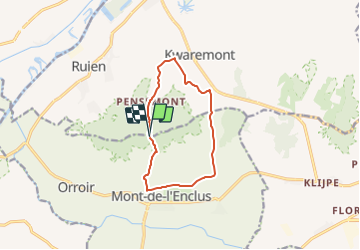
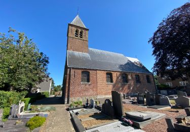
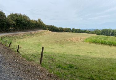
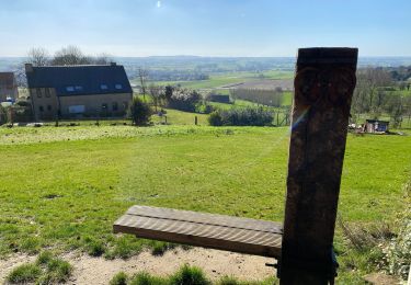
Trail On foot of 9.1 km to be discovered at Flanders, East Flanders, Kluisbergen. This trail is proposed by Commissariat général au Tourisme.
Description
Trail created by Wallonie Picarde (Antenne Tournai) .
Positioning
Country:
Belgium
Region :
Flanders
Department/Province :
East Flanders
Municipality :
Kluisbergen
Location:
Unknown
Start:(Dec)
Start:(UTM)
535766 ; 5623135 (31U) N.
Comments
Trails nearby
![Trail Equestrian Mont-de-l'Enclus - Loop of Mont de l’Enclus - Photo](https://media.geolcdn.com/t/375/260/ext.jpg?maxdim=2&url=https%3A%2F%2Fpivotmedia.tourismewallonie.be%2FANX-02-000EIL%2FANX-02-000EIL.jpg)
![Equestrian Equestrian](https://static1.geolcdn.com/sitytour/trail-icons/300.png)
Loop of Mont de l’Enclus
Equestrian
Very easy
Mont-de-l'Enclus,
Wallonia,
Hainaut,
Belgium
![](/images/other/stat-length.png)
21 km | 24 km-effort
Unknown
![](https://static1.geolcdn.com/siteimages/upload/files/16400158638029165_repeat_loop_refresh_sync_direction_icon.png)
Yes
![Trail Mountain bike Mont-de-l'Enclus - Lanscape around Mont de l’Enclus - Photo](https://media.geolcdn.com/t/375/260/ext.jpg?maxdim=2&url=https%3A%2F%2Fpivotmedia.tourismewallonie.be%2FANX-02-020D-00DS%2FANX-02-020D-00DS.jpg)
![Mountain bike Mountain bike](https://static1.geolcdn.com/sitytour/trail-icons/202.png)
Lanscape around Mont de l’Enclus
Mountain bike
Medium
Mont-de-l'Enclus,
Wallonia,
Hainaut,
Belgium
![](/images/other/stat-length.png)
21 km | 26 km-effort
1h 48min
![](https://static1.geolcdn.com/siteimages/upload/files/16400158638029165_repeat_loop_refresh_sync_direction_icon.png)
Yes
![Trail On foot Mont-de-l'Enclus - Entre Flandre et Wallonie - Photo](https://media.geolcdn.com/t/375/260/ext.jpg?maxdim=2&url=https%3A%2F%2Fpivotmedia.tourismewallonie.be%2FANX-02-000ENY%2FANX-02-000ENY.jpg)
![On foot On foot](https://static1.geolcdn.com/sitytour/trail-icons/100.png)
Entre Flandre et Wallonie
On foot
Medium
(2)
Mont-de-l'Enclus,
Wallonia,
Hainaut,
Belgium
![](/images/other/stat-length.png)
18.6 km | 22 km-effort
5h 4min
![](https://static1.geolcdn.com/siteimages/upload/files/16400158638029165_repeat_loop_refresh_sync_direction_icon.png)
Yes
![Trail On foot Mont-de-l'Enclus - Entre Orroir et Ruien - Photo](https://media.geolcdn.com/t/375/260/ext.jpg?maxdim=2&url=https%3A%2F%2Fpivotmedia.tourismewallonie.be%2FANX-02-000EUH%2FANX-02-000EUH.jpg)
![On foot On foot](https://static1.geolcdn.com/sitytour/trail-icons/100.png)
Entre Orroir et Ruien
On foot
Easy
Mont-de-l'Enclus,
Wallonia,
Hainaut,
Belgium
![](/images/other/stat-length.png)
9 km | 12.5 km-effort
2h 51min
![](https://static1.geolcdn.com/siteimages/upload/files/16400158638029165_repeat_loop_refresh_sync_direction_icon.png)
No
![Trail On foot Mont-de-l'Enclus - The legend of Liedericq - Photo](https://media.geolcdn.com/t/375/260/ext.jpg?maxdim=2&url=https%3A%2F%2Fpivotmedia.tourismewallonie.be%2FANX-02-03XZ-008D%2FANX-02-03XZ-008D.jpg)
![On foot On foot](https://static1.geolcdn.com/sitytour/trail-icons/100.png)
The legend of Liedericq
On foot
Easy
Mont-de-l'Enclus,
Wallonia,
Hainaut,
Belgium
![](/images/other/stat-length.png)
5.6 km | 7.1 km-effort
1h 36min
![](https://static1.geolcdn.com/siteimages/upload/files/16400158638029165_repeat_loop_refresh_sync_direction_icon.png)
Yes
![Trail On foot Mont-de-l'Enclus - The Mont de l’Enclus Landscape Walking Tour - Photo](https://media.geolcdn.com/t/375/260/ext.jpg?maxdim=2&url=https%3A%2F%2Fpivotmedia.tourismewallonie.be%2FANX-02-000ENT%2FANX-02-000ENT.jpg)
![On foot On foot](https://static1.geolcdn.com/sitytour/trail-icons/100.png)
The Mont de l’Enclus Landscape Walking Tour
On foot
Easy
(1)
Mont-de-l'Enclus,
Wallonia,
Hainaut,
Belgium
![](/images/other/stat-length.png)
6.1 km | 8.1 km-effort
1h 50min
![](https://static1.geolcdn.com/siteimages/upload/files/16400158638029165_repeat_loop_refresh_sync_direction_icon.png)
Yes
![Trail Walking Kluisbergen - Zulzeke 15,8 km - Photo](https://media.geolcdn.com/t/375/260/ext.jpg?maxdim=2&url=https%3A%2F%2Fmedia.geolcdn.com%2Ff%2F2d20912f-6269-44c4-8fd6-afa867e882c3.jpg)
![Walking Walking](https://static1.geolcdn.com/sitytour/trail-icons/101.png)
Zulzeke 15,8 km
Walking
Medium
Kluisbergen,
Flanders,
East Flanders,
Belgium
![](/images/other/stat-length.png)
16.6 km | 22 km-effort
4h 33min
![](https://static1.geolcdn.com/siteimages/upload/files/16400158638029165_repeat_loop_refresh_sync_direction_icon.png)
Yes
![Trail Walking Kluisbergen - Ardennes flamandes kluisbergen - Oudenaarde - Photo](https://media.geolcdn.com/t/375/260/ext.jpg?maxdim=2&url=https%3A%2F%2Fmedia.geolcdn.com%2Ff%2F8f12676d-5ae6-4ecf-821c-b8d308f7b3e7.JPG)
![Walking Walking](https://static1.geolcdn.com/sitytour/trail-icons/101.png)
Ardennes flamandes kluisbergen - Oudenaarde
Walking
Very difficult
Kluisbergen,
Flanders,
East Flanders,
Belgium
![](/images/other/stat-length.png)
25 km | 30 km-effort
6h 2min
![](https://static1.geolcdn.com/siteimages/upload/files/16400158638029165_repeat_loop_refresh_sync_direction_icon.png)
No
![Trail Walking Kluisbergen - Kluisbergen Enclus 12 km - Photo](https://media.geolcdn.com/t/375/260/ext.jpg?maxdim=2&url=https%3A%2F%2Fmedia.geolcdn.com%2Ff%2F0141772c-40ce-4f4d-aca2-72d8d316d837.jpg)
![Walking Walking](https://static1.geolcdn.com/sitytour/trail-icons/101.png)
Kluisbergen Enclus 12 km
Walking
Very easy
Kluisbergen,
Flanders,
East Flanders,
Belgium
![](/images/other/stat-length.png)
11.9 km | 15.3 km-effort
3h 57min
![](https://static1.geolcdn.com/siteimages/upload/files/16400158638029165_repeat_loop_refresh_sync_direction_icon.png)
Yes