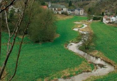

Panorama du Nord Fays
Commissariat général au Tourisme
Randonnées du CGT GUIDE+


1h35
Difficulty : Easy

FREE GPS app for hiking
About
Trail On foot of 5.1 km to be discovered at Wallonia, Namur, Anhée. This trail is proposed by Commissariat général au Tourisme.
Description
Trail created by Vallée de la Meuse Namur-Dinant.
Departure : Place de l'église de Warnant.
Take the path along the cemetery. Continue on the road on the left. At the crossroads of the chapel, turn left. Note the view of the Maison de Pierre farmhouse on your left. After 100m, at the crossroads, turn left into rue du Fond. Turn right into rue Esbrulets. The road curves for 300m. Then take a steep stone path that enters the wood on the right. After 300m, in front of a villa on the right, take the left path. Leave a path that goes down to the left and continue by the chicanes. At the next crossing, go up to the right. At the next T, turn left and reach the panorama of the Nord-Fays. You can see the whole Warnant basin and thus understand its mild microclimate. You are also close to dozens of springs that feed the village. When you arrive near the two lime trees, cross the road and take the path opposite. At the Y, after 300m, turn left and enter the Aujes wood, that is to say the communal toilets. At the Y, after 400m, turn left again and go down a path that becomes a track near the two houses of Plate Pierre. At the road, turn left, then, after 100m, right to go down to the fountain Sainte-Adèle and the chapel ND de Beauraing. At the Union Warnantaise hall, turn right into the rue de la digue and reach the starting point.
Positioning
Comments
Trails nearby

Walking


Walking


Walking


Walking


Walking


Walking


Walking


Walking


Walking


 SityTrail


