Trail On foot Anhée - Tienne de Mwarts - Photo

Tienne de Mwarts

Randonnées du CGT GUIDE+

© OpenStreetMap contributors
Length
Length
5.6 km
Max alt
Max alt
246 m
Uphill gradient
Uphill gradient
116 m
Km-Effort
Km-Effort  
7.1 km
Min alt
Min alt
179 m
Downhill gradient
Downhill gradient
115 m
Boucle
Boucle
Yes
Creation date :
2022-02-08 11:28:35.156
Updated on :
2022-02-21 10:09:44.904

(0 Reviews)

On foot
On foot
1h37
Difficulty : Easy

Scan this QR Code to open this trail in the SityTrail application

FREE GPS app for hiking

Logo SityTrail SityTrail

IGN / Geographical institutes

Download SityTrail from the App Store Download SityTrail from Google Play

Logo SityTrail SityTrail World

The world is yours!

Download SityTrail from the App Store Download SityTrail from Google Play Download SityTrail on Huawei AppGallery

About

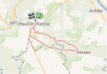
Trail On foot of 5.6 km to be discovered at Wallonia, Namur, Anhée. This trail is proposed by Commissariat général au Tourisme.

Description

Trail created by Vallée de la Meuse Namur-Dinant.


Departure : Place de l'église d'Haut-le-Wastia.

Back to the church, take on the right to go down the street of the Center. After 300m, just before the cemetery, take the path on the left for 250m to join the street of Mossiat that you take on the right for 50m to then take the macadamized road that goes up on the left towards the potale. Follow the path which extends the street and enters the wood. Follow the path called Tienne des Mwarts, so called because it was used as a road to bring the dead from the hamlets to the church of Senenne. At the end of the wood, take the path almost opposite which goes towards a pumping station after 600m. There, you join the macadamized road. You can make a 300m round trip down to the old church of Senenne to do the whole route. Otherwise you go up to the farms of Grange. Just before these, you take a gravel road not macadamized to the right. Join the road near the French Memorial. Take it to the right, ignoring the next one to the right. At the chapel St-Roch, turn right and join the starting point.


Elevation profile

Positioning

Country:
Belgium
Region :
Wallonia
Department/Province :
Namur
Municipality :
Anhée
Location:
Unknown
Start:(UTM)
631228 ; 5574250 (31U) N.

Trails nearby

Trail Walking Anhée - RB-Na-22-raccourci_Vignobles-et-Jardins-d’eau - Photo
Walking
PRO

Walking

Very difficult
(6)
Anhée, Wallonia, Namur, Belgium
16.7 km | 21 km-effort
4h 52min
Yes
Trail Walking Anhée - RB-Na-22_Vignobles-et-Jardins-d’eau - Photo
Walking
PRO

Walking

Very difficult
(11)
Anhée, Wallonia, Namur, Belgium
19.5 km | 25 km-effort
5h 46min
Yes
Trail Walking Yvoir - RB-Na-03 Forteresses, citadelle et abbaye mosanes - Photo
Walking
PRO

Walking

Difficult
(11)
Yvoir, Wallonia, Namur, Belgium
22 km | 30 km-effort
7h 1min
Yes
Trail Walking Yvoir - GG2-Na-38_Godinne-Dinant (2021-11-04) - Photo
Walking
PRO

Walking

Very difficult
(6)
Yvoir, Wallonia, Namur, Belgium
19.5 km | 27 km-effort
6h 13min
No
Trail Walking Anhée - RF-Na-05 Annevoie, côté Jardins_Grande-boucle - Photo
Walking
PRO

Walking

Medium
(11)
Anhée, Wallonia, Namur, Belgium
11.3 km | 14.5 km-effort
3h 6min
Yes
Trail Walking Anhée - RF-Na-05 Annevoie, côté Jardins_Petite-boucle - Photo
Walking
PRO

Walking

Easy
(7)
Anhée, Wallonia, Namur, Belgium
7.4 km | 10 km-effort
2h 7min
Yes
Trail Walking Onhaye - RB-Na-C2-Sommière-Complet_20,4km - Photo
Walking
PRO

Walking

Very difficult
(2)
Onhaye, Wallonia, Namur, Belgium
20 km | 25 km-effort
5h 25min
Yes
Trail Walking Dinant - Balade à Dinant - La Réserve Naturelle de Moniat - Photo
Walking
GUIDE
Desrumaux

Walking

Very easy
(1)
Dinant, Wallonia, Namur, Belgium
8.4 km | 10.9 km-effort
3h 54min
Yes
Trail Walking Anhée - Sosoye - Circuit Natura 2000, des sites qui valent le détour - Na11 - Photo
Walking
GUIDE+

Walking

Medium
(5)
Anhée, Wallonia, Namur, Belgium
4.9 km | 6.3 km-effort
1h 21min
Yes


Close
My subscriptions