![](/images/other/stat-length.png)
![Trail On foot Rendeux - Promenade de Wade les Mollons - Photo](https://media.geolcdn.com/t/1900/400/ext.pjpeg?maxdim=2&url=https%3A%2F%2Fstatic1.geolcdn.com%2Fsiteimages%2Fupload%2Ffiles%2F1545311037marcheuse_200dpi.jpg)
Promenade de Wade les Mollons
Commissariat général au Tourisme
Randonnées du CGT GUIDE+
![Length](/images/other/stat-length.png)
Length
9 km
![Max alt](https://static1.geolcdn.com/siteimages/upload/files/1508320355ic_sort_altitude_max_24dp.png)
Max alt
391 m
![Uphill gradient](https://static1.geolcdn.com/siteimages/upload/files/1508320355ic_sort_den_pos_24dp.png)
Uphill gradient
255 m
![Km-Effort](/images/other/stat-length.png)
Km-Effort
12.4 km
![Min alt](https://static1.geolcdn.com/siteimages/upload/files/1508320355ic_sort_altitude_min_24dp.png)
Min alt
186 m
![Downhill gradient](https://static1.geolcdn.com/siteimages/upload/files/1508320355ic_sort_den_neg_24dp.png)
Downhill gradient
255 m
![Boucle](https://static1.geolcdn.com/siteimages/upload/files/16400158638029165_repeat_loop_refresh_sync_direction_icon.png)
Boucle
Yes
Creation date :
2022-02-08 11:28:10.567
Updated on :
2022-02-21 10:09:07.497
![On foot](https://static1.geolcdn.com/sitytour/trail-icons/100.png)
2h48
Difficulty : Easy
![Scan this QR Code to open this trail in the SityTrail application](https://capi.geolives.com/qq0zvz2zws4bq2lad0pu/sitytour/trails/3080721/qr.png?size=200)
FREE GPS app for hiking
About
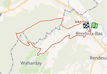
Trail On foot of 9 km to be discovered at Wallonia, Luxembourg, Rendeux. This trail is proposed by Commissariat général au Tourisme.
Description
Trail created by Cœur de l'Ardenne, au fil de l'Ourthe & de l'Aisne.
Positioning
Country:
Belgium
Region :
Wallonia
Department/Province :
Luxembourg
Municipality :
Rendeux
Location:
Unknown
Start:(Dec)
Start:(UTM)
678196 ; 5568613 (31U) N.
Comments
Trails nearby
![Trail Walking Hotton - RF-Lu-03 Sur la Calestienne, entre Ardenne et Famenne : Hotton - Photo](https://media.geolcdn.com/t/375/260/ext.jpg?maxdim=2&url=https%3A%2F%2Fservices.sitytrail.com%2FGeolivesWS%2FDownloadMedia.ashx%3FTrailID%3D407838%26Media%3D5ce28d25-1425-4e98-96ff-2c6c15aabb08.jpg)
![Walking Walking](https://static1.geolcdn.com/sitytour/trail-icons/101.png)
RF-Lu-03 Sur la Calestienne, entre Ardenne et Famenne : Hotton
Walking
Very easy
(3)
Hotton,
Wallonia,
Luxembourg,
Belgium
![](/images/other/stat-length.png)
11.7 km | 15.3 km-effort
3h 16min
![](https://static1.geolcdn.com/siteimages/upload/files/16400158638029165_repeat_loop_refresh_sync_direction_icon.png)
Yes
![Trail Walking Érezée - rando amonines 26/10/2020 - Photo](https://media.geolcdn.com/t/375/260/1ff4a8e3-55b5-4447-9981-776e07faa610.jpg&format=jpg&maxdim=2)
![Walking Walking](https://static1.geolcdn.com/sitytour/trail-icons/101.png)
rando amonines 26/10/2020
Walking
Medium
(1)
Érezée,
Wallonia,
Luxembourg,
Belgium
![](/images/other/stat-length.png)
13.3 km | 18 km-effort
3h 2min
![](https://static1.geolcdn.com/siteimages/upload/files/16400158638029165_repeat_loop_refresh_sync_direction_icon.png)
Yes
![Trail Walking Rendeux - Arboretum et Ourthe - Photo](https://media.geolcdn.com/t/375/260/114fab54-a809-4035-a129-83d982caf499.jpg&format=jpg&maxdim=2)
![Walking Walking](https://static1.geolcdn.com/sitytour/trail-icons/101.png)
Arboretum et Ourthe
Walking
Medium
(4)
Rendeux,
Wallonia,
Luxembourg,
Belgium
![](/images/other/stat-length.png)
9 km | 12 km-effort
3h 15min
![](https://static1.geolcdn.com/siteimages/upload/files/16400158638029165_repeat_loop_refresh_sync_direction_icon.png)
Yes
![Trail Walking Rendeux - hodister - Photo](https://media.geolcdn.com/t/375/260/e73fbed5-6ae2-4bd7-8844-cc4756518ef2.jpg&format=jpg&maxdim=2)
![Walking Walking](https://static1.geolcdn.com/sitytour/trail-icons/101.png)
hodister
Walking
Easy
(1)
Rendeux,
Wallonia,
Luxembourg,
Belgium
![](/images/other/stat-length.png)
8.8 km | 11.5 km-effort
3h 39min
![](https://static1.geolcdn.com/siteimages/upload/files/16400158638029165_repeat_loop_refresh_sync_direction_icon.png)
Yes
![Trail Walking Hotton - Saint-Pierre - Photo](https://media.geolcdn.com/t/375/260/ext.jpg?maxdim=2&url=https%3A%2F%2Fservices.sitytrail.com%2FGeolivesWS%2FDownloadMedia.ashx%3FTrailID%3D204152%26Media%3D4d13859b-e8ea-464e-b6f5-80f7a1b7659d.jpg)
![Walking Walking](https://static1.geolcdn.com/sitytour/trail-icons/101.png)
Saint-Pierre
Walking
Easy
(3)
Hotton,
Wallonia,
Luxembourg,
Belgium
![](/images/other/stat-length.png)
10.9 km | 12.1 km-effort
2h 43min
![](https://static1.geolcdn.com/siteimages/upload/files/16400158638029165_repeat_loop_refresh_sync_direction_icon.png)
Yes
![Trail Walking Rendeux - promenade de lourthe - Photo](https://media.geolcdn.com/t/375/260/ext.jpg?maxdim=2&url=https%3A%2F%2Fservices.sitytrail.com%2FGeolivesWS%2FDownloadMedia.ashx%3FTrailID%3D338833%26Media%3Dfix__20140824184151.jpg)
![Walking Walking](https://static1.geolcdn.com/sitytour/trail-icons/101.png)
promenade de lourthe
Walking
Difficult
(3)
Rendeux,
Wallonia,
Luxembourg,
Belgium
![](/images/other/stat-length.png)
8.1 km | 11 km-effort
2h 35min
![](https://static1.geolcdn.com/siteimages/upload/files/16400158638029165_repeat_loop_refresh_sync_direction_icon.png)
Yes
![Trail Walking Rendeux - Montaigu - Photo](https://media.geolcdn.com/t/375/260/ext.jpg?maxdim=2&url=https%3A%2F%2Fservices.sitytrail.com%2FGeolivesWS%2FDownloadMedia.ashx%3FTrailID%3D264121%26Media%3De6783db9-1bdf-46f4-876d-878e9e4b81fa.jpg)
![Walking Walking](https://static1.geolcdn.com/sitytour/trail-icons/101.png)
![Trail Walking Hotton - De werpin a werpin via Trinal - Photo](https://media.geolcdn.com/t/375/260/ext.jpg?maxdim=2&url=https%3A%2F%2Fservices.sitytrail.com%2FGeolivesWS%2FDownloadMedia.ashx%3FTrailID%3D225931%26Media%3Dfix__20131007161453.jpg)
![Walking Walking](https://static1.geolcdn.com/sitytour/trail-icons/101.png)
De werpin a werpin via Trinal
Walking
Easy
(1)
Hotton,
Wallonia,
Luxembourg,
Belgium
![](/images/other/stat-length.png)
9.3 km | 12.4 km-effort
2h 38min
![](https://static1.geolcdn.com/siteimages/upload/files/16400158638029165_repeat_loop_refresh_sync_direction_icon.png)
Yes