Trail Walking Aleyrac - Aleyrac espuy3 - Photo
 parastat
parastat

User

© OpenStreetMap contributors
Length
Length
11.5 km
Max alt
Max alt
562 m
Uphill gradient
Uphill gradient
345 m
Km-Effort
Km-Effort  
16.1 km
Min alt
Min alt
281 m
Downhill gradient
Downhill gradient
346 m
Boucle
Boucle
Yes
Creation date :
2022-02-06 12:37:06.546
Updated on :
2022-02-06 17:32:15.832

(0 Reviews)

Walking
Walking
3h17
Difficulty : Difficult

Scan this QR Code to open this trail in the SityTrail application

FREE GPS app for hiking

Logo SityTrail SityTrail

IGN / Geographical institutes

Download SityTrail from the App Store Download SityTrail from Google Play

Logo SityTrail SityTrail World

The world is yours!

Download SityTrail from the App Store Download SityTrail from Google Play Download SityTrail on Huawei AppGallery

About

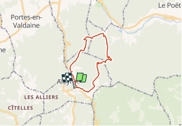
Trail Walking of 11.5 km to be discovered at Auvergne-Rhône-Alpes, Drôme, Aleyrac. This trail is proposed by parastat.

Description

Au km 10,5 continuer sur la piste à droite, elle rejoint le point 11,2km.

Ne pas suivre la trace 10,9km-11,1km-11,2km.
C'est un essai, hors sentier, peu facile, et qui demande de savoir s'orienter.
Cette variante(aleyrac espuy3) permet d'éviter la D9.

Elevation profile

Positioning

Country:
France
Region :
Auvergne-Rhône-Alpes
Department/Province :
Drôme
Municipality :
Aleyrac
Location:
Unknown
Start:(UTM)
654551 ; 4928809 (31T) N.

Trails nearby

Trail Walking Portes-en-Valdaine - GPX-Rando-Plaine-Portoise-nouvelleversion - Photo
Walking
GUIDE
thonyc

Walking

Easy
(1)
Portes-en-Valdaine, Auvergne-Rhône-Alpes, Drôme, France
7.1 km | 8.2 km-effort
2h 0min
Yes
Trail Walking Portes-en-Valdaine - Portes-en-Valdaine Serre-de-Mirabel 11km. - Photo
Walking
chancha

Walking

Difficult
(1)
Portes-en-Valdaine, Auvergne-Rhône-Alpes, Drôme, France
10.8 km | 14.7 km-effort
3h 20min
Yes
Trail Walking La Touche - La Touche Crêtes de l'ysard 12km. - Photo
Walking
chancha

Walking

Difficult
(1)
La Touche, Auvergne-Rhône-Alpes, Drôme, France
12.1 km | 16.8 km-effort
3h 48min
Yes
Trail Walking Portes-en-Valdaine - 26 portes en valdaine - Photo
Walking
GUIDE
randodyssée

Walking

Very easy
Portes-en-Valdaine, Auvergne-Rhône-Alpes, Drôme, France
10.6 km | 14.5 km-effort
4h 10min
Yes
Trail Walking Aleyrac - 26 autour aleyrac - Photo
Walking
GUIDE
randodyssée

Walking

Easy
Aleyrac, Auvergne-Rhône-Alpes, Drôme, France
12.4 km | 15.7 km-effort
4h 50min
No
Trail On foot Portes-en-Valdaine - Rando des 15 en courant #26 - Photo
On foot
Julie LABBE

On foot

Medium
(1)
Portes-en-Valdaine, Auvergne-Rhône-Alpes, Drôme, France
19.4 km | 27 km-effort
6h 9min
Yes
Trail Walking La Touche - La Touche : Les Citelles et Serre Pointu 12km - Photo
Walking
chancha

Walking

Difficult
La Touche, Auvergne-Rhône-Alpes, Drôme, France
12 km | 16.6 km-effort
4h 3min
Yes
Trail Walking La Touche - La Touche Mastaize 9km - Photo
Walking
chancha

Walking

Difficult
La Touche, Auvergne-Rhône-Alpes, Drôme, France
8.6 km | 10.7 km-effort
3h 24min
Yes
Trail Walking Portes-en-Valdaine - 2022-10-01_17h32m32_13243364-1 - Photo
Walking
chancha

Walking

Medium
(1)
Portes-en-Valdaine, Auvergne-Rhône-Alpes, Drôme, France
9.8 km | 13.6 km-effort
3h 2min
Yes


Close
My subscriptions