![](/images/other/stat-length.png)
![Trail Walking La Chapelle-en-Vercors - tour du Vercors en 3 jours - Photo](https://media.geolcdn.com/t/1900/400/ext.pjpeg?maxdim=2&url=https%3A%2F%2Fservices.sitytrail.com%2FGeolivesWS%2FDownloadMedia.ashx%3FTrailID%3D307775%26Media%3Dfix__20140530121133.jpg)
tour du Vercors en 3 jours
fashiondapulse
User
![Length](/images/other/stat-length.png)
Length
60 km
![Max alt](https://static1.geolcdn.com/siteimages/upload/files/1508320355ic_sort_altitude_max_24dp.png)
Max alt
1619 m
![Uphill gradient](https://static1.geolcdn.com/siteimages/upload/files/1508320355ic_sort_den_pos_24dp.png)
Uphill gradient
2121 m
![Km-Effort](/images/other/stat-length.png)
Km-Effort
88 km
![Min alt](https://static1.geolcdn.com/siteimages/upload/files/1508320355ic_sort_altitude_min_24dp.png)
Min alt
825 m
![Downhill gradient](https://static1.geolcdn.com/siteimages/upload/files/1508320355ic_sort_den_neg_24dp.png)
Downhill gradient
2121 m
![Boucle](https://static1.geolcdn.com/siteimages/upload/files/16400158638029165_repeat_loop_refresh_sync_direction_icon.png)
Boucle
Yes
Creation date :
2014-12-10 00:00:00.0
Updated on :
2014-12-10 00:00:00.0
![Walking](https://static1.geolcdn.com/sitytour/trail-icons/101.png)
15h05
Difficulty : Difficult
![Scan this QR Code to open this trail in the SityTrail application](https://capi.geolives.com/qq0zvz2zws4bq2lad0pu/sitytour/trails/307775/qr.png?size=200)
FREE GPS app for hiking
About
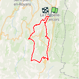
Trail Walking of 60 km to be discovered at Auvergne-Rhône-Alpes, Drôme, La Chapelle-en-Vercors. This trail is proposed by fashiondapulse.
Description
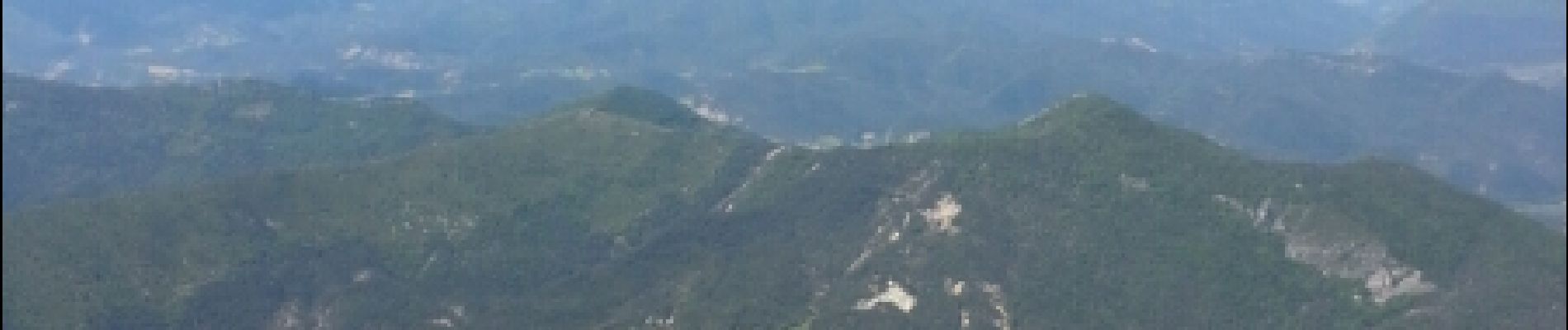
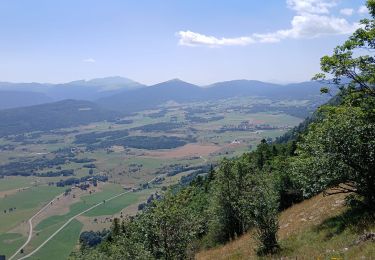
magnifique randonnée de 3 jours. Le deuxième jour est superbe le long des crêtes
2 etapes: le premier soir au col de rousset a l'hôtel carnozet et le deux a font d'urles a l'hôtel le dryades
Positioning
Country:
France
Region :
Auvergne-Rhône-Alpes
Department/Province :
Drôme
Municipality :
La Chapelle-en-Vercors
Location:
Unknown
Start:(Dec)
Start:(UTM)
690540 ; 4982163 (31T) N.
Comments
Trails nearby
![Trail Walking La Chapelle-en-Vercors - Belvedere de la Révoulat - Photo](https://media.geolcdn.com/t/375/260/ext.jpg?maxdim=2&url=https%3A%2F%2Fservices.sitytrail.com%2FGeolivesWS%2FDownloadMedia.ashx%3FTrailID%3D190649%26Media%3Dbea7fca0-eae7-4bcb-a9b2-0754c6f93b9f.JPG)
![Walking Walking](https://static1.geolcdn.com/sitytour/trail-icons/101.png)
Belvedere de la Révoulat
Walking
Easy
(1)
La Chapelle-en-Vercors,
Auvergne-Rhône-Alpes,
Drôme,
France
![](/images/other/stat-length.png)
5.3 km | 10.6 km-effort
2h 5min
![](https://static1.geolcdn.com/siteimages/upload/files/16400158638029165_repeat_loop_refresh_sync_direction_icon.png)
Yes
![Trail Walking Saint-Laurent-en-Royans - 26 rocher des mines ARP - Photo](https://media.geolcdn.com/t/375/260/bd4f581f-b362-467f-a5ca-afa55317a017.jpg&format=jpg&maxdim=2)
![Walking Walking](https://static1.geolcdn.com/sitytour/trail-icons/101.png)
26 rocher des mines ARP
Walking
Very difficult
Saint-Laurent-en-Royans,
Auvergne-Rhône-Alpes,
Drôme,
France
![](/images/other/stat-length.png)
8.6 km | 16.2 km-effort
6h 53min
![](https://static1.geolcdn.com/siteimages/upload/files/16400158638029165_repeat_loop_refresh_sync_direction_icon.png)
Yes
![Trail Walking Saint-Agnan-en-Vercors - 26 tiolache - Photo](https://media.geolcdn.com/t/375/260/901b344f-b319-4266-9f0a-69075395b314.jpg&format=jpg&maxdim=2)
![Walking Walking](https://static1.geolcdn.com/sitytour/trail-icons/101.png)
26 tiolache
Walking
Easy
Saint-Agnan-en-Vercors,
Auvergne-Rhône-Alpes,
Drôme,
France
![](/images/other/stat-length.png)
14.4 km | 21 km-effort
6h 13min
![](https://static1.geolcdn.com/siteimages/upload/files/16400158638029165_repeat_loop_refresh_sync_direction_icon.png)
Yes
![Trail Snowshoes La Chapelle-en-Vercors - 26 raq claveyron - Photo](https://media.geolcdn.com/t/375/260/d59c2ca4-fd91-4928-b5ba-f5a74d483fc8.jpg&format=jpg&maxdim=2)
![Snowshoes Snowshoes](https://static1.geolcdn.com/sitytour/trail-icons/504.png)
26 raq claveyron
Snowshoes
Medium
La Chapelle-en-Vercors,
Auvergne-Rhône-Alpes,
Drôme,
France
![](/images/other/stat-length.png)
15.2 km | 23 km-effort
7h 51min
![](https://static1.geolcdn.com/siteimages/upload/files/16400158638029165_repeat_loop_refresh_sync_direction_icon.png)
Yes
![Trail Walking Saint-Agnan-en-Vercors - 26 st Agnan champ gros de la vache - Photo](https://media.geolcdn.com/t/375/260/3e876886-71b3-45d3-bba1-ada65af3bf18.jpg&format=jpg&maxdim=2)
![Walking Walking](https://static1.geolcdn.com/sitytour/trail-icons/101.png)
26 st Agnan champ gros de la vache
Walking
Medium
Saint-Agnan-en-Vercors,
Auvergne-Rhône-Alpes,
Drôme,
France
![](/images/other/stat-length.png)
16.9 km | 27 km-effort
6h 51min
![](https://static1.geolcdn.com/siteimages/upload/files/16400158638029165_repeat_loop_refresh_sync_direction_icon.png)
Yes
![Trail Walking La Chapelle-en-Vercors - Serre Plumé - Photo](https://media.geolcdn.com/t/375/260/86da3767-95d8-4e79-b2dd-2495b2dc9585.jpg&format=jpg&maxdim=2)
![Walking Walking](https://static1.geolcdn.com/sitytour/trail-icons/101.png)
Serre Plumé
Walking
Medium
La Chapelle-en-Vercors,
Auvergne-Rhône-Alpes,
Drôme,
France
![](/images/other/stat-length.png)
7.2 km | 11.5 km-effort
2h 42min
![](https://static1.geolcdn.com/siteimages/upload/files/16400158638029165_repeat_loop_refresh_sync_direction_icon.png)
Yes
![Trail Walking La Chapelle-en-Vercors - serre plumé depuis carri par la bournette col de la baume grange de vauneyre col de la mure puis les cretes jusqu a pré bellet refuge de crobache lievre blanc scialet royer - Photo](https://media.geolcdn.com/t/375/260/82d39288-8889-4dde-9abf-27f32f728f38.jpg&format=jpg&maxdim=2)
![Walking Walking](https://static1.geolcdn.com/sitytour/trail-icons/101.png)
serre plumé depuis carri par la bournette col de la baume grange de vauneyre ...
Walking
Very difficult
La Chapelle-en-Vercors,
Auvergne-Rhône-Alpes,
Drôme,
France
![](/images/other/stat-length.png)
15.5 km | 25 km-effort
5h 36min
![](https://static1.geolcdn.com/siteimages/upload/files/16400158638029165_repeat_loop_refresh_sync_direction_icon.png)
Yes
![Trail Walking Saint-Martin-en-Vercors - 26 tourtre zels - Photo](https://media.geolcdn.com/t/375/260/98ec91c4-a619-48be-ae84-d1705553fb96.jpg&format=jpg&maxdim=2)
![Walking Walking](https://static1.geolcdn.com/sitytour/trail-icons/101.png)
26 tourtre zels
Walking
Medium
Saint-Martin-en-Vercors,
Auvergne-Rhône-Alpes,
Drôme,
France
![](/images/other/stat-length.png)
14.4 km | 24 km-effort
6h 41min
![](https://static1.geolcdn.com/siteimages/upload/files/16400158638029165_repeat_loop_refresh_sync_direction_icon.png)
No
![Trail Snowshoes Bouvante - 26 serre plume - Photo](https://media.geolcdn.com/t/375/260/7eb6437e-563a-4eca-8375-6c37b57249f0.jpg&format=jpg&maxdim=2)
![Snowshoes Snowshoes](https://static1.geolcdn.com/sitytour/trail-icons/504.png)
26 serre plume
Snowshoes
Medium
Bouvante,
Auvergne-Rhône-Alpes,
Drôme,
France
![](/images/other/stat-length.png)
12.4 km | 20 km-effort
6h 23min
![](https://static1.geolcdn.com/siteimages/upload/files/16400158638029165_repeat_loop_refresh_sync_direction_icon.png)
Yes