![](/images/other/stat-length.png)
![Trail Walking Crots - pic de morgon (boucle) - Photo](https://media.geolcdn.com/t/1900/400/ext.pjpeg?maxdim=2&url=https%3A%2F%2Fstatic1.geolcdn.com%2Fsiteimages%2Fupload%2Ffiles%2F1553511878bg_sport_marche.png)
pic de morgon (boucle)
Equedreu
User
![Length](/images/other/stat-length.png)
![Max alt](https://static1.geolcdn.com/siteimages/upload/files/1508320355ic_sort_altitude_max_24dp.png)
![Uphill gradient](https://static1.geolcdn.com/siteimages/upload/files/1508320355ic_sort_den_pos_24dp.png)
![Km-Effort](/images/other/stat-length.png)
![Min alt](https://static1.geolcdn.com/siteimages/upload/files/1508320355ic_sort_altitude_min_24dp.png)
![Downhill gradient](https://static1.geolcdn.com/siteimages/upload/files/1508320355ic_sort_den_neg_24dp.png)
![Boucle](https://static1.geolcdn.com/siteimages/upload/files/16400158638029165_repeat_loop_refresh_sync_direction_icon.png)
![Walking](https://static1.geolcdn.com/sitytour/trail-icons/101.png)
6h00
Difficulty : Difficult
![Scan this QR Code to open this trail in the SityTrail application](https://capi.geolives.com/qq0zvz2zws4bq2lad0pu/sitytour/trails/307753/qr.png?size=200)
FREE GPS app for hiking
About
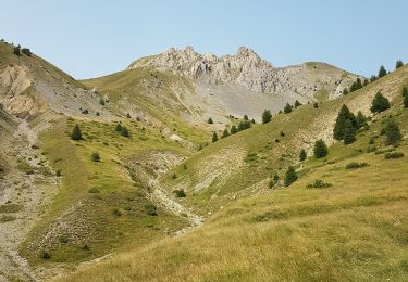
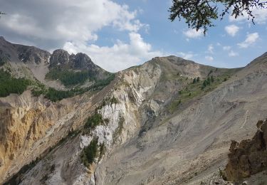
Trail Walking of 18.3 km to be discovered at Provence-Alpes-Côte d'Azur, Hautes-Alpes, Crots. This trail is proposed by Equedreu.
Description
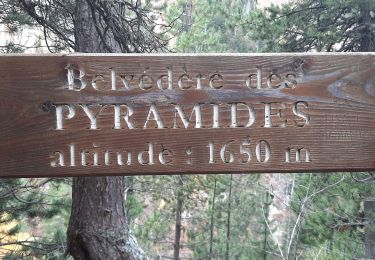
Randonnée en boucle au départ du parking de la Fontaine aux Ours jusqu'au col de la Baisse par le sentier de Charance. Puis on rejoint la crête qui nous amène au sommet (attention, 2 petits passage aériens) puis redescente par le sentier 'normal' jusqu'au parking du grand clot et on rejoint le point de départ par le sentier des pyramides.
Positioning
Comments
Trails nearby
![Trail Walking Crots - Le Cirque de Morgon - Photo](https://media.geolcdn.com/t/375/260/ext.jpg?maxdim=2&url=https%3A%2F%2Fservices.sitytrail.com%2FGeolivesWS%2FDownloadMedia.ashx%3FTrailID%3D109626%26Media%3D4261_1.jpg)
![Walking Walking](https://static1.geolcdn.com/sitytour/trail-icons/101.png)
Walking
![](/images/other/stat-length.png)
![](https://static1.geolcdn.com/siteimages/upload/files/16400158638029165_repeat_loop_refresh_sync_direction_icon.png)
![Trail Walking Crots - Morgon par le Grand Clot - Photo](https://media.geolcdn.com/t/375/260/2470b249-9732-40d6-87a8-fc728b4285cc.jpg&format=jpg&maxdim=2)
![Walking Walking](https://static1.geolcdn.com/sitytour/trail-icons/101.png)
Walking
![](/images/other/stat-length.png)
![](https://static1.geolcdn.com/siteimages/upload/files/16400158638029165_repeat_loop_refresh_sync_direction_icon.png)
![Trail Walking Le Lauzet-Ubaye - Trou du Duc - Photo](https://media.geolcdn.com/t/375/260/8d22ddf9-b4a5-4c35-afa0-70c092e068d5.jpg&format=jpg&maxdim=2)
![Walking Walking](https://static1.geolcdn.com/sitytour/trail-icons/101.png)
Walking
![](/images/other/stat-length.png)
![](https://static1.geolcdn.com/siteimages/upload/files/16400158638029165_repeat_loop_refresh_sync_direction_icon.png)
![Trail Walking Le Lauzet-Ubaye - Trou du Duc - Photo](https://media.geolcdn.com/t/375/260/fac38773-4029-4697-b282-35c17c889efd.jpg&format=jpg&maxdim=2)
![Walking Walking](https://static1.geolcdn.com/sitytour/trail-icons/101.png)
Walking
![](/images/other/stat-length.png)
![](https://static1.geolcdn.com/siteimages/upload/files/16400158638029165_repeat_loop_refresh_sync_direction_icon.png)
![Trail Walking Crots - Grand Morgon - Photo](https://media.geolcdn.com/t/375/260/c2ea8bef-d143-4c62-a26e-6fbe8e0329c8.jpg&format=jpg&maxdim=2)
![Walking Walking](https://static1.geolcdn.com/sitytour/trail-icons/101.png)
Walking
![](/images/other/stat-length.png)
![](https://static1.geolcdn.com/siteimages/upload/files/16400158638029165_repeat_loop_refresh_sync_direction_icon.png)
![Trail Walking Crots - SityTrail - 2251353 - morgon-par-le-grand-clot - Photo](https://media.geolcdn.com/t/375/260/1bb998f8-1a6a-4350-bb2c-9f136211e7d5.jpg&format=jpg&maxdim=2)
![Walking Walking](https://static1.geolcdn.com/sitytour/trail-icons/101.png)
Walking
![](/images/other/stat-length.png)
![](https://static1.geolcdn.com/siteimages/upload/files/16400158638029165_repeat_loop_refresh_sync_direction_icon.png)
![Trail Walking Crots - Morgon par la fontaine de l'Ours - Photo](https://media.geolcdn.com/t/375/260/e020d87b-3349-4509-bff9-6b59601d138c.jpg&format=jpg&maxdim=2)
![Walking Walking](https://static1.geolcdn.com/sitytour/trail-icons/101.png)
Walking
![](/images/other/stat-length.png)
![](https://static1.geolcdn.com/siteimages/upload/files/16400158638029165_repeat_loop_refresh_sync_direction_icon.png)
![Trail Walking Crots - LES CROTS Boscodon ,Fontaine de l Ours ,sentier des Pyramides cirque du Morgon o m - Photo](https://media.geolcdn.com/t/375/260/94dbf83e-b1dc-42f7-b3af-31980f7aee36.jpg&format=jpg&maxdim=2)
![Walking Walking](https://static1.geolcdn.com/sitytour/trail-icons/101.png)
Walking
![](/images/other/stat-length.png)
![](https://static1.geolcdn.com/siteimages/upload/files/16400158638029165_repeat_loop_refresh_sync_direction_icon.png)
![Trail Mountain bike Savines-le-Lac - circuit de serre verger N°25 - Photo](https://media.geolcdn.com/t/375/260/ext.jpg?maxdim=2&url=https%3A%2F%2Fstatic1.geolcdn.com%2Fsiteimages%2Fupload%2Ffiles%2F1524743154velo.jpg)
![Mountain bike Mountain bike](https://static1.geolcdn.com/sitytour/trail-icons/202.png)
Mountain bike
![](/images/other/stat-length.png)
![](https://static1.geolcdn.com/siteimages/upload/files/16400158638029165_repeat_loop_refresh_sync_direction_icon.png)