Trail Walking Perrigny-sur-Loire - Perrigny sur Loire par Fontête-Vellerot et retour - Photo

Perrigny sur Loire par Fontête-Vellerot et retour

© OpenStreetMap contributors
Length
Length
10.7 km
Max alt
Max alt
308 m
Uphill gradient
Uphill gradient
208 m
Km-Effort
Km-Effort  
13.5 km
Min alt
Min alt
233 m
Downhill gradient
Downhill gradient
204 m
Boucle
Boucle
Yes
Creation date :
2022-02-05 09:34:47.454
Updated on :
2022-02-05 09:49:36.461

(0 Reviews)

Walking
Walking
3h03
Difficulty : Difficult

Scan this QR Code to open this trail in the SityTrail application

FREE GPS app for hiking

Logo SityTrail SityTrail

IGN / Geographical institutes

Download SityTrail from the App Store Download SityTrail from Google Play

Logo SityTrail SityTrail World

The world is yours!

Download SityTrail from the App Store Download SityTrail from Google Play Download SityTrail on Huawei AppGallery

About

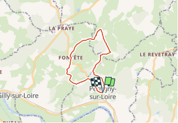
Trail Walking of 10.7 km to be discovered at Bourgogne-Franche-Comté, Saône-et-Loire, Perrigny-sur-Loire. This trail is proposed by Praticrando.

Description

Départ Eglise de Perrigny, prendre la D192 en direction de Chalmoux, Bourbon. Suivre la route jusqu'au chemin des Bruyères, prendre le chemin et continuer. Vue sur les prairies . Rester sur le chemin carrosable, ne pas aller vers le chateau d'eau. Ca descend et on rattrape une route communale. Prendre à droite vers Fontête. Au carrefour prendre la route en face et 300 m plus loin à droite la route qui monte entre les maisons du lieu dit. Et encore à droite. Poursuivre en direction du Moulin Puzenat, passer le ruisseau (le Doulin) et aller jusqu'au Vellerot. Contourner sur la route et prendre direction le Praillon. Vous quitter le bitume.  Continuer sur le chemin de terre et au premier carrefour à droite. Remonter vers la route communale. En arrivant sur la route prendre à votre gauche et suivre la route  qui passe dans les bois jusqu'à Perrigny.

Elevation profile

Positioning

Country:
France
Region :
Bourgogne-Franche-Comté
Department/Province :
Saône-et-Loire
Municipality :
Perrigny-sur-Loire
Location:
Unknown
Start:(UTM)
564292 ; 5154258 (31T) N.

Trails nearby

Trail Mountain bike Pierrefitte-sur-Loire - canal Loire - Photo
Mountain bike
jipelaire

Mountain bike

Very difficult
Pierrefitte-sur-Loire, Auvergne-Rhône-Alpes, Allier, France
53 km | 57 km-effort
3h 37min
No
Trail Walking Pierrefitte-sur-Loire - pierrefitte sur Loire - Photo
Walking
kronio

Walking

Very easy
Pierrefitte-sur-Loire, Auvergne-Rhône-Alpes, Allier, France
10.2 km | 10.9 km-effort
2h 26min
Yes
Trail Walking Perrigny-sur-Loire - Perrigny sans nom - Photo
Walking
Praticrando

Walking

Medium
Perrigny-sur-Loire, Bourgogne-Franche-Comté, Saône-et-Loire, France
7.1 km | 9 km-effort
2h 2min
Yes
Trail Walking Chalmoux - autour de bourbon lancy: la grande ouche - Photo
Walking
jojoh2o

Walking

Easy
Chalmoux, Bourgogne-Franche-Comté, Saône-et-Loire, France
4 km | 4.9 km-effort
59min
Yes


Close
My subscriptions