![](/images/other/stat-length.png)
![Trail Walking Sceautres - tour du coiron - Photo](https://media.geolcdn.com/t/1900/400/ext.pjpeg?maxdim=2&url=https%3A%2F%2Fstatic1.geolcdn.com%2Fsiteimages%2Fupload%2Ffiles%2F1553511878bg_sport_marche.png)
tour du coiron
royco
User
![Length](/images/other/stat-length.png)
Length
6.7 km
![Max alt](https://static1.geolcdn.com/siteimages/upload/files/1508320355ic_sort_altitude_max_24dp.png)
Max alt
688 m
![Uphill gradient](https://static1.geolcdn.com/siteimages/upload/files/1508320355ic_sort_den_pos_24dp.png)
Uphill gradient
229 m
![Km-Effort](/images/other/stat-length.png)
Km-Effort
9.8 km
![Min alt](https://static1.geolcdn.com/siteimages/upload/files/1508320355ic_sort_altitude_min_24dp.png)
Min alt
480 m
![Downhill gradient](https://static1.geolcdn.com/siteimages/upload/files/1508320355ic_sort_den_neg_24dp.png)
Downhill gradient
238 m
![Boucle](https://static1.geolcdn.com/siteimages/upload/files/16400158638029165_repeat_loop_refresh_sync_direction_icon.png)
Boucle
Yes
Creation date :
2014-12-10 00:00:00.0
Updated on :
2014-12-10 00:00:00.0
![Walking](https://static1.geolcdn.com/sitytour/trail-icons/101.png)
2h14
Difficulty : Medium
![Scan this QR Code to open this trail in the SityTrail application](https://capi.geolives.com/qq0zvz2zws4bq2lad0pu/sitytour/trails/307624/qr.png?size=200)
FREE GPS app for hiking
About
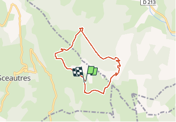
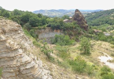
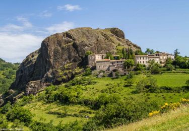
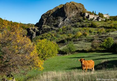
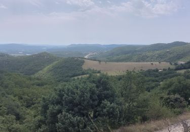
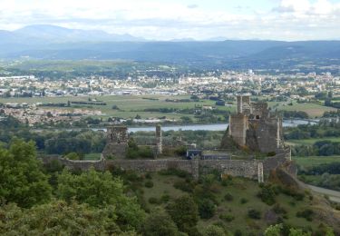
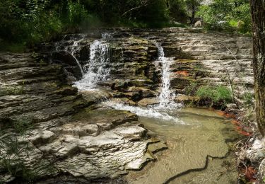
Trail Walking of 6.7 km to be discovered at Auvergne-Rhône-Alpes, Ardèche, Sceautres. This trail is proposed by royco.
Description
permet aux promeneurs de découvrir un chemin en descente depuis LA BORIE ainsi qu'un magnifique chemin en montée vers le BOIS DE VAl a faire dans le sens horaire.
Positioning
Country:
France
Region :
Auvergne-Rhône-Alpes
Department/Province :
Ardèche
Municipality :
Sceautres
Location:
Unknown
Start:(Dec)
Start:(UTM)
629601 ; 4941390 (31T) N.
Comments
Trails nearby
![Trail Walking Saint-Pons - St-Pons](https://media.geolcdn.com/t/375/260/49091a69-1e24-42da-a42c-558f715b7cf2.jpg&format=jpg&maxdim=2)
![Walking Walking](https://static1.geolcdn.com/sitytour/trail-icons/101.png)
St-Pons" Roche-Cherie" 11km.
Walking
Difficult
(1)
Saint-Pons,
Auvergne-Rhône-Alpes,
Ardèche,
France
![](/images/other/stat-length.png)
10.5 km | 15.5 km-effort
3h 31min
![](https://static1.geolcdn.com/siteimages/upload/files/16400158638029165_repeat_loop_refresh_sync_direction_icon.png)
Yes
![Trail Walking Alba-la-Romaine - Alba côté Coiron 7km - Photo](https://media.geolcdn.com/t/375/260/a3628db1-82f7-410a-bbb5-05b986f870eb.jpg&format=jpg&maxdim=2)
![Walking Walking](https://static1.geolcdn.com/sitytour/trail-icons/101.png)
Alba côté Coiron 7km
Walking
Easy
(1)
Alba-la-Romaine,
Auvergne-Rhône-Alpes,
Ardèche,
France
![](/images/other/stat-length.png)
7.1 km | 9.5 km-effort
2h 30min
![](https://static1.geolcdn.com/siteimages/upload/files/16400158638029165_repeat_loop_refresh_sync_direction_icon.png)
Yes
![Trail Walking Rochemaure - Randonnée entre Rochemaure et Aubignas - Photo](https://media.geolcdn.com/t/375/260/ext.jpg?maxdim=2&url=https%3A%2F%2Fservices.sitytrail.com%2FGeolivesWS%2FDownloadMedia.ashx%3FTrailID%3D104553%26Media%3D7931_3.jpg)
![Walking Walking](https://static1.geolcdn.com/sitytour/trail-icons/101.png)
Randonnée entre Rochemaure et Aubignas
Walking
Difficult
(2)
Rochemaure,
Auvergne-Rhône-Alpes,
Ardèche,
France
![](/images/other/stat-length.png)
16.8 km | 26 km-effort
5h 30min
![](https://static1.geolcdn.com/siteimages/upload/files/16400158638029165_repeat_loop_refresh_sync_direction_icon.png)
Yes
![Trail Walking Alba-la-Romaine - 2022-03-12_17h47m49_Sceautres-La carrière 15km.gpx.xml - Photo](https://media.geolcdn.com/t/375/260/bc490022-33bf-4369-aab3-d65614438b0b.jpg&format=jpg&maxdim=2)
![Walking Walking](https://static1.geolcdn.com/sitytour/trail-icons/101.png)
2022-03-12_17h47m49_Sceautres-La carrière 15km.gpx.xml
Walking
Very difficult
(1)
Alba-la-Romaine,
Auvergne-Rhône-Alpes,
Ardèche,
France
![](/images/other/stat-length.png)
14.7 km | 22 km-effort
4h 57min
![](https://static1.geolcdn.com/siteimages/upload/files/16400158638029165_repeat_loop_refresh_sync_direction_icon.png)
Yes
![Trail Walking Rochemaure - Le Chenavary 11km. - Photo](https://media.geolcdn.com/t/375/260/dfb34e99-cb97-4de8-a99a-52eb6b293bd1.jpg&format=jpg&maxdim=2)
![Walking Walking](https://static1.geolcdn.com/sitytour/trail-icons/101.png)
Le Chenavary 11km.
Walking
Difficult
Rochemaure,
Auvergne-Rhône-Alpes,
Ardèche,
France
![](/images/other/stat-length.png)
11 km | 17.3 km-effort
3h 56min
![](https://static1.geolcdn.com/siteimages/upload/files/16400158638029165_repeat_loop_refresh_sync_direction_icon.png)
Yes
![Trail Walking Aubignas - Aubignas Chenavari 17km - Photo](https://media.geolcdn.com/t/375/260/68a339cd-0c18-4833-bd47-74ba80f6463a.jpeg&format=jpg&maxdim=2)
![Walking Walking](https://static1.geolcdn.com/sitytour/trail-icons/101.png)
Aubignas Chenavari 17km
Walking
Difficult
Aubignas,
Auvergne-Rhône-Alpes,
Ardèche,
France
![](/images/other/stat-length.png)
16.5 km | 25 km-effort
5h 20min
![](https://static1.geolcdn.com/siteimages/upload/files/16400158638029165_repeat_loop_refresh_sync_direction_icon.png)
Yes
![Trail Mountain bike Aubignas - Aubignas tour coiron all mountain - Photo](https://media.geolcdn.com/t/375/260/ext.jpg?maxdim=2&url=https%3A%2F%2Fstatic1.geolcdn.com%2Fsiteimages%2Fupload%2Ffiles%2F1524743154velo.jpg)
![Mountain bike Mountain bike](https://static1.geolcdn.com/sitytour/trail-icons/202.png)
Aubignas tour coiron all mountain
Mountain bike
Difficult
(2)
Aubignas,
Auvergne-Rhône-Alpes,
Ardèche,
France
![](/images/other/stat-length.png)
20 km | 30 km-effort
1h 54min
![](https://static1.geolcdn.com/siteimages/upload/files/16400158638029165_repeat_loop_refresh_sync_direction_icon.png)
No
![Trail Mountain bike Sceautres - COIRON boucle sympa - Photo](https://media.geolcdn.com/t/375/260/ext.jpg?maxdim=2&url=https%3A%2F%2Fstatic1.geolcdn.com%2Fsiteimages%2Fupload%2Ffiles%2F1524743154velo.jpg)
![Mountain bike Mountain bike](https://static1.geolcdn.com/sitytour/trail-icons/202.png)
COIRON boucle sympa
Mountain bike
Medium
(2)
Sceautres,
Auvergne-Rhône-Alpes,
Ardèche,
France
![](/images/other/stat-length.png)
7.4 km | 10.4 km-effort
1h 10min
![](https://static1.geolcdn.com/siteimages/upload/files/16400158638029165_repeat_loop_refresh_sync_direction_icon.png)
Yes
![Trail Walking Saint-Martin-sur-Lavezon - 2024-02-01_17h36m53_St Martin sur Lavezon - Photo](https://media.geolcdn.com/t/375/260/fae9a361-89ad-48b5-aac3-71b02cd783dd.jpg&format=jpg&maxdim=2)
![Walking Walking](https://static1.geolcdn.com/sitytour/trail-icons/101.png)
2024-02-01_17h36m53_St Martin sur Lavezon
Walking
Very difficult
Saint-Martin-sur-Lavezon,
Auvergne-Rhône-Alpes,
Ardèche,
France
![](/images/other/stat-length.png)
16 km | 24 km-effort
5h 26min
![](https://static1.geolcdn.com/siteimages/upload/files/16400158638029165_repeat_loop_refresh_sync_direction_icon.png)
Yes