![](/images/other/stat-length.png)
![Trail Snowshoes Vars - Les Claux - Napoléon - cabane du vallon - Peynier AR - Photo](https://media.geolcdn.com/t/1900/400/ext.pjpeg?maxdim=2&url=https%3A%2F%2Fstatic1.geolcdn.com%2Fsiteimages%2Fupload%2Ffiles%2F1524743153raquette.jpg)
Les Claux - Napoléon - cabane du vallon - Peynier AR
jl77130
User
![Length](/images/other/stat-length.png)
Length
15.7 km
![Max alt](https://static1.geolcdn.com/siteimages/upload/files/1508320355ic_sort_altitude_max_24dp.png)
Max alt
2303 m
![Uphill gradient](https://static1.geolcdn.com/siteimages/upload/files/1508320355ic_sort_den_pos_24dp.png)
Uphill gradient
598 m
![Km-Effort](/images/other/stat-length.png)
Km-Effort
24 km
![Min alt](https://static1.geolcdn.com/siteimages/upload/files/1508320355ic_sort_altitude_min_24dp.png)
Min alt
1892 m
![Downhill gradient](https://static1.geolcdn.com/siteimages/upload/files/1508320355ic_sort_den_neg_24dp.png)
Downhill gradient
599 m
![Boucle](https://static1.geolcdn.com/siteimages/upload/files/16400158638029165_repeat_loop_refresh_sync_direction_icon.png)
Boucle
Yes
Creation date :
2022-02-04 09:02:52.0
Updated on :
2022-02-04 16:04:43.475
![Snowshoes](https://static1.geolcdn.com/sitytour/trail-icons/504.png)
7h00
Difficulty : Medium
![Scan this QR Code to open this trail in the SityTrail application](https://capi.geolives.com/qq0zvz2zws4bq2lad0pu/sitytour/trails/3075801/qr.png?size=200)
FREE GPS app for hiking
About
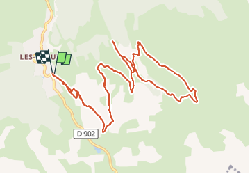
Trail Snowshoes of 15.7 km to be discovered at Provence-Alpes-Côte d'Azur, Hautes-Alpes, Vars. This trail is proposed by jl77130.
Description
Rando en raquettes pour la portion partant de la retenue d’eau sous Peynier jusqu’à la cabane du vallon. Tout le reste en crampons sur chaussures de randonnée.
Positioning
Country:
France
Region :
Provence-Alpes-Côte d'Azur
Department/Province :
Hautes-Alpes
Municipality :
Vars
Location:
Unknown
Start:(Dec)
Start:(UTM)
316190 ; 4937745 (32T) N.
Comments
Trails nearby
![Trail Walking Crévoux - La Cascade de Razis - Photo](https://media.geolcdn.com/t/375/260/ext.jpg?maxdim=2&url=https%3A%2F%2Fservices.sitytrail.com%2FGeolivesWS%2FDownloadMedia.ashx%3FTrailID%3D109634%26Media%3D4275_1.jpg)
![Walking Walking](https://static1.geolcdn.com/sitytour/trail-icons/101.png)
La Cascade de Razis
Walking
Medium
(5)
Crévoux,
Provence-Alpes-Côte d'Azur,
Hautes-Alpes,
France
![](/images/other/stat-length.png)
7.2 km | 11 km-effort
3h 30min
![](https://static1.geolcdn.com/siteimages/upload/files/16400158638029165_repeat_loop_refresh_sync_direction_icon.png)
Yes
![Trail Walking Crévoux - boucle lac du crachet - Photo](https://media.geolcdn.com/t/375/260/ext.jpg?maxdim=2&url=https%3A%2F%2Fservices.sitytrail.com%2FGeolivesWS%2FDownloadMedia.ashx%3FTrailID%3D619371%26Media%3Dfix__20160821105233.jpg)
![Walking Walking](https://static1.geolcdn.com/sitytour/trail-icons/101.png)
boucle lac du crachet
Walking
Difficult
(1)
Crévoux,
Provence-Alpes-Côte d'Azur,
Hautes-Alpes,
France
![](/images/other/stat-length.png)
10.3 km | 21 km-effort
4h 50min
![](https://static1.geolcdn.com/siteimages/upload/files/16400158638029165_repeat_loop_refresh_sync_direction_icon.png)
Yes
![Trail Walking Crévoux - PARCOURS DES FEES #7 - Photo](https://media.geolcdn.com/t/375/260/ext.jpg?maxdim=2&url=https%3A%2F%2Fservices.sitytrail.com%2FGeolivesWS%2FDownloadMedia.ashx%3FTrailID%3D606320%26Media%3D812d22bb-a879-4b52-81d0-d1a210f7c536.JPG)
![Walking Walking](https://static1.geolcdn.com/sitytour/trail-icons/101.png)
PARCOURS DES FEES #7
Walking
Medium
(1)
Crévoux,
Provence-Alpes-Côte d'Azur,
Hautes-Alpes,
France
![](/images/other/stat-length.png)
8.3 km | 11.6 km-effort
2h 35min
![](https://static1.geolcdn.com/siteimages/upload/files/16400158638029165_repeat_loop_refresh_sync_direction_icon.png)
Yes
![Trail Walking Vars - boucle col de Vars - Photo](https://media.geolcdn.com/t/375/260/ext.jpg?maxdim=2&url=https%3A%2F%2Fservices.sitytrail.com%2FGeolivesWS%2FDownloadMedia.ashx%3FTrailID%3D445272%26Media%3Dfix__20150714142947.jpg)
![Walking Walking](https://static1.geolcdn.com/sitytour/trail-icons/101.png)
boucle col de Vars
Walking
Easy
(2)
Vars,
Provence-Alpes-Côte d'Azur,
Hautes-Alpes,
France
![](/images/other/stat-length.png)
4.5 km | 6.1 km-effort
2h 39min
![](https://static1.geolcdn.com/siteimages/upload/files/16400158638029165_repeat_loop_refresh_sync_direction_icon.png)
Yes
![Trail Walking Vars - Crêtes de Vars - Photo](https://media.geolcdn.com/t/375/260/ext.jpg?maxdim=2&url=https%3A%2F%2Fservices.sitytrail.com%2FGeolivesWS%2FDownloadMedia.ashx%3FTrailID%3D197621%26Media%3D20130611134031.jpeg)
![Walking Walking](https://static1.geolcdn.com/sitytour/trail-icons/101.png)
Crêtes de Vars
Walking
Medium
(2)
Vars,
Provence-Alpes-Côte d'Azur,
Hautes-Alpes,
France
![](/images/other/stat-length.png)
7.7 km | 14.9 km-effort
4h 0min
![](https://static1.geolcdn.com/siteimages/upload/files/16400158638029165_repeat_loop_refresh_sync_direction_icon.png)
Yes
![Trail Walking Vars - Tête de Paneyron - Col de Vars - Photo](https://media.geolcdn.com/t/375/260/ext.jpg?maxdim=2&url=https%3A%2F%2Fservices.sitytrail.com%2FGeolivesWS%2FDownloadMedia.ashx%3FTrailID%3D172673%26Media%3D14054_1.jpg)
![Walking Walking](https://static1.geolcdn.com/sitytour/trail-icons/101.png)
Tête de Paneyron - Col de Vars
Walking
Difficult
(1)
Vars,
Provence-Alpes-Côte d'Azur,
Hautes-Alpes,
France
![](/images/other/stat-length.png)
10 km | 19 km-effort
3h 0min
![](https://static1.geolcdn.com/siteimages/upload/files/16400158638029165_repeat_loop_refresh_sync_direction_icon.png)
Yes
![Trail Walking Saint-Paul-sur-Ubaye - pointe de l'Eyssina - Photo](https://media.geolcdn.com/t/375/260/f4ffe486-ca5f-4a55-a510-6c4db13d053f.jpg&format=jpg&maxdim=2)
![Walking Walking](https://static1.geolcdn.com/sitytour/trail-icons/101.png)
pointe de l'Eyssina
Walking
Medium
Saint-Paul-sur-Ubaye,
Provence-Alpes-Côte d'Azur,
Alpes-de-Haute-Provence,
France
![](/images/other/stat-length.png)
8.7 km | 18 km-effort
6h 54min
![](https://static1.geolcdn.com/siteimages/upload/files/16400158638029165_repeat_loop_refresh_sync_direction_icon.png)
No
![Trail Walking Vars - Pic de Chabrières 2744m 31.7.22 - Photo](https://media.geolcdn.com/t/375/260/27b448de-709d-4eac-ac4d-b3bdd6c8e895.jpg&format=jpg&maxdim=2)
![Walking Walking](https://static1.geolcdn.com/sitytour/trail-icons/101.png)
Pic de Chabrières 2744m 31.7.22
Walking
Difficult
Vars,
Provence-Alpes-Côte d'Azur,
Hautes-Alpes,
France
![](/images/other/stat-length.png)
9.7 km | 15.9 km-effort
3h 25min
![](https://static1.geolcdn.com/siteimages/upload/files/16400158638029165_repeat_loop_refresh_sync_direction_icon.png)
No
![Trail Walking Crévoux - Sentier des Fées Crevoux 16/08/18 - Photo](https://media.geolcdn.com/t/375/260/62d5f5b8-1ebc-4b09-a28c-b9abebde2749.jpg&format=jpg&maxdim=2)
![Walking Walking](https://static1.geolcdn.com/sitytour/trail-icons/101.png)
Sentier des Fées Crevoux 16/08/18
Walking
Easy
Crévoux,
Provence-Alpes-Côte d'Azur,
Hautes-Alpes,
France
![](/images/other/stat-length.png)
6.1 km | 9 km-effort
1h 52min
![](https://static1.geolcdn.com/siteimages/upload/files/16400158638029165_repeat_loop_refresh_sync_direction_icon.png)
Yes