![](/images/other/stat-length.png)
![Trail Walking Aucelon - Col de Pennes - Photo](https://media.geolcdn.com/t/1900/400/e2c39de6-5320-415f-8eb7-c526a1164e2d.jpg&format=pjpeg&maxdim=2)
Col de Pennes
ajd26
User
![Length](/images/other/stat-length.png)
Length
14.2 km
![Max alt](https://static1.geolcdn.com/siteimages/upload/files/1508320355ic_sort_altitude_max_24dp.png)
Max alt
1322 m
![Uphill gradient](https://static1.geolcdn.com/siteimages/upload/files/1508320355ic_sort_den_pos_24dp.png)
Uphill gradient
706 m
![Km-Effort](/images/other/stat-length.png)
Km-Effort
24 km
![Min alt](https://static1.geolcdn.com/siteimages/upload/files/1508320355ic_sort_altitude_min_24dp.png)
Min alt
853 m
![Downhill gradient](https://static1.geolcdn.com/siteimages/upload/files/1508320355ic_sort_den_neg_24dp.png)
Downhill gradient
709 m
![Boucle](https://static1.geolcdn.com/siteimages/upload/files/16400158638029165_repeat_loop_refresh_sync_direction_icon.png)
Boucle
Yes
Creation date :
2022-02-03 08:13:12.0
Updated on :
2022-02-04 09:45:06.433
![Walking](https://static1.geolcdn.com/sitytour/trail-icons/101.png)
4h46
Difficulty : Medium
![Scan this QR Code to open this trail in the SityTrail application](https://capi.geolives.com/qq0zvz2zws4bq2lad0pu/sitytour/trails/3074928/qr.png?size=200)
FREE GPS app for hiking
About
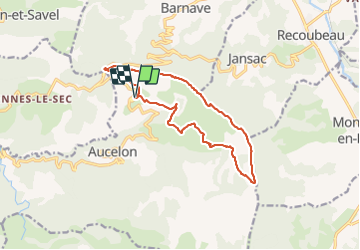
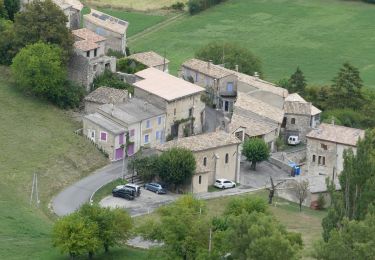
Trail Walking of 14.2 km to be discovered at Auvergne-Rhône-Alpes, Drôme, Aucelon. This trail is proposed by ajd26.
Description
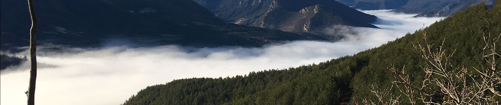
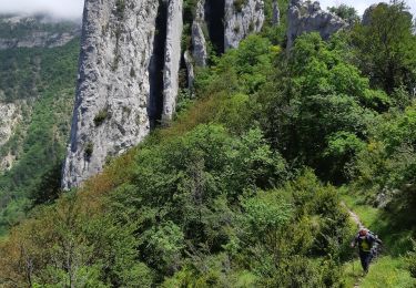
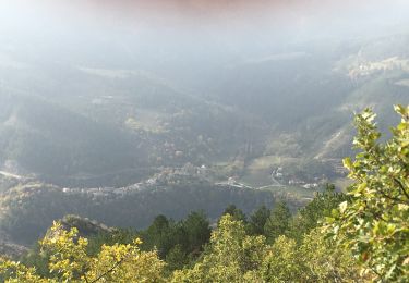
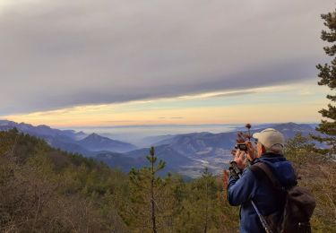
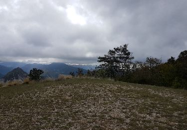
depuis le Deves, montée au col de Pennes et déambulation sur les crêtes (6km) avec de superbes panoramas sur la vallée de la Drome et le Dévoluy magnifique
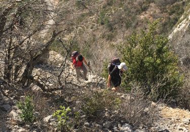
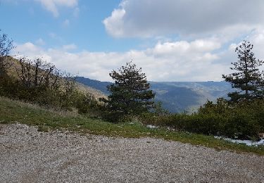
sur le retour, au km 12, possibilité de continuer par la piste car le petit sentier est un peu hasardeux sur la fin
Positioning
Country:
France
Region :
Auvergne-Rhône-Alpes
Department/Province :
Drôme
Municipality :
Aucelon
Location:
Unknown
Start:(Dec)
Start:(UTM)
686638 ; 4945396 (31T) N.
Comments
Trails nearby
![Trail Walking Rimon-et-Savel - 26 lames de pennes savel jp - Photo](https://media.geolcdn.com/t/375/260/f2bea45a-9c65-4d39-b93d-6507c3374444.jpg&format=jpg&maxdim=2)
![Walking Walking](https://static1.geolcdn.com/sitytour/trail-icons/101.png)
26 lames de pennes savel jp
Walking
Medium
Rimon-et-Savel,
Auvergne-Rhône-Alpes,
Drôme,
France
![](/images/other/stat-length.png)
10.8 km | 0 m-effort
7h 56min
![](https://static1.geolcdn.com/siteimages/upload/files/16400158638029165_repeat_loop_refresh_sync_direction_icon.png)
Yes
![Trail Walking Rimon-et-Savel - balcons de la Roanne - Photo](https://media.geolcdn.com/t/375/260/6f529a2b-52ed-4864-b6b1-e2b0e3236399.jpg&format=jpg&maxdim=2)
![Walking Walking](https://static1.geolcdn.com/sitytour/trail-icons/101.png)
balcons de la Roanne
Walking
Medium
Rimon-et-Savel,
Auvergne-Rhône-Alpes,
Drôme,
France
![](/images/other/stat-length.png)
18.8 km | 29 km-effort
5h 17min
![](https://static1.geolcdn.com/siteimages/upload/files/16400158638029165_repeat_loop_refresh_sync_direction_icon.png)
Yes
![Trail Walking Rimon-et-Savel - rimon 2/1/2022 - Photo](https://media.geolcdn.com/t/375/260/d71302a3-bf5b-468d-ad27-fcad37c90032.jpg&format=jpg&maxdim=2)
![Walking Walking](https://static1.geolcdn.com/sitytour/trail-icons/101.png)
rimon 2/1/2022
Walking
Medium
Rimon-et-Savel,
Auvergne-Rhône-Alpes,
Drôme,
France
![](/images/other/stat-length.png)
5.4 km | 6.9 km-effort
1h 48min
![](https://static1.geolcdn.com/siteimages/upload/files/16400158638029165_repeat_loop_refresh_sync_direction_icon.png)
No
![Trail Road bike Recoubeau-Jansac - col de Penne - Photo](https://media.geolcdn.com/t/375/260/47037570-c0aa-4718-9214-10ee3d6f6cd7.jpg&format=jpg&maxdim=2)
![Road bike Road bike](https://static1.geolcdn.com/sitytour/trail-icons/201.png)
col de Penne
Road bike
Easy
Recoubeau-Jansac,
Auvergne-Rhône-Alpes,
Drôme,
France
![](/images/other/stat-length.png)
24 km | 33 km-effort
1h 31min
![](https://static1.geolcdn.com/siteimages/upload/files/16400158638029165_repeat_loop_refresh_sync_direction_icon.png)
Yes
![Trail Walking Aucelon - la montagne d Aucelon - Photo](https://media.geolcdn.com/t/375/260/418d345f-bb1e-4446-b000-4d78372a3cd9.jpg&format=jpg&maxdim=2)
![Walking Walking](https://static1.geolcdn.com/sitytour/trail-icons/101.png)
la montagne d Aucelon
Walking
Difficult
Aucelon,
Auvergne-Rhône-Alpes,
Drôme,
France
![](/images/other/stat-length.png)
97 km | 119 km-effort
6h 0min
![](https://static1.geolcdn.com/siteimages/upload/files/16400158638029165_repeat_loop_refresh_sync_direction_icon.png)
No
![Trail Walking Rimon-et-Savel - Savel - La Pale - Photo](https://media.geolcdn.com/t/375/260/6ba554c1-703a-4efa-8a00-2064218d8db8.jpg&format=jpg&maxdim=2)
![Walking Walking](https://static1.geolcdn.com/sitytour/trail-icons/101.png)
Savel - La Pale
Walking
Difficult
Rimon-et-Savel,
Auvergne-Rhône-Alpes,
Drôme,
France
![](/images/other/stat-length.png)
17.4 km | 30 km-effort
6h 0min
![](https://static1.geolcdn.com/siteimages/upload/files/16400158638029165_repeat_loop_refresh_sync_direction_icon.png)
Yes
![Walking Walking](https://static1.geolcdn.com/sitytour/trail-icons/101.png)
Pradelle - Vallée de la Roanne
Walking
Medium
Pradelle,
Auvergne-Rhône-Alpes,
Drôme,
France
![](/images/other/stat-length.png)
14.7 km | 24 km-effort
4h 0min
![](https://static1.geolcdn.com/siteimages/upload/files/16400158638029165_repeat_loop_refresh_sync_direction_icon.png)
Yes
![Trail Mountain bike Recoubeau-Jansac - 08/05/2017 Recoubeau/Luc/Claps/ Col de Clamontard/Clpas/Recoubeau - Photo](https://media.geolcdn.com/t/375/260/ext.jpg?maxdim=2&url=https%3A%2F%2Fservices.sitytrail.com%2FGeolivesWS%2FDownloadMedia.ashx%3FTrailID%3D749284%26Media%3Dfix__20170508102853.jpg)
![Mountain bike Mountain bike](https://static1.geolcdn.com/sitytour/trail-icons/202.png)
08/05/2017 Recoubeau/Luc/Claps/ Col de Clamontard/Clpas/Recoubeau
Mountain bike
Difficult
Recoubeau-Jansac,
Auvergne-Rhône-Alpes,
Drôme,
France
![](/images/other/stat-length.png)
26 km | 36 km-effort
2h 34min
![](https://static1.geolcdn.com/siteimages/upload/files/16400158638029165_repeat_loop_refresh_sync_direction_icon.png)
Yes
![Trail Mountain bike Recoubeau-Jansac - 28-04-2017 Recoubeau - Col de Pennes - Photo](https://media.geolcdn.com/t/375/260/ext.jpg?maxdim=2&url=https%3A%2F%2Fservices.sitytrail.com%2FGeolivesWS%2FDownloadMedia.ashx%3FTrailID%3D744501%26Media%3Dfix__20170428161817.jpg)
![Mountain bike Mountain bike](https://static1.geolcdn.com/sitytour/trail-icons/202.png)
28-04-2017 Recoubeau - Col de Pennes
Mountain bike
Medium
Recoubeau-Jansac,
Auvergne-Rhône-Alpes,
Drôme,
France
![](/images/other/stat-length.png)
19.2 km | 27 km-effort
1h 31min
![](https://static1.geolcdn.com/siteimages/upload/files/16400158638029165_repeat_loop_refresh_sync_direction_icon.png)
Yes