![](/images/other/stat-length.png)
La centrale photovoltaique par le chemin de fer
ericberlin
User
![Length](/images/other/stat-length.png)
![Max alt](https://static1.geolcdn.com/siteimages/upload/files/1508320355ic_sort_altitude_max_24dp.png)
![Uphill gradient](https://static1.geolcdn.com/siteimages/upload/files/1508320355ic_sort_den_pos_24dp.png)
![Km-Effort](/images/other/stat-length.png)
![Min alt](https://static1.geolcdn.com/siteimages/upload/files/1508320355ic_sort_altitude_min_24dp.png)
![Downhill gradient](https://static1.geolcdn.com/siteimages/upload/files/1508320355ic_sort_den_neg_24dp.png)
![Boucle](https://static1.geolcdn.com/siteimages/upload/files/16400158638029165_repeat_loop_refresh_sync_direction_icon.png)
![Walking](https://static1.geolcdn.com/sitytour/trail-icons/101.png)
2h52
Difficulty : Difficult
![Mountain bike](https://static1.geolcdn.com/sitytour/trail-icons/202.png)
52m
Difficulty : Easy
![Scan this QR Code to open this trail in the SityTrail application](https://capi.geolives.com/qq0zvz2zws4bq2lad0pu/sitytour/trails/3072512/qr.png?size=200)
FREE GPS app for hiking
About
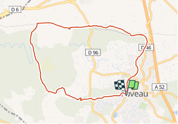
Trail Walking of 10.1 km to be discovered at Provence-Alpes-Côte d'Azur, Bouches-du-Rhône, Fuveau. This trail is proposed by ericberlin.
Description
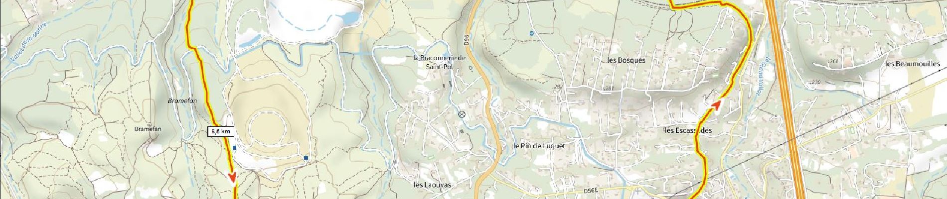
Départ halte routière de Fuveau. Passer l’école Roque Martine. Suivre l'ancienne voie ferrée Aubagne-Gardanne jusqu’au musée des transports, traverser la D96, longer la voie ferrée Trets-Gardanne suivre par le chemin de Bramefan le GR jusqu’au départ.
Pour info ce tour commence par l'ancienne gare de Fuveau détruite et devenue aujourd'hui la halte routière. Il emprunte plus ou moins l'ancienne voie ferrée qui allait de Aubagne à Gardanne. (partiellement convertie en voie verte sous le Moulin des Forges). Il passe par la gare désaffectée de la Barque où siège le musée des transports. Il revient par le GR Provence Energie qui passe par la centrale photovoltaïque de Bramefan.
sources:
Carte IGN 1950 https://remonterletemps.ign.fr/
https://urbasolar.com/references/terril-de-bramefan/https://fr.wikipedia.org/wiki/Ligne_d'Aubagne_à_La_Barque
https://fr.wikipedia.org/wiki/Ligne_de_Carnoules_à_Gardanne
http://jf-ber.roubaud.pagesperso-orange.fr/
https://www.mongr.fr/trouver-prochaine-randonnee/parcours/gr-de-pays-sentier-provence-mines-d-energies-petale-sud
Positioning
Comments
Trails nearby
![Mountain bike Mountain bike](https://static1.geolcdn.com/sitytour/trail-icons/202.png)
Mountain bike
![](/images/other/stat-length.png)
![](https://static1.geolcdn.com/siteimages/upload/files/16400158638029165_repeat_loop_refresh_sync_direction_icon.png)
![Walking Walking](https://static1.geolcdn.com/sitytour/trail-icons/101.png)
Walking
![](/images/other/stat-length.png)
![](https://static1.geolcdn.com/siteimages/upload/files/16400158638029165_repeat_loop_refresh_sync_direction_icon.png)
![Mountain bike Mountain bike](https://static1.geolcdn.com/sitytour/trail-icons/202.png)
Mountain bike
![](/images/other/stat-length.png)
![](https://static1.geolcdn.com/siteimages/upload/files/16400158638029165_repeat_loop_refresh_sync_direction_icon.png)
![Road bike Road bike](https://static1.geolcdn.com/sitytour/trail-icons/201.png)
Road bike
![](/images/other/stat-length.png)
![](https://static1.geolcdn.com/siteimages/upload/files/16400158638029165_repeat_loop_refresh_sync_direction_icon.png)
![Road bike Road bike](https://static1.geolcdn.com/sitytour/trail-icons/201.png)
Road bike
![](/images/other/stat-length.png)
![](https://static1.geolcdn.com/siteimages/upload/files/16400158638029165_repeat_loop_refresh_sync_direction_icon.png)