![](/images/other/stat-length.png)
![Trail Walking Monieux - St Hubert - Photo](https://media.geolcdn.com/t/1900/400/ext.pjpeg?maxdim=2&url=https%3A%2F%2Fservices.sitytrail.com%2FGeolivesWS%2FDownloadMedia.ashx%3FTrailID%3D307155%26Media%3Dfix__20140530091015.jpg)
St Hubert
MarcLEBARON
User
![Length](/images/other/stat-length.png)
Length
9.2 km
![Max alt](https://static1.geolcdn.com/siteimages/upload/files/1508320355ic_sort_altitude_max_24dp.png)
Max alt
888 m
![Uphill gradient](https://static1.geolcdn.com/siteimages/upload/files/1508320355ic_sort_den_pos_24dp.png)
Uphill gradient
257 m
![Km-Effort](/images/other/stat-length.png)
Km-Effort
12.7 km
![Min alt](https://static1.geolcdn.com/siteimages/upload/files/1508320355ic_sort_altitude_min_24dp.png)
Min alt
663 m
![Downhill gradient](https://static1.geolcdn.com/siteimages/upload/files/1508320355ic_sort_den_neg_24dp.png)
Downhill gradient
261 m
![Boucle](https://static1.geolcdn.com/siteimages/upload/files/16400158638029165_repeat_loop_refresh_sync_direction_icon.png)
Boucle
Yes
Creation date :
2014-12-10 00:00:00.0
Updated on :
2014-12-10 00:00:00.0
![Walking](https://static1.geolcdn.com/sitytour/trail-icons/101.png)
2h05
Difficulty : Easy
![Scan this QR Code to open this trail in the SityTrail application](https://capi.geolives.com/qq0zvz2zws4bq2lad0pu/sitytour/trails/307155/qr.png?size=200)
FREE GPS app for hiking
About
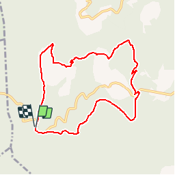
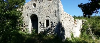
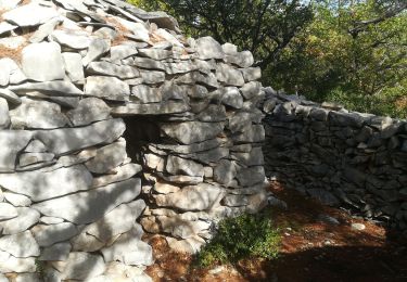
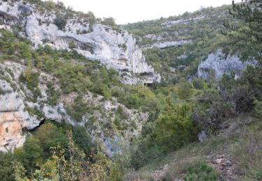
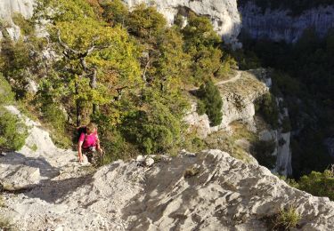
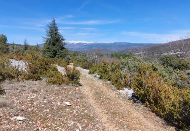
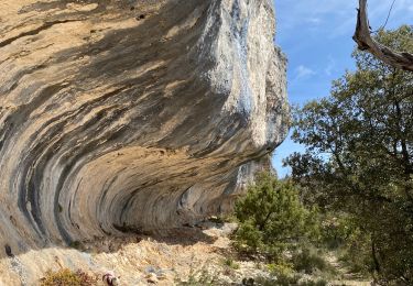
Trail Walking of 9.2 km to be discovered at Provence-Alpes-Côte d'Azur, Vaucluse, Monieux. This trail is proposed by MarcLEBARON.
Description
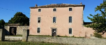
Boucle autour St Hubert.
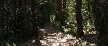
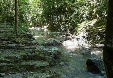
Sentier en grande partie forestier, agréable, à faire 1ère partie matinée.
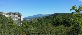
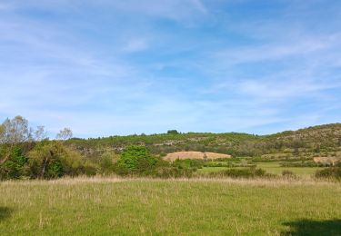
Peu de dénivelé, exception modeste de la descente et remontée sur Sicaude.
Sympa et accessible.
Positioning
Country:
France
Region :
Provence-Alpes-Côte d'Azur
Department/Province :
Vaucluse
Municipality :
Monieux
Location:
Unknown
Start:(Dec)
Start:(UTM)
685959 ; 4877394 (31T) N.
Comments
Trails nearby
![Trail Walking Monieux - Monieux - Gorges de la Nesque - Photo](https://media.geolcdn.com/t/375/260/ext.jpg?maxdim=2&url=https%3A%2F%2Fservices.sitytrail.com%2FGeolivesWS%2FDownloadMedia.ashx%3FTrailID%3D105313%26Media%3D9004_3.jpg)
![Walking Walking](https://static1.geolcdn.com/sitytour/trail-icons/101.png)
Monieux - Gorges de la Nesque
Walking
Medium
(1)
Monieux,
Provence-Alpes-Côte d'Azur,
Vaucluse,
France
![](/images/other/stat-length.png)
11.9 km | 19.1 km-effort
4h 30min
![](https://static1.geolcdn.com/siteimages/upload/files/16400158638029165_repeat_loop_refresh_sync_direction_icon.png)
Yes
![Trail Walking Monieux - gorge de la Nesque via GR9 - Photo](https://media.geolcdn.com/t/375/260/82e5f419-5076-448e-8031-28b99db04c60.jpg&format=jpg&maxdim=2)
![Walking Walking](https://static1.geolcdn.com/sitytour/trail-icons/101.png)
gorge de la Nesque via GR9
Walking
Medium
Monieux,
Provence-Alpes-Côte d'Azur,
Vaucluse,
France
![](/images/other/stat-length.png)
9.9 km | 15.6 km-effort
4h 55min
![](https://static1.geolcdn.com/siteimages/upload/files/16400158638029165_repeat_loop_refresh_sync_direction_icon.png)
Yes
![Trail Walking Blauvac - Passichaud Bergerie Pas du loup - Photo](https://media.geolcdn.com/t/375/260/61b46099-d063-4c59-b83e-1f9759560630.jpg&format=jpg&maxdim=2)
![Walking Walking](https://static1.geolcdn.com/sitytour/trail-icons/101.png)
Passichaud Bergerie Pas du loup
Walking
Easy
Blauvac,
Provence-Alpes-Côte d'Azur,
Vaucluse,
France
![](/images/other/stat-length.png)
7.5 km | 10.4 km-effort
2h 17min
![](https://static1.geolcdn.com/siteimages/upload/files/16400158638029165_repeat_loop_refresh_sync_direction_icon.png)
Yes
![Trail Walking Monieux - Les gorges de la Nesque par Monieux - Photo](https://media.geolcdn.com/t/375/260/ext.jpg?maxdim=2&url=https%3A%2F%2Fservices.sitytrail.com%2FGeolivesWS%2FDownloadMedia.ashx%3FTrailID%3D357382%26Media%3Dadcc4431-4f07-4bea-a3c7-6f92578268f2.JPG)
![Walking Walking](https://static1.geolcdn.com/sitytour/trail-icons/101.png)
Les gorges de la Nesque par Monieux
Walking
Medium
(3)
Monieux,
Provence-Alpes-Côte d'Azur,
Vaucluse,
France
![](/images/other/stat-length.png)
9.2 km | 14.5 km-effort
3h 34min
![](https://static1.geolcdn.com/siteimages/upload/files/16400158638029165_repeat_loop_refresh_sync_direction_icon.png)
Yes
![Trail Walking Monieux - Gorges de la Nesque - Photo](https://media.geolcdn.com/t/375/260/5f4cd60e-ee23-40c2-ab5d-4f02f4033710.jpg&format=jpg&maxdim=2)
![Walking Walking](https://static1.geolcdn.com/sitytour/trail-icons/101.png)
Gorges de la Nesque
Walking
Difficult
Monieux,
Provence-Alpes-Côte d'Azur,
Vaucluse,
France
![](/images/other/stat-length.png)
10.3 km | 16.5 km-effort
4h 36min
![](https://static1.geolcdn.com/siteimages/upload/files/16400158638029165_repeat_loop_refresh_sync_direction_icon.png)
Yes
![Trail Walking Monieux - Monieux la Nesque - Photo](https://media.geolcdn.com/t/375/260/4adaad69-bb88-46c5-8ab0-357cea984385.jpg&format=jpg&maxdim=2)
![Walking Walking](https://static1.geolcdn.com/sitytour/trail-icons/101.png)
Monieux la Nesque
Walking
Medium
Monieux,
Provence-Alpes-Côte d'Azur,
Vaucluse,
France
![](/images/other/stat-length.png)
7.1 km | 9.2 km-effort
2h 25min
![](https://static1.geolcdn.com/siteimages/upload/files/16400158638029165_repeat_loop_refresh_sync_direction_icon.png)
Yes
![Trail Walking Monieux - monnieux saint jean de durefort monnieux - Photo](https://media.geolcdn.com/t/375/260/8996ce90-161d-40fa-90f2-191c9eb4a1f0.jpg&format=jpg&maxdim=2)
![Walking Walking](https://static1.geolcdn.com/sitytour/trail-icons/101.png)
monnieux saint jean de durefort monnieux
Walking
Medium
Monieux,
Provence-Alpes-Côte d'Azur,
Vaucluse,
France
![](/images/other/stat-length.png)
16.1 km | 20 km-effort
6h 48min
![](https://static1.geolcdn.com/siteimages/upload/files/16400158638029165_repeat_loop_refresh_sync_direction_icon.png)
No
![Trail Walking Méthamis - Les Reīs Castelmourié - Photo](https://media.geolcdn.com/t/375/260/95e66f32-b6f1-4553-a1d1-7e794abbe86f.jpg&format=jpg&maxdim=2)
![Walking Walking](https://static1.geolcdn.com/sitytour/trail-icons/101.png)
Les Reīs Castelmourié
Walking
Easy
Méthamis,
Provence-Alpes-Côte d'Azur,
Vaucluse,
France
![](/images/other/stat-length.png)
5.4 km | 8.3 km-effort
1h 35min
![](https://static1.geolcdn.com/siteimages/upload/files/16400158638029165_repeat_loop_refresh_sync_direction_icon.png)
Yes
![Trail Walking Monieux - Les vieux village saint jean de Sault - Photo](https://media.geolcdn.com/t/375/260/67ee504a-25dc-4e0d-b790-38aee9e3492d.jpg&format=jpg&maxdim=2)
![Walking Walking](https://static1.geolcdn.com/sitytour/trail-icons/101.png)
Les vieux village saint jean de Sault
Walking
Very difficult
Monieux,
Provence-Alpes-Côte d'Azur,
Vaucluse,
France
![](/images/other/stat-length.png)
16.6 km | 23 km-effort
5h 49min
![](https://static1.geolcdn.com/siteimages/upload/files/16400158638029165_repeat_loop_refresh_sync_direction_icon.png)
Yes