![](/images/other/stat-length.png)
![Trail Walking Bellevigne-les-Châteaux - Circuit des châteaux de Bellevigne à Brézé - Photo](https://media.geolcdn.com/t/1900/400/ext.pjpeg?maxdim=2&url=https%3A%2F%2Fstatic1.geolcdn.com%2Fsiteimages%2Fupload%2Ffiles%2F1553511878bg_sport_marche.png)
Circuit des châteaux de Bellevigne à Brézé
neoroll44
User
![Length](/images/other/stat-length.png)
![Max alt](https://static1.geolcdn.com/siteimages/upload/files/1508320355ic_sort_altitude_max_24dp.png)
![Uphill gradient](https://static1.geolcdn.com/siteimages/upload/files/1508320355ic_sort_den_pos_24dp.png)
![Km-Effort](/images/other/stat-length.png)
![Min alt](https://static1.geolcdn.com/siteimages/upload/files/1508320355ic_sort_altitude_min_24dp.png)
![Downhill gradient](https://static1.geolcdn.com/siteimages/upload/files/1508320355ic_sort_den_neg_24dp.png)
![Boucle](https://static1.geolcdn.com/siteimages/upload/files/16400158638029165_repeat_loop_refresh_sync_direction_icon.png)
![Walking](https://static1.geolcdn.com/sitytour/trail-icons/101.png)
2h00
Difficulty : Medium
![Scan this QR Code to open this trail in the SityTrail application](https://capi.geolives.com/qq0zvz2zws4bq2lad0pu/sitytour/trails/3071196/qr.png?size=200)
FREE GPS app for hiking
About
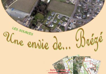
Trail Walking of 7.5 km to be discovered at Pays de la Loire, Maine-et-Loire, Bellevigne-les-Châteaux. This trail is proposed by neoroll44.
Description
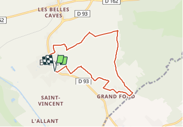
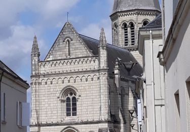
Départ du parvis de l'église de Brézé.
(D/A) Suivez la D93 (Rue du Maréchal de Maillé-Brézé) en direction de Saumur. Dépassez le parking du Château de Brézé.
(1) À l'intersection suivante, tournez à droite. Longez le mur d’enceinte du château et passez devant son ancienne entrée d’origine. Poursuivez le long du mur et découvrez un joli panorama viticole. Au croisement en T, tournez à droite et montez au point culminant du territoire, au pied d'un château d’eau... alimenté par une station de pompage.
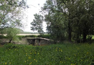
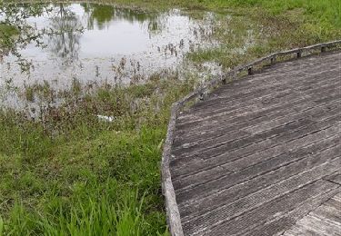
(2) Prenez le chemin le plus à gauche qui vous fera descendre au bas du vallon. Allez tout droit (Nord-Est) et ignorez tous les départs sur les côtés. Franchissez le Ru de la Bournée et tournez aussitôt à droite au croisement. Poursuivez jusqu'à rencontrer de nouveau le ru.
(3) Tournez alors à gauche avant le radier (ne franchissez pas le ru). Filez entre les champs jusqu’en lisière du bois. Là, tournerez à droite et cheminez plein Sud en ignorant les départs sur les côtés jusqu'au Carrefour de la Sablonnière (6 chemins).
(4) Prenez le deuxième chemin à gauche (Sud-Sud-Est). Passez sous une ligne électrique et atteignez le hameau de l'Étoile.
(5) Au croisement, continuez tout droit. Au croisement suivant, tournez à droite. Après une centaine de mètres, débouchez sur une route et suivez-la à droite pour atteindre rapidement le Château de Grand Fond. Continuez la route. Au bout, tournez à gauche puis aussitôt à droite dans la Rue du Château-Fouquet. Passez devant ledit château (un manoir du XVe siècle, remanié au XVIe et au XIXe).
(6) Au croisement, prenez le chemin de droite. Au croisement suivant, tournez à gauche. Au carrefour suivant, au pied de la chapelle du Château de la Ripaille (manoir du XVe avec son colombier du XVIe ; Chapelle Saint-Sébastien, reconstruite en 1860), tournez à droite. Allez tout droit (Nord-Ouest) jusqu'au carrefour suivant.
(7) Tournez alors à gauche suivez les vestiges de ce qui fut l’enceinte d’un clos. Sur la tour à l’angle de cette enceinte, cherchez les graffitis représentant des outils de vignerons. Vous retrouverez alors sous vos pieds le bitume qui vous conduira à une placette en herbe.
(8) Tournez à droite pour atteindre l’échauguette formant l’angle N-E du parc que vous avez longé au départ. Descendez à gauche, entre vigne et enceinte (vous êtes dans la Ruelle des Carmes). En bas, suivez à droite la Rue du Puits Aubert (prudence, c'est la rue la plus passagère du village). Sur votre droite, le parvis de l’église vous « dira » que la balade se termine ici (D/A).
Points of interest
Positioning
Comments
Trails nearby
![Trail On foot Bellevigne-les-Châteaux - À la confluence du Thouet et de la Dive - Photo](https://media.geolcdn.com/t/375/260/20b36c1d-1d41-40ea-bdce-136b5a57c77b.jpeg&format=jpg&maxdim=2)
![On foot On foot](https://static1.geolcdn.com/sitytour/trail-icons/100.png)
On foot
![](/images/other/stat-length.png)
![](https://static1.geolcdn.com/siteimages/upload/files/16400158638029165_repeat_loop_refresh_sync_direction_icon.png)
![Trail Walking Bellevigne-les-Châteaux - BREZE: LE MARAIS - Photo](https://media.geolcdn.com/t/375/260/30b90cc0-ecf1-4c2c-94d4-50d35ece45a0.jpg&format=jpg&maxdim=2)
![Walking Walking](https://static1.geolcdn.com/sitytour/trail-icons/101.png)
Walking
![](/images/other/stat-length.png)
![](https://static1.geolcdn.com/siteimages/upload/files/16400158638029165_repeat_loop_refresh_sync_direction_icon.png)
![Trail Walking Bellevigne-les-Châteaux - BELLEVIGNE LES CHÂTEAUX / BRÉZÉ: LA DIVE - Photo](https://media.geolcdn.com/t/375/260/142819c3-f42b-4a39-b0c8-288fef65e8ed.jpg&format=jpg&maxdim=2)
![Walking Walking](https://static1.geolcdn.com/sitytour/trail-icons/101.png)
Walking
![](/images/other/stat-length.png)
![](https://static1.geolcdn.com/siteimages/upload/files/16400158638029165_repeat_loop_refresh_sync_direction_icon.png)
![Trail Walking Bellevigne-les-Châteaux - BREZE: LA BOUCHARDIERE - Photo](https://media.geolcdn.com/t/375/260/2c925077-c9ca-4c18-90b3-0d0709f34746.jpg&format=jpg&maxdim=2)
![Walking Walking](https://static1.geolcdn.com/sitytour/trail-icons/101.png)
Walking
![](/images/other/stat-length.png)
![](https://static1.geolcdn.com/siteimages/upload/files/16400158638029165_repeat_loop_refresh_sync_direction_icon.png)
![Trail Walking Épieds - EPIEDS: Entre maraîchage, labourage et canotage - Photo](https://media.geolcdn.com/t/375/260/500c8c23-b1dd-4698-bea9-5fac1ebeabb5.jpg&format=jpg&maxdim=2)
![Walking Walking](https://static1.geolcdn.com/sitytour/trail-icons/101.png)
Walking
![](/images/other/stat-length.png)
![](https://static1.geolcdn.com/siteimages/upload/files/16400158638029165_repeat_loop_refresh_sync_direction_icon.png)
![Trail Walking Bellevigne-les-Châteaux - BREZE: circuit rose patrimoine - Photo](https://media.geolcdn.com/t/375/260/f0c1ab50-65f5-46d1-b557-0618528f162b.jpg&format=jpg&maxdim=2)
![Walking Walking](https://static1.geolcdn.com/sitytour/trail-icons/101.png)
Walking
![](/images/other/stat-length.png)
![](https://static1.geolcdn.com/siteimages/upload/files/16400158638029165_repeat_loop_refresh_sync_direction_icon.png)
![Trail Mountain bike Bellevigne-les-Châteaux - BELLEVIGNE LES CHÂTEAUX / BRÉZÉ: LE GRAND TOUR - Photo](https://media.geolcdn.com/t/375/260/054b1370-d22d-4ef0-8f89-221444296662.jpg&format=jpg&maxdim=2)
![Mountain bike Mountain bike](https://static1.geolcdn.com/sitytour/trail-icons/202.png)
Mountain bike
![](/images/other/stat-length.png)
![](https://static1.geolcdn.com/siteimages/upload/files/16400158638029165_repeat_loop_refresh_sync_direction_icon.png)
![Trail Walking Bellevigne-les-Châteaux - BELLEVIGNE LES CHÂTEAUX / BRÉZÉ: LES SOURCES - Photo](https://media.geolcdn.com/t/375/260/330af08e-b2f8-4eac-8e2a-c9d4c5ec9098.jpg&format=jpg&maxdim=2)
![Walking Walking](https://static1.geolcdn.com/sitytour/trail-icons/101.png)
Walking
![](/images/other/stat-length.png)
![](https://static1.geolcdn.com/siteimages/upload/files/16400158638029165_repeat_loop_refresh_sync_direction_icon.png)
![Trail Walking Bellevigne-les-Châteaux - BELLEVIGNE LES CHÂTEAUX / BRÉZÉ: 1-2-3 CHÂTEAUX - Photo](https://media.geolcdn.com/t/375/260/33b49771-4884-4922-abab-b1028a97b7b7.jpg&format=jpg&maxdim=2)
![Walking Walking](https://static1.geolcdn.com/sitytour/trail-icons/101.png)
Walking
![](/images/other/stat-length.png)
![](https://static1.geolcdn.com/siteimages/upload/files/16400158638029165_repeat_loop_refresh_sync_direction_icon.png)