![](/images/other/stat-length.png)
![Trail Walking Combovin - La Grande Dent combo vin - Photo](https://media.geolcdn.com/t/1900/400/ext.pjpeg?maxdim=2&url=https%3A%2F%2Fstatic1.geolcdn.com%2Fsiteimages%2Fupload%2Ffiles%2F1553511878bg_sport_marche.png)
La Grande Dent combo vin
alinetpierre
User
![Length](/images/other/stat-length.png)
Length
16.6 km
![Max alt](https://static1.geolcdn.com/siteimages/upload/files/1508320355ic_sort_altitude_max_24dp.png)
Max alt
1003 m
![Uphill gradient](https://static1.geolcdn.com/siteimages/upload/files/1508320355ic_sort_den_pos_24dp.png)
Uphill gradient
823 m
![Km-Effort](/images/other/stat-length.png)
Km-Effort
28 km
![Min alt](https://static1.geolcdn.com/siteimages/upload/files/1508320355ic_sort_altitude_min_24dp.png)
Min alt
365 m
![Downhill gradient](https://static1.geolcdn.com/siteimages/upload/files/1508320355ic_sort_den_neg_24dp.png)
Downhill gradient
823 m
![Boucle](https://static1.geolcdn.com/siteimages/upload/files/16400158638029165_repeat_loop_refresh_sync_direction_icon.png)
Boucle
Yes
Creation date :
2022-01-22 08:57:23.0
Updated on :
2022-01-22 14:09:03.085
![Walking](https://static1.geolcdn.com/sitytour/trail-icons/101.png)
4h14
Difficulty : Difficult
![Scan this QR Code to open this trail in the SityTrail application](https://capi.geolives.com/qq0zvz2zws4bq2lad0pu/sitytour/trails/3060239/qr.png?size=200)
FREE GPS app for hiking
About
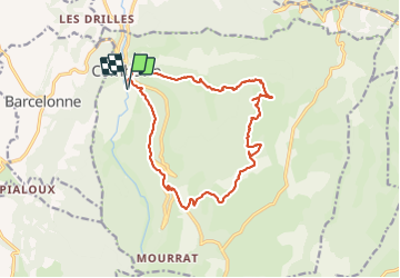
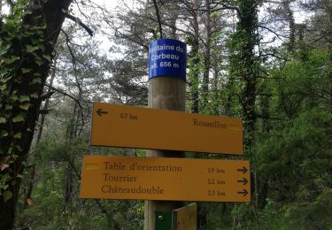
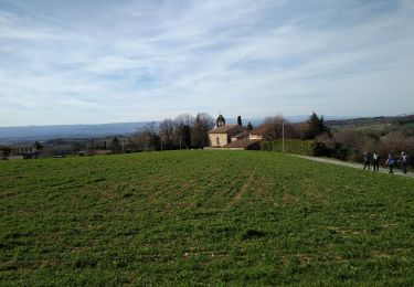
Trail Walking of 16.6 km to be discovered at Auvergne-Rhône-Alpes, Drôme, Combovin. This trail is proposed by alinetpierre.
Description
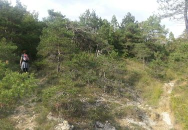
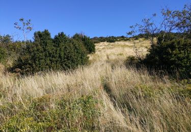
Départ de combovin cimetière, attention peu de sentiers, ne pas se perdre dans les pâturages, des passages dans les buis. Bonne balade
Positioning
Country:
France
Region :
Auvergne-Rhône-Alpes
Department/Province :
Drôme
Municipality :
Combovin
Location:
Unknown
Start:(Dec)
Start:(UTM)
664088 ; 4970753 (31T) N.
Comments
Trails nearby
![Trail Walking Barcelonne - Barcelonne - autour de la Tour - Description et photos - Photo](https://media.geolcdn.com/t/375/260/ext.jpg?maxdim=2&url=https%3A%2F%2Fservices.sitytrail.com%2FGeolivesWS%2FDownloadMedia.ashx%3FTrailID%3D639966%26Media%3Dfix__20161002163239.jpg)
![Walking Walking](https://static1.geolcdn.com/sitytour/trail-icons/101.png)
Barcelonne - autour de la Tour - Description et photos
Walking
Easy
(3)
Barcelonne,
Auvergne-Rhône-Alpes,
Drôme,
France
![](/images/other/stat-length.png)
4.3 km | 6.6 km-effort
1h 29min
![](https://static1.geolcdn.com/siteimages/upload/files/16400158638029165_repeat_loop_refresh_sync_direction_icon.png)
Yes
![Trail Walking Châteaudouble - Le pont des sarazins par la fontaine des corbeaux - Photo](https://media.geolcdn.com/t/375/260/1f3934ff-cd5e-4a15-93b4-c6f716008382.jpg&format=jpg&maxdim=2)
![Walking Walking](https://static1.geolcdn.com/sitytour/trail-icons/101.png)
Le pont des sarazins par la fontaine des corbeaux
Walking
Medium
(1)
Châteaudouble,
Auvergne-Rhône-Alpes,
Drôme,
France
![](/images/other/stat-length.png)
6.4 km | 11.2 km-effort
2h 57min
![](https://static1.geolcdn.com/siteimages/upload/files/16400158638029165_repeat_loop_refresh_sync_direction_icon.png)
No
![Trail Walking Barcelonne - Barcelonne-Combivin-Chapelle St Marguerite - Photo](https://media.geolcdn.com/t/375/260/ext.jpg?maxdim=2&url=https%3A%2F%2Fservices.sitytrail.com%2FGeolivesWS%2FDownloadMedia.ashx%3FTrailID%3D272339%26Media%3D20140430171101.jpg)
![Walking Walking](https://static1.geolcdn.com/sitytour/trail-icons/101.png)
Barcelonne-Combivin-Chapelle St Marguerite
Walking
Easy
(1)
Barcelonne,
Auvergne-Rhône-Alpes,
Drôme,
France
![](/images/other/stat-length.png)
8.7 km | 13.5 km-effort
2h 20min
![](https://static1.geolcdn.com/siteimages/upload/files/16400158638029165_repeat_loop_refresh_sync_direction_icon.png)
Yes
![Trail Walking La Baume-Cornillane - Pas du Pont - Pas de la Croix - Pas du Buis - Photo](https://media.geolcdn.com/t/375/260/ext.jpg?maxdim=2&url=https%3A%2F%2Fservices.sitytrail.com%2FGeolivesWS%2FDownloadMedia.ashx%3FTrailID%3D99687%26Media%3D20120128162324.jpeg)
![Walking Walking](https://static1.geolcdn.com/sitytour/trail-icons/101.png)
Pas du Pont - Pas de la Croix - Pas du Buis
Walking
Medium
(2)
La Baume-Cornillane,
Auvergne-Rhône-Alpes,
Drôme,
France
![](/images/other/stat-length.png)
10.3 km | 18 km-effort
2h 52min
![](https://static1.geolcdn.com/siteimages/upload/files/16400158638029165_repeat_loop_refresh_sync_direction_icon.png)
Yes
![Trail Walking La Baume-Cornillane - pas du pont - Photo](https://media.geolcdn.com/t/375/260/ext.jpg?maxdim=2&url=https%3A%2F%2Fstatic1.geolcdn.com%2Fsiteimages%2Fupload%2Ffiles%2F1553511878bg_sport_marche.png)
![Walking Walking](https://static1.geolcdn.com/sitytour/trail-icons/101.png)
pas du pont
Walking
Easy
(1)
La Baume-Cornillane,
Auvergne-Rhône-Alpes,
Drôme,
France
![](/images/other/stat-length.png)
6.9 km | 9.8 km-effort
3h 22min
![](https://static1.geolcdn.com/siteimages/upload/files/16400158638029165_repeat_loop_refresh_sync_direction_icon.png)
Yes
![Trail Walking Chabeuil - Sainte Baume 4ème tronçon Chabeuil/ la Vacherie en passant par Léoncel - Photo](https://media.geolcdn.com/t/375/260/ext.jpg?maxdim=2&url=https%3A%2F%2Fstatic1.geolcdn.com%2Fsiteimages%2Fupload%2Ffiles%2F1553511878bg_sport_marche.png)
![Walking Walking](https://static1.geolcdn.com/sitytour/trail-icons/101.png)
Sainte Baume 4ème tronçon Chabeuil/ la Vacherie en passant par Léoncel
Walking
Very easy
(1)
Chabeuil,
Auvergne-Rhône-Alpes,
Drôme,
France
![](/images/other/stat-length.png)
23 km | 34 km-effort
7h 27min
![](https://static1.geolcdn.com/siteimages/upload/files/16400158638029165_repeat_loop_refresh_sync_direction_icon.png)
No
![Trail Walking Peyrus - pont des sarrasins, faucon, piaroux - Photo](https://media.geolcdn.com/t/375/260/2681339b-63d6-4100-8047-95b258aa19f5.jpg&format=jpg&maxdim=2)
![Walking Walking](https://static1.geolcdn.com/sitytour/trail-icons/101.png)
pont des sarrasins, faucon, piaroux
Walking
Very difficult
Peyrus,
Auvergne-Rhône-Alpes,
Drôme,
France
![](/images/other/stat-length.png)
8.3 km | 14.3 km-effort
3h 2min
![](https://static1.geolcdn.com/siteimages/upload/files/16400158638029165_repeat_loop_refresh_sync_direction_icon.png)
Yes
![Trail Road bike Barcelonne - 03-05-22-14693810 - Photo](https://media.geolcdn.com/t/375/260/ext.jpg?maxdim=2&url=https%3A%2F%2Fstatic1.geolcdn.com%2Fsiteimages%2Fupload%2Ffiles%2F1524743154velo.jpg)
![Road bike Road bike](https://static1.geolcdn.com/sitytour/trail-icons/201.png)
03-05-22-14693810
Road bike
Very difficult
(1)
Barcelonne,
Auvergne-Rhône-Alpes,
Drôme,
France
![](/images/other/stat-length.png)
67 km | 88 km-effort
5h 20min
![](https://static1.geolcdn.com/siteimages/upload/files/16400158638029165_repeat_loop_refresh_sync_direction_icon.png)
No
![Trail Walking Combovin - COMBOVIN 2023 - Photo](https://media.geolcdn.com/t/375/260/9fc4d486-081f-4035-b6ba-32d08b6cde19.jpg&format=jpg&maxdim=2)
![Walking Walking](https://static1.geolcdn.com/sitytour/trail-icons/101.png)
COMBOVIN 2023
Walking
Medium
Combovin,
Auvergne-Rhône-Alpes,
Drôme,
France
![](/images/other/stat-length.png)
15.4 km | 23 km-effort
5h 20min
![](https://static1.geolcdn.com/siteimages/upload/files/16400158638029165_repeat_loop_refresh_sync_direction_icon.png)
No