![](/images/other/stat-length.png)
![Trail Walking Opwijk - 20220416 Hyacintentocht 12 km - Photo](https://media.geolcdn.com/t/1900/400/ae2ac5aa-00d1-4a9a-96be-89b4020581ac.webp&format=pjpeg&maxdim=2)
20220416 Hyacintentocht 12 km
ElGino
User
![Length](/images/other/stat-length.png)
Length
12.9 km
![Max alt](https://static1.geolcdn.com/siteimages/upload/files/1508320355ic_sort_altitude_max_24dp.png)
Max alt
82 m
![Uphill gradient](https://static1.geolcdn.com/siteimages/upload/files/1508320355ic_sort_den_pos_24dp.png)
Uphill gradient
118 m
![Km-Effort](/images/other/stat-length.png)
Km-Effort
14.4 km
![Min alt](https://static1.geolcdn.com/siteimages/upload/files/1508320355ic_sort_altitude_min_24dp.png)
Min alt
35 m
![Downhill gradient](https://static1.geolcdn.com/siteimages/upload/files/1508320355ic_sort_den_neg_24dp.png)
Downhill gradient
117 m
![Boucle](https://static1.geolcdn.com/siteimages/upload/files/16400158638029165_repeat_loop_refresh_sync_direction_icon.png)
Boucle
Yes
Creation date :
2022-01-21 13:14:59.889
Updated on :
2022-01-21 17:15:27.943
![Walking](https://static1.geolcdn.com/sitytour/trail-icons/101.png)
2h06
Difficulty : Medium
![Scan this QR Code to open this trail in the SityTrail application](https://capi.geolives.com/qq0zvz2zws4bq2lad0pu/sitytour/trails/3059472/qr.png?size=200)
FREE GPS app for hiking
About
Trail Walking of 12.9 km to be discovered at Flanders, Flemish Brabant, Opwijk. This trail is proposed by ElGino.
Description
Mazenzele dorp vertrek langs wijk en splitsen naar rechts richting OUde Heirbaan en lus in Kravaal bos. Terugkeren via achterkant Vedderboom 12.86 km wa (lus: 12,86 - 8,4 = 4,46km) = lus 5 km.
Positioning
Country:
Belgium
Region :
Flanders
Department/Province :
Flemish Brabant
Municipality :
Opwijk
Location:
Mazenzele
Start:(Dec)
Start:(UTM)
582294 ; 5644099 (31U) N.
Comments
Trails nearby
![Trail Horseback riding Opwijk - Wikiloc - Meldert vanuit De Kleine Deugd - Photo](https://media.geolcdn.com/t/375/260/ext.jpg?maxdim=2&url=https%3A%2F%2Fstatic1.geolcdn.com%2Fsiteimages%2Fupload%2Ffiles%2F1524743154cheval.jpg)
![Horseback riding Horseback riding](https://static1.geolcdn.com/sitytour/trail-icons/301.png)
Wikiloc - Meldert vanuit De Kleine Deugd
Horseback riding
Easy
(1)
Opwijk,
Flanders,
Flemish Brabant,
Belgium
![](/images/other/stat-length.png)
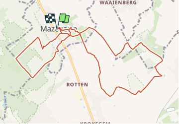
12.3 km | 14 km-effort
1h 57min
![](https://static1.geolcdn.com/siteimages/upload/files/16400158638029165_repeat_loop_refresh_sync_direction_icon.png)
Yes
![Trail On foot Aalst - Kersenwandeling - Photo](https://media.geolcdn.com/t/375/260/ea2bda03-7aab-439e-ac2f-d6e170d9c15f.jpeg&format=jpg&maxdim=2)
![On foot On foot](https://static1.geolcdn.com/sitytour/trail-icons/100.png)
Kersenwandeling
On foot
Easy
Aalst,
Flanders,
East Flanders,
Belgium
![](/images/other/stat-length.png)
5.1 km | 5.8 km-effort
1h 18min
![](https://static1.geolcdn.com/siteimages/upload/files/16400158638029165_repeat_loop_refresh_sync_direction_icon.png)
Yes
![Trail On foot Lebbeke - Mennenpad - Photo](https://media.geolcdn.com/t/375/260/9ca09073-979e-439c-9e92-d1334cfb6bb5.jpeg&format=jpg&maxdim=2)
![On foot On foot](https://static1.geolcdn.com/sitytour/trail-icons/100.png)
![Trail Walking Asse - Asse 25 km - Photo](https://media.geolcdn.com/t/375/260/93373654-1789-4a22-a980-4e4078e012f6.jpg&format=jpg&maxdim=2)
![Walking Walking](https://static1.geolcdn.com/sitytour/trail-icons/101.png)
![Trail Walking Asse - S-GR Groene Gordel: Mollem - Ternat - Photo](https://media.geolcdn.com/t/375/260/6faef7af-0d0f-4faa-bb47-f1d7e98a3199.jpeg&format=jpg&maxdim=2)
![Walking Walking](https://static1.geolcdn.com/sitytour/trail-icons/101.png)
S-GR Groene Gordel: Mollem - Ternat
Walking
Medium
Asse,
Flanders,
Flemish Brabant,
Belgium
![](/images/other/stat-length.png)
16.9 km | 19.4 km-effort
4h 24min
![](https://static1.geolcdn.com/siteimages/upload/files/16400158638029165_repeat_loop_refresh_sync_direction_icon.png)
No
![Trail Walking Asse - Asse 10,7 km - Photo](https://media.geolcdn.com/t/375/260/0cbdcab9-dd9e-496b-b40e-0779d93b5c23.jpg&format=jpg&maxdim=2)
![Walking Walking](https://static1.geolcdn.com/sitytour/trail-icons/101.png)
Asse 10,7 km
Walking
Easy
(1)
Asse,
Flanders,
Flemish Brabant,
Belgium
![](/images/other/stat-length.png)
10.7 km | 12.9 km-effort
2h 23min
![](https://static1.geolcdn.com/siteimages/upload/files/16400158638029165_repeat_loop_refresh_sync_direction_icon.png)
Yes
![Trail Walking Asse - Asse Kravaalbos 6,1 km - Photo](https://media.geolcdn.com/t/375/260/25a33a83-112b-4dd2-b149-e23b8049088b.jpg&format=jpg&maxdim=2)
![Walking Walking](https://static1.geolcdn.com/sitytour/trail-icons/101.png)
Asse Kravaalbos 6,1 km
Walking
Very easy
Asse,
Flanders,
Flemish Brabant,
Belgium
![](/images/other/stat-length.png)
6.1 km | 7.1 km-effort
1h 35min
![](https://static1.geolcdn.com/siteimages/upload/files/16400158638029165_repeat_loop_refresh_sync_direction_icon.png)
Yes
![Trail Walking Asse - Asbeek 8 km - Photo](https://media.geolcdn.com/t/375/260/c9378bb3-5963-4357-b9f0-3509a536491f.jpg&format=jpg&maxdim=2)
![Walking Walking](https://static1.geolcdn.com/sitytour/trail-icons/101.png)
Asbeek 8 km
Walking
Easy
Asse,
Flanders,
Flemish Brabant,
Belgium
![](/images/other/stat-length.png)
8.3 km | 9.5 km-effort
2h 1min
![](https://static1.geolcdn.com/siteimages/upload/files/16400158638029165_repeat_loop_refresh_sync_direction_icon.png)
Yes
![Trail Walking Aalst - 20221204 Verkenning Baardegem Winninck - Photo](https://media.geolcdn.com/t/375/260/2707ccb6-80d7-4bb7-8678-8ecaad5c771c.jpg&format=jpg&maxdim=2)
![Walking Walking](https://static1.geolcdn.com/sitytour/trail-icons/101.png)
20221204 Verkenning Baardegem Winninck
Walking
Medium
Aalst,
Flanders,
East Flanders,
Belgium
![](/images/other/stat-length.png)
5.6 km | 6.1 km-effort
1h 14min
![](https://static1.geolcdn.com/siteimages/upload/files/16400158638029165_repeat_loop_refresh_sync_direction_icon.png)
Yes