Trail Road bike Cavaillon - Cavaillon - Le pont Julien et retour (boucle) - Photo

Cavaillon - Le pont Julien et retour (boucle)

© OpenStreetMap contributors
Length
Length
54 km
Max alt
Max alt
284 m
Uphill gradient
Uphill gradient
504 m
Km-Effort
Km-Effort  
61 km
Min alt
Min alt
72 m
Downhill gradient
Downhill gradient
504 m
Boucle
Boucle
Yes
Creation date :
2022-01-20 19:27:23.196
Updated on :
2022-02-06 10:48:57.27

(0 Reviews)

Road bike
Road bike
3h42
Difficulty : Very difficult

Scan this QR Code to open this trail in the SityTrail application

FREE GPS app for hiking

Logo SityTrail SityTrail

IGN / Geographical institutes

Download SityTrail from the App Store Download SityTrail from Google Play

Logo SityTrail SityTrail World

The world is yours!

Download SityTrail from the App Store Download SityTrail from Google Play Download SityTrail on Huawei AppGallery

About

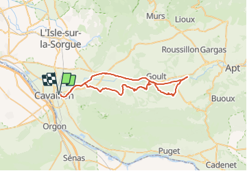
Trail Road bike of 54 km to be discovered at Provence-Alpes-Côte d'Azur, Vaucluse, Cavaillon. This trail is proposed by Magali Sat.

Description

A l'aller, de Cavaillon à Robion par la nouvelle voie verte, puis petites routes jusqu'au pont Julien. Au retour, voie verte du Calavon du pont Julien à Cavaillon. Le dénivellé est essentiellement sur la portion "aller". Pour l'éviter, faire l'aller retour sur la voie verte.

Elevation profile

Positioning

Country:
France
Region :
Provence-Alpes-Côte d'Azur
Department/Province :
Vaucluse
Municipality :
Cavaillon
Location:
Unknown
Start:(UTM)
664821 ; 4855757 (31T) N.

Trails nearby

Trail Cycle Cavaillon - Autour du Luberon à vélo - Photo
Cycle
GUIDE+

Cycle

Difficult
(4)
Cavaillon, Provence-Alpes-Côte d'Azur, Vaucluse, France
236 km | 285 km-effort
15h 46min
Yes
Trail Cycle Cavaillon - Parcours n°3 - Cavaillon - Photo
Cycle
GUIDE+

Cycle

Easy
(2)
Cavaillon, Provence-Alpes-Côte d'Azur, Vaucluse, France
45 km | 50 km-effort
2h 55min
No
Trail Cycle Cavaillon - Parcours n°1 - Cavaillon - Photo
Cycle
GUIDE+

Cycle

Difficult
(2)
Cavaillon, Provence-Alpes-Côte d'Azur, Vaucluse, France
33 km | 41 km-effort
2h 21min
Yes
Trail Walking Taillades - Par la Gorge de Badarel et les Rochers de Baude - Photo
Walking
tracegps

Walking

Medium
(3)
Taillades, Provence-Alpes-Côte d'Azur, Vaucluse, France
8 km | 14.7 km-effort
4h 0min
Yes
Trail Walking Taillades - taillades - Photo
Walking
fireman84

Walking

Very easy
(1)
Taillades, Provence-Alpes-Côte d'Azur, Vaucluse, France
7.6 km | 9.8 km-effort
1h 36min
Yes
Trail Walking Taillades - Les Taillades-De la source du Boulon au Castelas - Gorge de Badarel sous la neige - Photo
Walking
tracegps

Walking

Difficult
(1)
Taillades, Provence-Alpes-Côte d'Azur, Vaucluse, France
7 km | 10.8 km-effort
3h 0min
Yes
Trail Walking Taillades - Taillades Badarel  Brayette Robion - Photo
Walking
kephas

Walking

Difficult
(1)
Taillades, Provence-Alpes-Côte d'Azur, Vaucluse, France
10.6 km | 17.6 km-effort
3h 41min
Yes
Trail Walking Cheval-Blanc - bergerie/badarel - Photo
Walking
fireman84

Walking

Medium
(1)
Cheval-Blanc, Provence-Alpes-Côte d'Azur, Vaucluse, France
9.9 km | 16 km-effort
3h 20min
Yes
Trail Mountain bike Cheval-Blanc - vidok vtt - Photo
Mountain bike
fireman84

Mountain bike

Difficult
(2)
Cheval-Blanc, Provence-Alpes-Côte d'Azur, Vaucluse, France
17.4 km | 24 km-effort
1h 36min
Yes


Close
My subscriptions