![](/images/other/stat-length.png)
![Trail On foot Le Castellet - Château Renard by DAL - Photo](https://media.geolcdn.com/t/1900/400/ext.pjpeg?maxdim=2&url=https%3A%2F%2Fstatic1.geolcdn.com%2Fsiteimages%2Fupload%2Ffiles%2F1545311037marcheuse_200dpi.jpg)
Château Renard by DAL
dany83ynad
User
![Length](/images/other/stat-length.png)
Length
11.6 km
![Max alt](https://static1.geolcdn.com/siteimages/upload/files/1508320355ic_sort_altitude_max_24dp.png)
Max alt
511 m
![Uphill gradient](https://static1.geolcdn.com/siteimages/upload/files/1508320355ic_sort_den_pos_24dp.png)
Uphill gradient
259 m
![Km-Effort](/images/other/stat-length.png)
Km-Effort
15 km
![Min alt](https://static1.geolcdn.com/siteimages/upload/files/1508320355ic_sort_altitude_min_24dp.png)
Min alt
362 m
![Downhill gradient](https://static1.geolcdn.com/siteimages/upload/files/1508320355ic_sort_den_neg_24dp.png)
Downhill gradient
259 m
![Boucle](https://static1.geolcdn.com/siteimages/upload/files/16400158638029165_repeat_loop_refresh_sync_direction_icon.png)
Boucle
Yes
Creation date :
2022-01-19 08:34:47.782
Updated on :
2022-01-19 22:56:18.857
![On foot](https://static1.geolcdn.com/sitytour/trail-icons/100.png)
3h24
Difficulty : Easy
![Scan this QR Code to open this trail in the SityTrail application](https://capi.geolives.com/qq0zvz2zws4bq2lad0pu/sitytour/trails/3056947/qr.png?size=200)
FREE GPS app for hiking
About
Trail On foot of 11.6 km to be discovered at Provence-Alpes-Côte d'Azur, Var, Le Castellet. This trail is proposed by dany83ynad.
Description
Circuit facile avec de nombreux points de tournage des films de Jean de Florette et Manon des Sources de Claude Berry (1986)
Positioning
Country:
France
Region :
Provence-Alpes-Côte d'Azur
Department/Province :
Var
Municipality :
Le Castellet
Location:
Unknown
Start:(Dec)
Start:(UTM)
724119 ; 4793640 (31T) N.
Comments
Trails nearby
![Trail Walking Le Beausset - Trace_Quatre_Freres - Photo](https://media.geolcdn.com/t/375/260/a076bf67-1e95-4bda-8264-007e64206af1.jpg&format=jpg&maxdim=2)
![Walking Walking](https://static1.geolcdn.com/sitytour/trail-icons/101.png)
Trace_Quatre_Freres
Walking
Very difficult
(1)
Le Beausset,
Provence-Alpes-Côte d'Azur,
Var,
France
![](/images/other/stat-length.png)
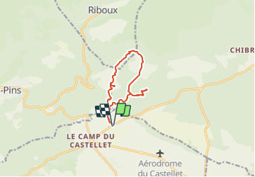
14.8 km | 19.6 km-effort
4h 26min
![](https://static1.geolcdn.com/siteimages/upload/files/16400158638029165_repeat_loop_refresh_sync_direction_icon.png)
Yes
![Trail Walking Le Castellet - SityTrail - 2361987 - begude - Photo](https://media.geolcdn.com/t/375/260/dbe90af6-979b-4145-807f-db327fb40379.jpg&format=jpg&maxdim=2)
![Walking Walking](https://static1.geolcdn.com/sitytour/trail-icons/101.png)
SityTrail - 2361987 - begude
Walking
Medium
(1)
Le Castellet,
Provence-Alpes-Côte d'Azur,
Var,
France
![](/images/other/stat-length.png)
11.5 km | 15.1 km-effort
4h 0min
![](https://static1.geolcdn.com/siteimages/upload/files/16400158638029165_repeat_loop_refresh_sync_direction_icon.png)
Yes
![Trail Walking Le Beausset - Tête du Cade par abime de Maramouyé - Photo](https://media.geolcdn.com/t/375/260/ext.jpg?maxdim=2&url=https%3A%2F%2Fservices.sitytrail.com%2FGeolivesWS%2FDownloadMedia.ashx%3FTrailID%3D1038187%26Media%3Dfix__20180911112303.jpg)
![Walking Walking](https://static1.geolcdn.com/sitytour/trail-icons/101.png)
Tête du Cade par abime de Maramouyé
Walking
Very easy
(1)
Le Beausset,
Provence-Alpes-Côte d'Azur,
Var,
France
![](/images/other/stat-length.png)
12.4 km | 16.1 km-effort
3h 36min
![](https://static1.geolcdn.com/siteimages/upload/files/16400158638029165_repeat_loop_refresh_sync_direction_icon.png)
Yes
![Trail Mountain bike Signes - De Chibron à Riboux et au Grand Vallon, sur le versant sud de la Sainte Baume - Photo](https://media.geolcdn.com/t/375/260/ext.jpg?maxdim=2&url=https%3A%2F%2Fservices.sitytrail.com%2FGeolivesWS%2FDownloadMedia.ashx%3FTrailID%3D105192%26Media%3D8829_6.jpg)
![Mountain bike Mountain bike](https://static1.geolcdn.com/sitytour/trail-icons/202.png)
De Chibron à Riboux et au Grand Vallon, sur le versant sud de la Sainte Baume
Mountain bike
Medium
(1)
Signes,
Provence-Alpes-Côte d'Azur,
Var,
France
![](/images/other/stat-length.png)
30 km | 39 km-effort
3h 0min
![](https://static1.geolcdn.com/siteimages/upload/files/16400158638029165_repeat_loop_refresh_sync_direction_icon.png)
Yes
![Trail Walking Cuges-les-Pins - Jean de lorette, grotte et mémorial - Photo](https://media.geolcdn.com/t/375/260/7f0fa6ce-b146-4d44-9642-97b327cde2ed.jpg&format=jpg&maxdim=2)
![Walking Walking](https://static1.geolcdn.com/sitytour/trail-icons/101.png)
Jean de lorette, grotte et mémorial
Walking
Difficult
(1)
Cuges-les-Pins,
Provence-Alpes-Côte d'Azur,
Bouches-du-Rhône,
France
![](/images/other/stat-length.png)
11.2 km | 14.6 km-effort
3h 18min
![](https://static1.geolcdn.com/siteimages/upload/files/16400158638029165_repeat_loop_refresh_sync_direction_icon.png)
Yes
![Trail Walking Riboux - Riboux - Forêt de Malaucène - Photo](https://media.geolcdn.com/t/375/260/ext.jpg?maxdim=2&url=https%3A%2F%2Fservices.sitytrail.com%2FGeolivesWS%2FDownloadMedia.ashx%3FTrailID%3D103921%26Media%3D6772_2.jpg)
![Walking Walking](https://static1.geolcdn.com/sitytour/trail-icons/101.png)
Riboux - Forêt de Malaucène
Walking
Medium
(4)
Riboux,
Provence-Alpes-Côte d'Azur,
Var,
France
![](/images/other/stat-length.png)
12.2 km | 15.2 km-effort
2h 40min
![](https://static1.geolcdn.com/siteimages/upload/files/16400158638029165_repeat_loop_refresh_sync_direction_icon.png)
Yes
![Trail Walking Cuges-les-Pins - cuges barres de castillon OK coral - Photo](https://media.geolcdn.com/t/375/260/886762c3-484d-410a-9360-386115a5dec4.jpg&format=jpg&maxdim=2)
![Walking Walking](https://static1.geolcdn.com/sitytour/trail-icons/101.png)
cuges barres de castillon OK coral
Walking
Medium
(1)
Cuges-les-Pins,
Provence-Alpes-Côte d'Azur,
Bouches-du-Rhône,
France
![](/images/other/stat-length.png)
10.9 km | 14.9 km-effort
5h 54min
![](https://static1.geolcdn.com/siteimages/upload/files/16400158638029165_repeat_loop_refresh_sync_direction_icon.png)
Yes
![Trail Walking Signes - grotte du mounoi signes - Photo](https://media.geolcdn.com/t/375/260/ext.jpg?maxdim=2&url=https%3A%2F%2Fservices.sitytrail.com%2FGeolivesWS%2FDownloadMedia.ashx%3FTrailID%3D266184%26Media%3Dfix__20140413111146.jpg)
![Walking Walking](https://static1.geolcdn.com/sitytour/trail-icons/101.png)
grotte du mounoi signes
Walking
Medium
(1)
Signes,
Provence-Alpes-Côte d'Azur,
Var,
France
![](/images/other/stat-length.png)
17 km | 21 km-effort
4h 45min
![](https://static1.geolcdn.com/siteimages/upload/files/16400158638029165_repeat_loop_refresh_sync_direction_icon.png)
Yes
![Trail Walking Le Beausset - la tête de cade. Maison des 4 frères le Beausset - Photo](https://media.geolcdn.com/t/375/260/0d9e1f30-3a4b-476b-b15d-3d4d5c048e2b.jpg&format=jpg&maxdim=2)
![Walking Walking](https://static1.geolcdn.com/sitytour/trail-icons/101.png)
la tête de cade. Maison des 4 frères le Beausset
Walking
Difficult
Le Beausset,
Provence-Alpes-Côte d'Azur,
Var,
France
![](/images/other/stat-length.png)
9.7 km | 12.4 km-effort
3h 34min
![](https://static1.geolcdn.com/siteimages/upload/files/16400158638029165_repeat_loop_refresh_sync_direction_icon.png)
No