Trail On foot Wingles - WINGLES courte 9km - Photo
 fif59280
fif59280

User

© OpenStreetMap contributors
Length
Length
9 km
Max alt
Max alt
35 m
Uphill gradient
Uphill gradient
70 m
Km-Effort
Km-Effort  
10 km
Min alt
Min alt
13 m
Downhill gradient
Downhill gradient
68 m
Boucle
Boucle
Yes
Creation date :
2022-01-17 17:39:31.872
Updated on :
2024-01-29 17:23:16.647

(0 Reviews)

On foot
On foot
2h15
Difficulty : Easy

Scan this QR Code to open this trail in the SityTrail application

FREE GPS app for hiking

Logo SityTrail SityTrail

IGN / Geographical institutes

Download SityTrail from the App Store Download SityTrail from Google Play

Logo SityTrail SityTrail World

The world is yours!

Download SityTrail from the App Store Download SityTrail from Google Play Download SityTrail on Huawei AppGallery

About

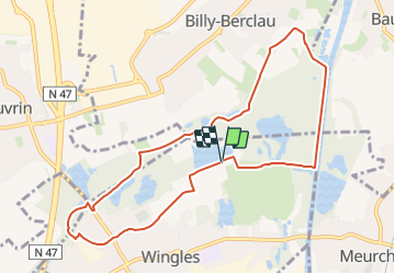
Trail On foot of 9 km to be discovered at Hauts-de-France, Pas-de-Calais, Wingles. This trail is proposed by fif59280.

Description

Départ de la base de loisirs rue René CLAIR. Rejoindre l'arrière du cimetière et aller tout droit jusqu'au stop près du pont. Passez dessous et virer à droite tout de suite après pour prendre un bol d'air. Gardez votre droite et suivre jusque la départementale ; la suivre à droite 30 m et virer à gauche. Suivre jusqu'à une départementale. Vous poursuivrez en face en laissant le parking à droite (pose possible). suivre le chemin et passer le cours d'eau par le pont en bois ; poursuivre jusqu’au bout. Puis à gauche jusqu'à l'antenne téléphonique. rejoindre la Deule après être passé devant l'antenne. suivre le canal jusqu'à la flèche du GRP à droite (attention, elle n'est plus au bord du chemin de hallage mais à 6 ou 7 mètres dans le chemin). Puis rejoindre le point de départ en suivant le GRP.

Elevation profile

Positioning

Country:
France
Region :
Hauts-de-France
Department/Province :
Pas-de-Calais
Municipality :
Wingles
Location:
Unknown
Start:(UTM)
490509 ; 5594765 (31U) N.

Trails nearby

Trail Hybrid bike Wingles - Wingles parc de la souchez - Photo
Hybrid bike
yves62410

Hybrid bike

(1)
Wingles, Hauts-de-France, Pas-de-Calais, France
34 km | 36 km-effort
1h 53min
Yes
Trail Walking La Bassée - La Basée 13 km - Photo
Walking
GUIDE
rvapeldo

Walking

Easy
La Bassée, Hauts-de-France, Nord, France
13 km | 13.7 km-effort
3h 26min
Yes
Trail Walking Bauvin - Wingles - Photo
Walking
sandrine brisset

Walking

Medium
Bauvin, Hauts-de-France, Nord, France
11.8 km | 13 km-effort
3h 25min
No
Trail Electric bike Wingles - Wingles BÈthune vimy - Photo
Electric bike
yves62410

Electric bike

Medium
Wingles, Hauts-de-France, Pas-de-Calais, France
82 km | 92 km-effort
5h 32min
Yes
Trail Walking Haisnes - La gare - Haisnes - Photo
Walking
tracegps

Walking

Medium
Haisnes, Hauts-de-France, Pas-de-Calais, France
10.1 km | 10.8 km-effort
2h 30min
Yes
Trail Walking Billy-Berclau - Le chemin vert - Billy-Berclau - Photo
Walking
tracegps

Walking

Medium
Billy-Berclau, Hauts-de-France, Pas-de-Calais, France
9.2 km | 9.7 km-effort
2h 15min
Yes
Trail Cycle Wingles - Les parcs - Wingles - Photo
Cycle
tracegps

Cycle

Easy
(1)
Wingles, Hauts-de-France, Pas-de-Calais, France
29 km | 31 km-effort
2h 0min
Yes
Trail Walking Hantay - Circuit découverte nature des Weppes - Hantay - Photo
Walking
tracegps

Walking

Medium
(2)
Hantay, Hauts-de-France, Nord, France
9.2 km | 9.8 km-effort
2h 19min
Yes
Trail Electric bike Wingles - Vers Lorette  - Photo
Electric bike
yves62410

Electric bike

Easy
Wingles, Hauts-de-France, Pas-de-Calais, France
50 km | 55 km-effort
2h 49min
Yes


Close
My subscriptions