![](/images/other/stat-length.png)
![Trail Walking Latouille-Lentillac - Circuit des trois églises, Latouille lentillac - Photo](https://media.geolcdn.com/t/1900/400/ext.pjpeg?maxdim=2&url=https%3A%2F%2Fstatic1.geolcdn.com%2Fsiteimages%2Fupload%2Ffiles%2F1553511878bg_sport_marche.png)
Circuit des trois églises, Latouille lentillac
houbart
User
![Length](/images/other/stat-length.png)
Length
13.5 km
![Max alt](https://static1.geolcdn.com/siteimages/upload/files/1508320355ic_sort_altitude_max_24dp.png)
Max alt
568 m
![Uphill gradient](https://static1.geolcdn.com/siteimages/upload/files/1508320355ic_sort_den_pos_24dp.png)
Uphill gradient
488 m
![Km-Effort](/images/other/stat-length.png)
Km-Effort
20 km
![Min alt](https://static1.geolcdn.com/siteimages/upload/files/1508320355ic_sort_altitude_min_24dp.png)
Min alt
220 m
![Downhill gradient](https://static1.geolcdn.com/siteimages/upload/files/1508320355ic_sort_den_neg_24dp.png)
Downhill gradient
496 m
![Boucle](https://static1.geolcdn.com/siteimages/upload/files/16400158638029165_repeat_loop_refresh_sync_direction_icon.png)
Boucle
Yes
Creation date :
2022-01-16 18:17:25.738
Updated on :
2022-01-16 18:19:36.556
![Walking](https://static1.geolcdn.com/sitytour/trail-icons/101.png)
4h32
Difficulty : Very difficult
![Scan this QR Code to open this trail in the SityTrail application](https://capi.geolives.com/qq0zvz2zws4bq2lad0pu/sitytour/trails/3053972/qr.png?size=200)
FREE GPS app for hiking
About
Trail Walking of 13.5 km to be discovered at Occitania, Lot, Latouille-Lentillac. This trail is proposed by houbart.
Description
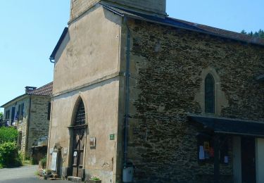
Magnifique circuit empruntant d'abord un petit parcours "Art et Nature" puis se développant à travers collines et campagne, le long de ruisseaux tumultueux. Un petit détour permet de passer par l'église ND de Verdale, accrochée le long de la falaise bordant le Tolerme.
Positioning
Country:
France
Region :
Occitania
Department/Province :
Lot
Municipality :
Latouille-Lentillac
Location:
Unknown
Start:(Dec)
Start:(UTM)
418136 ; 4967289 (31T) N.
Comments
Trails nearby
![Trail Walking Ladirat - vallée heureuse - Photo](https://media.geolcdn.com/t/375/260/c06784b0-0d78-47b8-aac1-f9b3521abf51.jpg&format=jpg&maxdim=2)
![Walking Walking](https://static1.geolcdn.com/sitytour/trail-icons/101.png)
vallée heureuse
Walking
Difficult
Ladirat,
Occitania,
Lot,
France
![](/images/other/stat-length.png)
12.8 km | 17.8 km-effort
3h 21min
![](https://static1.geolcdn.com/siteimages/upload/files/16400158638029165_repeat_loop_refresh_sync_direction_icon.png)
Yes
![Trail Walking Latouille-Lentillac - Arts nature 🏞 Latouille Lentillac - Photo](https://media.geolcdn.com/t/375/260/c159d4e3-bd24-4c47-aa99-b15a7786371b.jpg&format=jpg&maxdim=2)
![Walking Walking](https://static1.geolcdn.com/sitytour/trail-icons/101.png)
Arts nature 🏞 Latouille Lentillac
Walking
Very easy
Latouille-Lentillac,
Occitania,
Lot,
France
![](/images/other/stat-length.png)
1.9 km | 3 km-effort
1h 30min
![](https://static1.geolcdn.com/siteimages/upload/files/16400158638029165_repeat_loop_refresh_sync_direction_icon.png)
Yes
![Trail Car Saint-Laurent-les-Tours - 45 - Photo](https://media.geolcdn.com/t/375/260/ext.jpg?maxdim=2&url=https%3A%2F%2Fstatic1.geolcdn.com%2Fsiteimages%2Fupload%2Ffiles%2F15247431544x4.jpg)
![Car Car](https://static1.geolcdn.com/sitytour/trail-icons/401.png)
![Trail Walking Latouille-Lentillac - Les trois églises - Photo](https://media.geolcdn.com/t/375/260/ext.jpg?maxdim=2&url=https%3A%2F%2Fstatic1.geolcdn.com%2Fsiteimages%2Fupload%2Ffiles%2F1553511878bg_sport_marche.png)
![Walking Walking](https://static1.geolcdn.com/sitytour/trail-icons/101.png)
Les trois églises
Walking
Easy
Latouille-Lentillac,
Occitania,
Lot,
France
![](/images/other/stat-length.png)
13.5 km | 21 km-effort
3h 55min
![](https://static1.geolcdn.com/siteimages/upload/files/16400158638029165_repeat_loop_refresh_sync_direction_icon.png)
Yes
![Trail Cycle Saint-Laurent-les-Tours - Saint Laurent les tour - Photo](https://media.geolcdn.com/t/375/260/ext.jpg?maxdim=2&url=https%3A%2F%2Fstatic1.geolcdn.com%2Fsiteimages%2Fupload%2Ffiles%2F1524743154velo.jpg)
![Cycle Cycle](https://static1.geolcdn.com/sitytour/trail-icons/200.png)
Saint Laurent les tour
Cycle
Very easy
Saint-Laurent-les-Tours,
Occitania,
Lot,
France
![](/images/other/stat-length.png)
15.8 km | 17.6 km-effort
1h 2min
![](https://static1.geolcdn.com/siteimages/upload/files/16400158638029165_repeat_loop_refresh_sync_direction_icon.png)
No
![Trail Walking Latouille-Lentillac - La touille - Photo](https://media.geolcdn.com/t/375/260/ext.jpg?maxdim=2&url=https%3A%2F%2Fstatic1.geolcdn.com%2Fsiteimages%2Fupload%2Ffiles%2F1553511878bg_sport_marche.png)
![Walking Walking](https://static1.geolcdn.com/sitytour/trail-icons/101.png)
La touille
Walking
Difficult
Latouille-Lentillac,
Occitania,
Lot,
France
![](/images/other/stat-length.png)
12 km | 17.9 km-effort
3h 47min
![](https://static1.geolcdn.com/siteimages/upload/files/16400158638029165_repeat_loop_refresh_sync_direction_icon.png)
Yes
![Trail Walking Sousceyrac-en-Quercy - Autour de Lacamvieille - Photo](https://media.geolcdn.com/t/375/260/ext.jpg?maxdim=2&url=https%3A%2F%2Fstatic1.geolcdn.com%2Fsiteimages%2Fupload%2Ffiles%2F1553511878bg_sport_marche.png)
![Walking Walking](https://static1.geolcdn.com/sitytour/trail-icons/101.png)
Autour de Lacamvieille
Walking
Medium
Sousceyrac-en-Quercy,
Occitania,
Lot,
France
![](/images/other/stat-length.png)
9 km | 11.4 km-effort
2h 5min
![](https://static1.geolcdn.com/siteimages/upload/files/16400158638029165_repeat_loop_refresh_sync_direction_icon.png)
Yes