Trail Electric bike Nice - tour du sanctuaire de l'Aghet - Photo

tour du sanctuaire de l'Aghet

© OpenStreetMap contributors
Length
Length
33 km
Max alt
Max alt
694 m
Uphill gradient
Uphill gradient
1092 m
Km-Effort
Km-Effort  
47 km
Min alt
Min alt
26 m
Downhill gradient
Downhill gradient
1097 m
Boucle
Boucle
Yes
Creation date :
2022-01-15 10:01:39.137
Updated on :
2022-01-16 11:17:33.246

(0 Reviews)

Electric bike
Electric bike
2h55
Difficulty : Difficult

Scan this QR Code to open this trail in the SityTrail application

FREE GPS app for hiking

Logo SityTrail SityTrail

IGN / Geographical institutes

Download SityTrail from the App Store Download SityTrail from Google Play

Logo SityTrail SityTrail World

The world is yours!

Download SityTrail from the App Store Download SityTrail from Google Play Download SityTrail on Huawei AppGallery

About

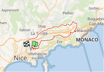
Trail Electric bike of 33 km to be discovered at Provence-Alpes-Côte d'Azur, Maritime Alps, Nice. This trail is proposed by djejenski.

Description

départ Nice st Roch, fort de la Révère, la turbie, Mt Bataille, col de guerre, Spraès, plateau tercié, la Trinité, retour st Roch.

Elevation profile

Photos

Positioning

Country:
France
Region :
Provence-Alpes-Côte d'Azur
Department/Province :
Maritime Alps
Municipality :
Nice
Location:
Unknown
Start:(UTM)
362541 ; 4841473 (32T) N.

Trails nearby

Trail Walking Nice - Ballade chemin des douaniers Nice-Villefranche  - Photo
Walking
coriace

Walking

Very easy
(1)
Nice, Provence-Alpes-Côte d'Azur, Maritime Alps, France
7.9 km | 10.3 km-effort
2h 13min
No
Trail Walking Nice - Collines niçoises - Photo
Walking
kenhava

Walking

Easy
(1)
Nice, Provence-Alpes-Côte d'Azur, Maritime Alps, France
21 km | 30 km-effort
6h 32min
No
Trail Walking Saint-Jean-Cap-Ferrat - Cap Ferrat 2011-10-27 - Photo
Walking
Cricounet84

Walking

Medium
(2)
Saint-Jean-Cap-Ferrat, Provence-Alpes-Côte d'Azur, Maritime Alps, France
10.9 km | 14 km-effort
4h 0min
Yes
Trail Walking Saint-Jean-Cap-Ferrat - Tour du Cap Ferrat - Photo
Walking
GUIDE
Orcal37

Walking

Easy
Saint-Jean-Cap-Ferrat, Provence-Alpes-Côte d'Azur, Maritime Alps, France
7.1 km | 9.4 km-effort
1h 40min
Yes
Trail Walking Saint-Jean-Cap-Ferrat - w-frankrijk-tour-du-cap-ferrat - Photo
Walking
gpstracks

Walking

Very easy
(1)
Saint-Jean-Cap-Ferrat, Provence-Alpes-Côte d'Azur, Maritime Alps, France
6.5 km | 8.6 km-effort
Unknown
No
Trail Walking Èze - eze 221213 - Photo
Walking
legios84

Walking

Medium
(1)
Èze, Provence-Alpes-Côte d'Azur, Maritime Alps, France
9.9 km | 14.7 km-effort
2h 4min
Yes
Trail Walking Saint-Jean-Cap-Ferrat - Tour du Cap Ferrat - Photo
Walking
tracegps

Walking

Medium
(4)
Saint-Jean-Cap-Ferrat, Provence-Alpes-Côte d'Azur, Maritime Alps, France
8.9 km | 11.2 km-effort
2h 0min
Yes
Trail Walking Nice - Nice  cathédrale Russe  - Photo
Walking
JEANJOSY

Walking

Very easy
Nice, Provence-Alpes-Côte d'Azur, Maritime Alps, France
6.9 km | 7.8 km-effort
2h 10min
Yes
Trail Walking Nice - Nice - Tour du Mont Boron - Photo
Walking
LightStalker

Walking

Easy
Nice, Provence-Alpes-Côte d'Azur, Maritime Alps, France
7.3 km | 10.5 km-effort
2h 48min
Yes


Close
My subscriptions