![](/images/other/stat-length.png)
![Trail Walking La Motte-d'Aveillans - Col du Sénépy et Pierre Plantée depuis les Signaraux - Photo](https://media.geolcdn.com/t/1900/400/cfea585a-9c0d-41ae-ace9-cab390a4faa0.jpg&format=pjpeg&maxdim=2)
Col du Sénépy et Pierre Plantée depuis les Signaraux
GuyVachet
User
![Length](/images/other/stat-length.png)
![Max alt](https://static1.geolcdn.com/siteimages/upload/files/1508320355ic_sort_altitude_max_24dp.png)
![Uphill gradient](https://static1.geolcdn.com/siteimages/upload/files/1508320355ic_sort_den_pos_24dp.png)
![Km-Effort](/images/other/stat-length.png)
![Min alt](https://static1.geolcdn.com/siteimages/upload/files/1508320355ic_sort_altitude_min_24dp.png)
![Downhill gradient](https://static1.geolcdn.com/siteimages/upload/files/1508320355ic_sort_den_neg_24dp.png)
![Boucle](https://static1.geolcdn.com/siteimages/upload/files/16400158638029165_repeat_loop_refresh_sync_direction_icon.png)
![Walking](https://static1.geolcdn.com/sitytour/trail-icons/101.png)
5h39
Difficulty : Medium
![Scan this QR Code to open this trail in the SityTrail application](https://capi.geolives.com/qq0zvz2zws4bq2lad0pu/sitytour/trails/3050467/qr.png?size=200)
FREE GPS app for hiking
About
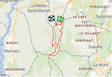
Trail Walking of 10.2 km to be discovered at Auvergne-Rhône-Alpes, Isère, La Motte-d'Aveillans. This trail is proposed by GuyVachet.
Description
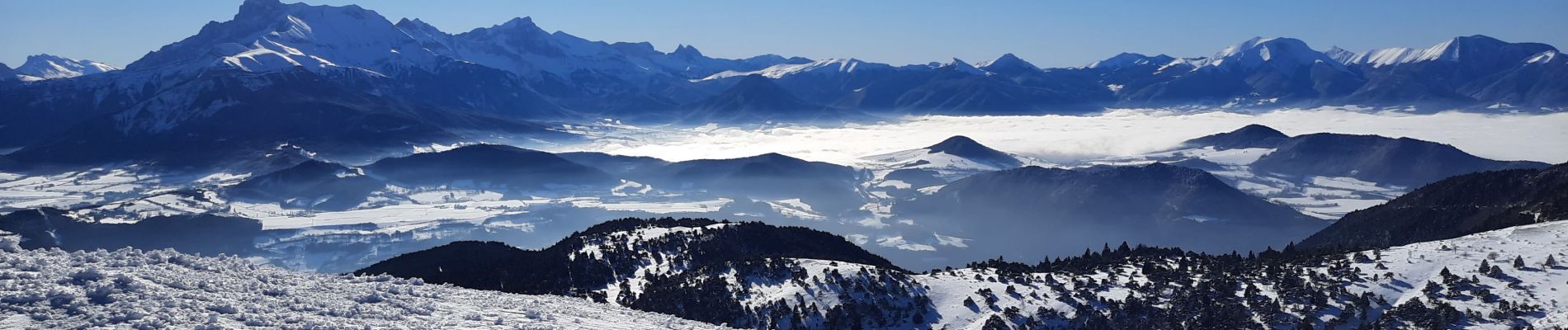
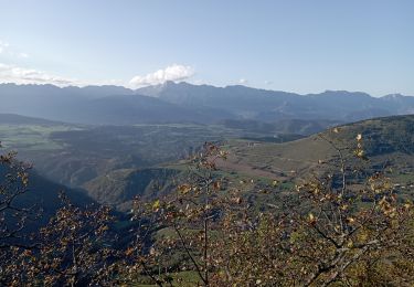
Belle boucle en raquettes sans risque particulier avec un superbe panorama sur les crêtes, panorama à 360° qui va du Vercors, la Chartreuse, le Taillefer et l'Alpe du Grand Serre, l'Oisans et le Dévoluy. Et qui plus est, nous avons eu de très bonnes conditions météo (soleil et très peu de vent) avec une bonne neige récente (soufflée sur les crêtes).
Positioning
Comments
Trails nearby
![Trail Road bike La Mure - La Mure les 4 lacs - Photo](https://media.geolcdn.com/t/375/260/ext.jpg?maxdim=2&url=https%3A%2F%2Fstatic1.geolcdn.com%2Fsiteimages%2Fupload%2Ffiles%2F1524743154velo.jpg)
![Road bike Road bike](https://static1.geolcdn.com/sitytour/trail-icons/201.png)
Road bike
![](/images/other/stat-length.png)
![](https://static1.geolcdn.com/siteimages/upload/files/16400158638029165_repeat_loop_refresh_sync_direction_icon.png)
![Walking Walking](https://static1.geolcdn.com/sitytour/trail-icons/101.png)
Walking
![](/images/other/stat-length.png)
![](https://static1.geolcdn.com/siteimages/upload/files/16400158638029165_repeat_loop_refresh_sync_direction_icon.png)
![Trail Mountain bike Pierre-Châtel - Tour des lacs Pierre-Chatel - Photo](https://media.geolcdn.com/t/375/260/ext.jpg?maxdim=2&url=https%3A%2F%2Fstatic1.geolcdn.com%2Fsiteimages%2Fupload%2Ffiles%2F1524743154velo.jpg)
![Mountain bike Mountain bike](https://static1.geolcdn.com/sitytour/trail-icons/202.png)
Mountain bike
![](/images/other/stat-length.png)
![](https://static1.geolcdn.com/siteimages/upload/files/16400158638029165_repeat_loop_refresh_sync_direction_icon.png)
![Trail Walking La Motte-Saint-Martin - connex en boucle - Photo](https://media.geolcdn.com/t/375/260/a85b9cb7-206d-4f86-ae8b-a6cb3e334179.jpg&format=jpg&maxdim=2)
![Walking Walking](https://static1.geolcdn.com/sitytour/trail-icons/101.png)
Walking
![](/images/other/stat-length.png)
![](https://static1.geolcdn.com/siteimages/upload/files/16400158638029165_repeat_loop_refresh_sync_direction_icon.png)
![Trail Walking La Motte-d'Aveillans - petite balade - Photo](https://media.geolcdn.com/t/375/260/c8ab192f-feb7-4747-af86-e7381ac953ed.jpg&format=jpg&maxdim=2)
![Walking Walking](https://static1.geolcdn.com/sitytour/trail-icons/101.png)
Walking
![](/images/other/stat-length.png)
![](https://static1.geolcdn.com/siteimages/upload/files/16400158638029165_repeat_loop_refresh_sync_direction_icon.png)
![Trail Walking La Motte-Saint-Martin - connex - Photo](https://media.geolcdn.com/t/375/260/874cc892-61da-4872-9785-f7893aa41f95.jpg&format=jpg&maxdim=2)
![Walking Walking](https://static1.geolcdn.com/sitytour/trail-icons/101.png)
Walking
![](/images/other/stat-length.png)
![](https://static1.geolcdn.com/siteimages/upload/files/16400158638029165_repeat_loop_refresh_sync_direction_icon.png)
![Trail Walking Susville - Susville les Merlins boucle par le col du Sénépiy - Photo](https://media.geolcdn.com/t/375/260/e34bcbf0-51cf-49b5-a532-234a88d268fc.jpg&format=jpg&maxdim=2)
![Walking Walking](https://static1.geolcdn.com/sitytour/trail-icons/101.png)
Walking
![](/images/other/stat-length.png)
![](https://static1.geolcdn.com/siteimages/upload/files/16400158638029165_repeat_loop_refresh_sync_direction_icon.png)
![Trail Walking La Motte-Saint-Martin - Sinepi - Photo](https://media.geolcdn.com/t/375/260/ext.jpg?maxdim=2&url=https%3A%2F%2Fstatic1.geolcdn.com%2Fsiteimages%2Fupload%2Ffiles%2F1553511878bg_sport_marche.png)
![Walking Walking](https://static1.geolcdn.com/sitytour/trail-icons/101.png)
Walking
![](/images/other/stat-length.png)
![](https://static1.geolcdn.com/siteimages/upload/files/16400158638029165_repeat_loop_refresh_sync_direction_icon.png)
![Trail Mountain bike La Motte-d'Aveillans - Le Sénépy depuis Les Signaraux - Photo](https://media.geolcdn.com/t/375/260/48b7fa7e-1a2a-4b01-b381-61d2b963f1f0.jpg&format=jpg&maxdim=2)
![Mountain bike Mountain bike](https://static1.geolcdn.com/sitytour/trail-icons/202.png)
Mountain bike
![](/images/other/stat-length.png)
![](https://static1.geolcdn.com/siteimages/upload/files/16400158638029165_repeat_loop_refresh_sync_direction_icon.png)