Trail On foot Wingles - WINGLES 13km - Photo
 fif59280
fif59280

User

© OpenStreetMap contributors
Length
Length
13 km
Max alt
Max alt
32 m
Uphill gradient
Uphill gradient
83 m
Km-Effort
Km-Effort  
14.1 km
Min alt
Min alt
17 m
Downhill gradient
Downhill gradient
81 m
Boucle
Boucle
Yes
Creation date :
2022-01-10 17:22:57.631
Updated on :
2022-01-10 17:34:28.665

(0 Reviews)

On foot
On foot
3h11
Difficulty : Easy

Scan this QR Code to open this trail in the SityTrail application

FREE GPS app for hiking

Logo SityTrail SityTrail

IGN / Geographical institutes

Download SityTrail from the App Store Download SityTrail from Google Play

Logo SityTrail SityTrail World

The world is yours!

Download SityTrail from the App Store Download SityTrail from Google Play Download SityTrail on Huawei AppGallery

About

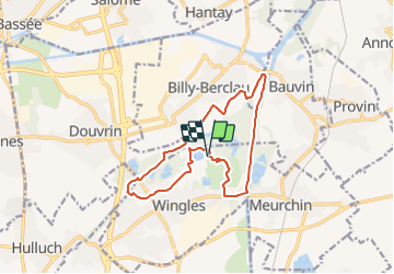
Trail On foot of 13 km to be discovered at Hauts-de-France, Pas-de-Calais, Wingles. This trail is proposed by fif59280.

Description

De la base de loisir (étang Marcel, rue René CLAIR), faire le tour de l'étang et rejoindre l'arrière du cimetière. Puis, tout droit traverser un peu de ville jusqu'à passer sous un pont SNCF sur votre gauche (attention aucun trottoir). Puis tout de suite à droite, rentrer dans la partie verte en restant sur la partie à votre droite jusqu'à la route. Suivez la à droite sur 30 m puis à gauche suivez le GRP. Au bout à gauche, puis à droite suivez le chemin empierré. Rejoignez l'antenne téléphonique et après 50m virer à gauche pour suivre le PR. Rejoindre la DEULE et la descendre jusqu'au pont (virer à droite 20m avant). aller jusqu'au pont SNCF et virer à droite juste avant. Prendre un chemin à droite après l'habitation pour rejoindre le point de départ par les bois. Vous avez plusieurs alternatives pour allonger ou réduire le kilométrage, tout au long du parcours (voir autres randos).

Elevation profile

Positioning

Country:
France
Region :
Hauts-de-France
Department/Province :
Pas-de-Calais
Municipality :
Wingles
Location:
Unknown
Start:(UTM)
490580 ; 5594792 (31U) N.

Trails nearby

Trail Hybrid bike Wingles - Wingles parc de la souchez - Photo
Hybrid bike
yves62410

Hybrid bike

(1)
Wingles, Hauts-de-France, Pas-de-Calais, France
34 km | 36 km-effort
1h 53min
Yes
Trail Walking La Bassée - La Basée 13 km - Photo
Walking
GUIDE
rvapeldo

Walking

Easy
La Bassée, Hauts-de-France, Nord, France
13 km | 13.7 km-effort
3h 26min
Yes
Trail Walking Bauvin - Wingles - Photo
Walking
sandrine brisset

Walking

Medium
Bauvin, Hauts-de-France, Nord, France
11.8 km | 13 km-effort
3h 25min
No
Trail Electric bike Wingles - Wingles BÈthune vimy - Photo
Electric bike
yves62410

Electric bike

Medium
Wingles, Hauts-de-France, Pas-de-Calais, France
82 km | 92 km-effort
5h 32min
Yes
Trail Walking Haisnes - La gare - Haisnes - Photo
Walking
tracegps

Walking

Medium
Haisnes, Hauts-de-France, Pas-de-Calais, France
10.1 km | 10.8 km-effort
2h 30min
Yes
Trail Walking Billy-Berclau - Le chemin vert - Billy-Berclau - Photo
Walking
tracegps

Walking

Medium
Billy-Berclau, Hauts-de-France, Pas-de-Calais, France
9.2 km | 9.7 km-effort
2h 15min
Yes
Trail Cycle Wingles - Les parcs - Wingles - Photo
Cycle
tracegps

Cycle

Easy
(1)
Wingles, Hauts-de-France, Pas-de-Calais, France
29 km | 31 km-effort
2h 0min
Yes
Trail Walking Hantay - Circuit découverte nature des Weppes - Hantay - Photo
Walking
tracegps

Walking

Medium
(2)
Hantay, Hauts-de-France, Nord, France
9.2 km | 9.8 km-effort
2h 19min
Yes
Trail Electric bike Wingles - Vers Lorette  - Photo
Electric bike
yves62410

Electric bike

Easy
Wingles, Hauts-de-France, Pas-de-Calais, France
50 km | 55 km-effort
2h 49min
Yes


Close
My subscriptions