![](/images/other/stat-length.png)
![Trail Walking École - Bauges 2021 : le Carlet - Chalets d'Orgeval.ori - Photo](https://media.geolcdn.com/t/1900/400/fbf915b9-458b-472f-98f2-22e01353467c.jpg&format=pjpeg&maxdim=2)
Bauges 2021 : le Carlet - Chalets d'Orgeval.ori
PatDev
User
![Length](/images/other/stat-length.png)
Length
18.6 km
![Max alt](https://static1.geolcdn.com/siteimages/upload/files/1508320355ic_sort_altitude_max_24dp.png)
Max alt
1609 m
![Uphill gradient](https://static1.geolcdn.com/siteimages/upload/files/1508320355ic_sort_den_pos_24dp.png)
Uphill gradient
914 m
![Km-Effort](/images/other/stat-length.png)
Km-Effort
31 km
![Min alt](https://static1.geolcdn.com/siteimages/upload/files/1508320355ic_sort_altitude_min_24dp.png)
Min alt
810 m
![Downhill gradient](https://static1.geolcdn.com/siteimages/upload/files/1508320355ic_sort_den_neg_24dp.png)
Downhill gradient
921 m
![Boucle](https://static1.geolcdn.com/siteimages/upload/files/16400158638029165_repeat_loop_refresh_sync_direction_icon.png)
Boucle
Yes
Creation date :
2021-12-23 08:23:30.549
Updated on :
2022-07-20 18:53:03.34
![Walking](https://static1.geolcdn.com/sitytour/trail-icons/101.png)
5h00
Difficulty : Easy
![Trail](https://static1.geolcdn.com/sitytour/trail-icons/104.png)
4h00
Difficulty : Medium
![Snowshoes](https://static1.geolcdn.com/sitytour/trail-icons/504.png)
7h00
Difficulty : Medium
![Scan this QR Code to open this trail in the SityTrail application](https://capi.geolives.com/qq0zvz2zws4bq2lad0pu/sitytour/trails/3047063/qr.png?size=200)
FREE GPS app for hiking
About
Trail Walking of 18.6 km to be discovered at Auvergne-Rhône-Alpes, Savoy, École. This trail is proposed by PatDev.
Description
Belle randonnée dans la neige avec de magnifiques tapis cristallisés.
Dans l'ombre une bonne partie de la montée puis au soleil pour le déjeuner.
Progression en raquette en partie sur de la neige vierge est magnifique mais éprouvante.
Positioning
Country:
France
Region :
Auvergne-Rhône-Alpes
Department/Province :
Savoy
Municipality :
École
Location:
Unknown
Start:(Dec)
Start:(UTM)
281198 ; 5057710 (32T) N.
Comments
Trails nearby
![Trail Walking Jarsy - BAUGES: PRECHEREL - CROIX D'ALLANT - PLAN DE LA LIMACE - en direction du Mont de la Coche - Photo](https://media.geolcdn.com/t/375/260/a1c1a220-f26a-4fbe-a6ad-eda1f1982f07.jpg&format=jpg&maxdim=2)
![Walking Walking](https://static1.geolcdn.com/sitytour/trail-icons/101.png)
BAUGES: PRECHEREL - CROIX D'ALLANT - PLAN DE LA LIMACE - en direction du Mont...
Walking
Difficult
(1)
Jarsy,
Auvergne-Rhône-Alpes,
Savoy,
France
![](/images/other/stat-length.png)
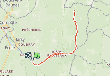
13.1 km | 24 km-effort
4h 45min
![](https://static1.geolcdn.com/siteimages/upload/files/16400158638029165_repeat_loop_refresh_sync_direction_icon.png)
Yes
![Trail Walking Doucy-en-Bauges - Traversée du Mont Trélod, 2181m - Photo](https://media.geolcdn.com/t/375/260/ext.jpg?maxdim=2&url=https%3A%2F%2Fservices.sitytrail.com%2FGeolivesWS%2FDownloadMedia.ashx%3FTrailID%3D103833%26Media%3D6623_1.jpg)
![Walking Walking](https://static1.geolcdn.com/sitytour/trail-icons/101.png)
Traversée du Mont Trélod, 2181m
Walking
Medium
(1)
Doucy-en-Bauges,
Auvergne-Rhône-Alpes,
Savoy,
France
![](/images/other/stat-length.png)
10.9 km | 28 km-effort
7h 30min
![](https://static1.geolcdn.com/siteimages/upload/files/16400158638029165_repeat_loop_refresh_sync_direction_icon.png)
No
![Trail Walking Jarsy - parc à moutons - Photo](https://media.geolcdn.com/t/375/260/11b94c96-e376-4153-b4eb-464e23c1ffc4.jpg&format=jpg&maxdim=2)
![Walking Walking](https://static1.geolcdn.com/sitytour/trail-icons/101.png)
parc à moutons
Walking
Medium
Jarsy,
Auvergne-Rhône-Alpes,
Savoy,
France
![](/images/other/stat-length.png)
11.3 km | 25 km-effort
6h 0min
![](https://static1.geolcdn.com/siteimages/upload/files/16400158638029165_repeat_loop_refresh_sync_direction_icon.png)
No
![Trail Walking Aillon-le-Jeune - Bauges le Colombier et des crêtes - Photo](https://media.geolcdn.com/t/375/260/ext.jpg?maxdim=2&url=https%3A%2F%2Fstatic1.geolcdn.com%2Fsiteimages%2Fupload%2Ffiles%2F1553511878bg_sport_marche.png)
![Walking Walking](https://static1.geolcdn.com/sitytour/trail-icons/101.png)
Bauges le Colombier et des crêtes
Walking
Medium
(1)
Aillon-le-Jeune,
Auvergne-Rhône-Alpes,
Savoy,
France
![](/images/other/stat-length.png)
14.2 km | 28 km-effort
5h 35min
![](https://static1.geolcdn.com/siteimages/upload/files/16400158638029165_repeat_loop_refresh_sync_direction_icon.png)
Yes
![Trail Walking Le Châtelard - Roc poyet - Photo](https://media.geolcdn.com/t/375/260/a503fd55-09ac-42bc-9003-547472a05706.jpg&format=jpg&maxdim=2)
![Walking Walking](https://static1.geolcdn.com/sitytour/trail-icons/101.png)
Roc poyet
Walking
Medium
Le Châtelard,
Auvergne-Rhône-Alpes,
Savoy,
France
![](/images/other/stat-length.png)
8.2 km | 19.8 km-effort
5h 6min
![](https://static1.geolcdn.com/siteimages/upload/files/16400158638029165_repeat_loop_refresh_sync_direction_icon.png)
Yes
![Trail Walking École - Dent et col d'Arclusaz par le col de la cochette - Photo](https://media.geolcdn.com/t/375/260/feaa7030-038c-4a29-b681-d1c2b1a0e6a1.jpg&format=jpg&maxdim=2)
![Walking Walking](https://static1.geolcdn.com/sitytour/trail-icons/101.png)
Dent et col d'Arclusaz par le col de la cochette
Walking
Difficult
École,
Auvergne-Rhône-Alpes,
Savoy,
France
![](/images/other/stat-length.png)
15.9 km | 33 km-effort
6h 18min
![](https://static1.geolcdn.com/siteimages/upload/files/16400158638029165_repeat_loop_refresh_sync_direction_icon.png)
Yes
![Trail Walking Jarsy - col orgeval - Photo](https://media.geolcdn.com/t/375/260/ext.jpg?maxdim=2&url=https%3A%2F%2Fstatic1.geolcdn.com%2Fsiteimages%2Fupload%2Ffiles%2F1553511878bg_sport_marche.png)
![Walking Walking](https://static1.geolcdn.com/sitytour/trail-icons/101.png)
col orgeval
Walking
Easy
(1)
Jarsy,
Auvergne-Rhône-Alpes,
Savoy,
France
![](/images/other/stat-length.png)
11.9 km | 22 km-effort
Unknown
![](https://static1.geolcdn.com/siteimages/upload/files/16400158638029165_repeat_loop_refresh_sync_direction_icon.png)
Yes
![Trail Walking Jarsy - nôtre dame de Bellevaux - Photo](https://media.geolcdn.com/t/375/260/1be31ea5-d3d1-459b-88d3-6aa2e29612aa.jpg&format=jpg&maxdim=2)
![Walking Walking](https://static1.geolcdn.com/sitytour/trail-icons/101.png)
nôtre dame de Bellevaux
Walking
Very easy
Jarsy,
Auvergne-Rhône-Alpes,
Savoy,
France
![](/images/other/stat-length.png)
5.2 km | 7.9 km-effort
1h 28min
![](https://static1.geolcdn.com/siteimages/upload/files/16400158638029165_repeat_loop_refresh_sync_direction_icon.png)
Yes
![Walking Walking](https://static1.geolcdn.com/sitytour/trail-icons/101.png)
Croix d'Allant et Plan de la Limace
Walking
Very difficult
Jarsy,
Auvergne-Rhône-Alpes,
Savoy,
France
![](/images/other/stat-length.png)
14.6 km | 26 km-effort
6h 29min
![](https://static1.geolcdn.com/siteimages/upload/files/16400158638029165_repeat_loop_refresh_sync_direction_icon.png)
Yes