![](/images/other/stat-length.png)
![Trail Walking Nandrin - Promenade de la Rochette - Photo](https://media.geolcdn.com/t/1900/400/5a74fe2d-3165-4a5e-bca4-cf4887f2281c.jpg&format=pjpeg&maxdim=2)
Promenade de la Rochette
Au fil de nos découvertes
« L’heure de la fin des découvertes ne sonne jamais. » Colette GUIDE+
![Length](/images/other/stat-length.png)
![Max alt](https://static1.geolcdn.com/siteimages/upload/files/1508320355ic_sort_altitude_max_24dp.png)
![Uphill gradient](https://static1.geolcdn.com/siteimages/upload/files/1508320355ic_sort_den_pos_24dp.png)
![Km-Effort](/images/other/stat-length.png)
![Min alt](https://static1.geolcdn.com/siteimages/upload/files/1508320355ic_sort_altitude_min_24dp.png)
![Downhill gradient](https://static1.geolcdn.com/siteimages/upload/files/1508320355ic_sort_den_neg_24dp.png)
![Boucle](https://static1.geolcdn.com/siteimages/upload/files/16400158638029165_repeat_loop_refresh_sync_direction_icon.png)
![Walking](https://static1.geolcdn.com/sitytour/trail-icons/101.png)
2h54
Difficulty : Difficult
![Scan this QR Code to open this trail in the SityTrail application](https://capi.geolives.com/qq0zvz2zws4bq2lad0pu/sitytour/trails/3046561/qr.png?size=200)
FREE GPS app for hiking
About
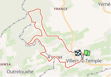
Trail Walking of 9.6 km to be discovered at Wallonia, Liège, Nandrin. This trail is proposed by Au fil de nos découvertes.
Description
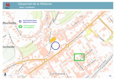
🅿️ Départ et Parking:
Eglise Saint-Pierre
Rue de la tourette
4550 Nandrin
▶️ Suivre la balise « rectangle rouge »
Le balisage n’étant pas bon. Dans un sens comme dans l’autre.
Le départ se fait dans le joli village de Villers-le
-Temple, vous traverserez les campagnes, mais également une forêt domaniale.
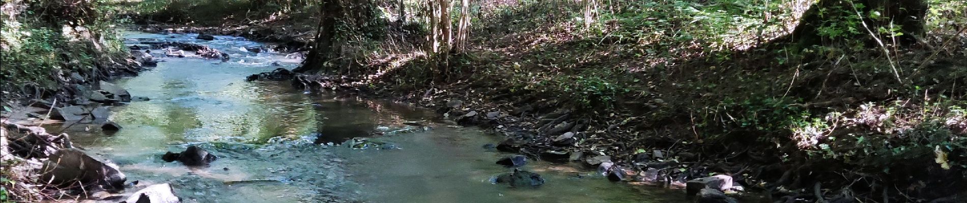
Vous longerez le ruisseau d’Oxne pour remonter vers la Rochette. (Roche constituée de poudingue – agglomération de galets à l’aspect de béton)
Possibilités de pique-niquer. 🥪🍴
Chiens autorisés en laisse. 🐩🐶🐕
Convient pour les enfants . 👱👱♂️
Ne convient pas pour les poussettes et personnes à mobilité réduite. 👨🦽👩🦽👶
N'hésitez pas à aller faire un tour sur notre site internet et nos réseaux :
www.aufildenosdecouvertes.com
www.facebook.com/aufildenosdecouvertes
https://www.instagram.com/au_fil_de_nos_decouvertes/
Positioning
Comments
Trails nearby
![Trail Walking Modave - Rausa GR 575 bis - Photo](https://media.geolcdn.com/t/375/260/ext.jpg?maxdim=2&url=https%3A%2F%2Fstatic1.geolcdn.com%2Fsiteimages%2Fupload%2Ffiles%2F1553511878bg_sport_marche.png)
![Walking Walking](https://static1.geolcdn.com/sitytour/trail-icons/101.png)
Walking
![](/images/other/stat-length.png)
![](https://static1.geolcdn.com/siteimages/upload/files/16400158638029165_repeat_loop_refresh_sync_direction_icon.png)
![Trail Walking Nandrin - Villers le temple . st jean sart . clemaude - Photo](https://media.geolcdn.com/t/375/260/c7438fda-ad3c-4a12-91ed-f3aabfc6b7ce.jpg&format=jpg&maxdim=2)
![Walking Walking](https://static1.geolcdn.com/sitytour/trail-icons/101.png)
Walking
![](/images/other/stat-length.png)
![](https://static1.geolcdn.com/siteimages/upload/files/16400158638029165_repeat_loop_refresh_sync_direction_icon.png)
![Trail Walking Modave - MODAVE - Froide Fontaine - Photo](https://media.geolcdn.com/t/375/260/ext.jpg?maxdim=2&url=https%3A%2F%2Fservices.sitytrail.com%2FGeolivesWS%2FDownloadMedia.ashx%3FTrailID%3D163540%26Media%3Da9dfd4e0-07be-4695-be31-23a02d75fa1f.jpg)
![Walking Walking](https://static1.geolcdn.com/sitytour/trail-icons/101.png)
Walking
![](/images/other/stat-length.png)
![](https://static1.geolcdn.com/siteimages/upload/files/16400158638029165_repeat_loop_refresh_sync_direction_icon.png)
![Trail Mountain bike Amay - casse gueul - Photo](https://media.geolcdn.com/t/375/260/ext.jpg?maxdim=2&url=https%3A%2F%2Fservices.sitytrail.com%2FGeolivesWS%2FDownloadMedia.ashx%3FTrailID%3D285464%26Media%3Dfix__20140511121633.jpg)
![Mountain bike Mountain bike](https://static1.geolcdn.com/sitytour/trail-icons/202.png)
Mountain bike
![](/images/other/stat-length.png)
![](https://static1.geolcdn.com/siteimages/upload/files/16400158638029165_repeat_loop_refresh_sync_direction_icon.png)
![Trail Walking Nandrin - promenade de la rochette : villers le temple - grand fond d'oxhe - villers le temple - Photo](https://media.geolcdn.com/t/375/260/6a65eaf0-07ca-4e09-ab79-c1ffba2fba6b.jpg&format=jpg&maxdim=2)
![Walking Walking](https://static1.geolcdn.com/sitytour/trail-icons/101.png)
Walking
![](/images/other/stat-length.png)
![](https://static1.geolcdn.com/siteimages/upload/files/16400158638029165_repeat_loop_refresh_sync_direction_icon.png)
![Trail Walking Modave - Stree reco 21 12 - Photo](https://media.geolcdn.com/t/375/260/ext.jpg?maxdim=2&url=https%3A%2F%2Fstatic1.geolcdn.com%2Fsiteimages%2Fupload%2Ffiles%2F1553511878bg_sport_marche.png)
![Walking Walking](https://static1.geolcdn.com/sitytour/trail-icons/101.png)
Walking
![](/images/other/stat-length.png)
![](https://static1.geolcdn.com/siteimages/upload/files/16400158638029165_repeat_loop_refresh_sync_direction_icon.png)
![Trail Walking Amay - 20230726 - TOTEMUS Amay - 6.1 Km - Photo](https://media.geolcdn.com/t/375/260/4112cd7d-32fc-4690-94e7-6dc07eacc03d.jpeg&format=jpg&maxdim=2)
![Walking Walking](https://static1.geolcdn.com/sitytour/trail-icons/101.png)
Walking
![](/images/other/stat-length.png)
![](https://static1.geolcdn.com/siteimages/upload/files/16400158638029165_repeat_loop_refresh_sync_direction_icon.png)
![Trail On foot Amay - Promenade d'Ombret - Photo](https://media.geolcdn.com/t/375/260/bbfa7314-541b-4540-af6f-869e2bd08b94.jpeg&format=jpg&maxdim=2)
![On foot On foot](https://static1.geolcdn.com/sitytour/trail-icons/100.png)
![Trail Walking Nandrin - Balade des bois de Yernée - Photo](https://media.geolcdn.com/t/375/260/ext.jpg?maxdim=2&url=https%3A%2F%2Fstatic1.geolcdn.com%2Fsiteimages%2Fupload%2Ffiles%2F1553511878bg_sport_marche.png)
![Walking Walking](https://static1.geolcdn.com/sitytour/trail-icons/101.png)
Walking
![](/images/other/stat-length.png)
![](https://static1.geolcdn.com/siteimages/upload/files/16400158638029165_repeat_loop_refresh_sync_direction_icon.png)