![](/images/other/stat-length.png)
![Trail Walking Châteauneuf-Villevieille - SityTrail - 3043294 - chateauneuf-villevieillex-barre-de-lendrex-la-grau - Photo](https://media.geolcdn.com/t/1900/400/ext.pjpeg?maxdim=2&url=https%3A%2F%2Fstatic1.geolcdn.com%2Fsiteimages%2Fupload%2Ffiles%2F1553511878bg_sport_marche.png)
SityTrail - 3043294 - chateauneuf-villevieillex-barre-de-lendrex-la-grau
clarambre
User
![Length](/images/other/stat-length.png)
![Max alt](https://static1.geolcdn.com/siteimages/upload/files/1508320355ic_sort_altitude_max_24dp.png)
![Uphill gradient](https://static1.geolcdn.com/siteimages/upload/files/1508320355ic_sort_den_pos_24dp.png)
![Km-Effort](/images/other/stat-length.png)
![Min alt](https://static1.geolcdn.com/siteimages/upload/files/1508320355ic_sort_altitude_min_24dp.png)
![Downhill gradient](https://static1.geolcdn.com/siteimages/upload/files/1508320355ic_sort_den_neg_24dp.png)
![Boucle](https://static1.geolcdn.com/siteimages/upload/files/16400158638029165_repeat_loop_refresh_sync_direction_icon.png)
![Walking](https://static1.geolcdn.com/sitytour/trail-icons/101.png)
4h04
Difficulty : Medium
![Scan this QR Code to open this trail in the SityTrail application](https://capi.geolives.com/qq0zvz2zws4bq2lad0pu/sitytour/trails/3044725/qr.png?size=200)
FREE GPS app for hiking
About
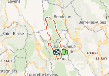
Trail Walking of 11.2 km to be discovered at Provence-Alpes-Côte d'Azur, Maritime Alps, Châteauneuf-Villevieille. This trail is proposed by clarambre.
Description
Boucle de 11 km, au départ du Col de Chateauneuf Villevieille
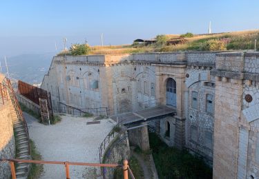
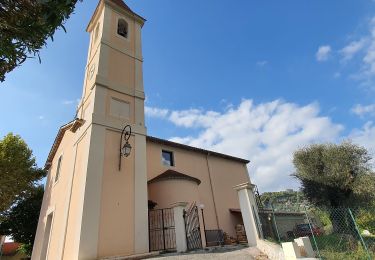
On descend au village, (visite de l'église, à la période de Noel, une très belle crèche, autrement les vitraux sont beaux) puis on remonte
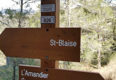
Hors chemins, suivre les pistes des trails 5 / 6 et 4
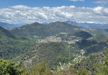
360 ° Pose déjeuner, puis redescendre en ayant la vue sur la mer et la ville de nice
Positioning
Comments
Trails nearby
![Trail Walking Aspremont - Aspremont tour du Mont Chauve, montée au fort. - Photo](https://media.geolcdn.com/t/375/260/16e89ccd-b354-4ef1-b144-0fc157d8768e.jpg&format=jpg&maxdim=2)
![Walking Walking](https://static1.geolcdn.com/sitytour/trail-icons/101.png)
Walking
![](/images/other/stat-length.png)
![](https://static1.geolcdn.com/siteimages/upload/files/16400158638029165_repeat_loop_refresh_sync_direction_icon.png)
![Trail Walking Cantaron - Cantaron : Monts Macaron et Ubac par Levens Tourette réelle - Photo](https://media.geolcdn.com/t/375/260/60da6868-ad90-4803-993b-f92b5b64ec1d.jpg&format=jpg&maxdim=2)
![Walking Walking](https://static1.geolcdn.com/sitytour/trail-icons/101.png)
Walking
![](/images/other/stat-length.png)
![](https://static1.geolcdn.com/siteimages/upload/files/16400158638029165_repeat_loop_refresh_sync_direction_icon.png)
![Trail Running Aspremont - Tour des Monts d'Aspremont 2007 - Photo](https://media.geolcdn.com/t/375/260/ext.jpg?maxdim=2&url=https%3A%2F%2Fstatic1.geolcdn.com%2Fsiteimages%2Fupload%2Ffiles%2F1524743154running.jpg)
![Running Running](https://static1.geolcdn.com/sitytour/trail-icons/103.png)
Running
![](/images/other/stat-length.png)
![](https://static1.geolcdn.com/siteimages/upload/files/16400158638029165_repeat_loop_refresh_sync_direction_icon.png)
![Trail Walking Cantaron - Cantaron : Monts Macaron et Ubac - Photo](https://media.geolcdn.com/t/375/260/0c099172-d426-4bc6-b370-544c7fbae01b.jpg&format=jpg&maxdim=2)
![Walking Walking](https://static1.geolcdn.com/sitytour/trail-icons/101.png)
Walking
![](/images/other/stat-length.png)
![](https://static1.geolcdn.com/siteimages/upload/files/16400158638029165_repeat_loop_refresh_sync_direction_icon.png)
![Trail Walking L'Escarène - L’Escarene - Photo](https://media.geolcdn.com/t/375/260/471a6d65-ba9a-4a94-ae56-e041c5f1c486.jpg&format=jpg&maxdim=2)
![Walking Walking](https://static1.geolcdn.com/sitytour/trail-icons/101.png)
Walking
![](/images/other/stat-length.png)
![](https://static1.geolcdn.com/siteimages/upload/files/16400158638029165_repeat_loop_refresh_sync_direction_icon.png)
![Trail Walking Tourrette-Levens - Tour Sud de Tourette Levens - Photo](https://media.geolcdn.com/t/375/260/e02c7a38-2f96-467c-9689-2a7fe0ea0b11.jpg&format=jpg&maxdim=2)
![Walking Walking](https://static1.geolcdn.com/sitytour/trail-icons/101.png)
Walking
![](/images/other/stat-length.png)
![](https://static1.geolcdn.com/siteimages/upload/files/16400158638029165_repeat_loop_refresh_sync_direction_icon.png)
![Walking Walking](https://static1.geolcdn.com/sitytour/trail-icons/101.png)
Walking
![](/images/other/stat-length.png)
![](https://static1.geolcdn.com/siteimages/upload/files/16400158638029165_repeat_loop_refresh_sync_direction_icon.png)
![Trail Walking Saint-Blaise - st Blaise - Photo](https://media.geolcdn.com/t/375/260/375b4df8-c870-4d3e-b07c-75a372f1a0f5.jpg&format=jpg&maxdim=2)
![Walking Walking](https://static1.geolcdn.com/sitytour/trail-icons/101.png)
Walking
![](/images/other/stat-length.png)
![](https://static1.geolcdn.com/siteimages/upload/files/16400158638029165_repeat_loop_refresh_sync_direction_icon.png)
![Trail Walking Saint-Blaise - St Blaise - Mont Inarte - Mont Cima - Photo](https://media.geolcdn.com/t/375/260/50248ffd-1584-454b-8993-746e69228911.jpg&format=jpg&maxdim=2)
![Walking Walking](https://static1.geolcdn.com/sitytour/trail-icons/101.png)
Walking
![](/images/other/stat-length.png)
![](https://static1.geolcdn.com/siteimages/upload/files/16400158638029165_repeat_loop_refresh_sync_direction_icon.png)