![](/images/other/stat-length.png)
![Trail Walking Watermael-Boitsfort - Watermaal-Bosvoorde - La forêt de Soignes par les GRs - Photo](https://media.geolcdn.com/t/1900/400/4b3c7aff-1830-4a19-b2a5-12d22b31284a.jpeg&format=pjpeg&maxdim=2)
La forêt de Soignes par les GRs
dauzata
User
![Length](/images/other/stat-length.png)
Length
21 km
![Max alt](https://static1.geolcdn.com/siteimages/upload/files/1508320355ic_sort_altitude_max_24dp.png)
Max alt
144 m
![Uphill gradient](https://static1.geolcdn.com/siteimages/upload/files/1508320355ic_sort_den_pos_24dp.png)
Uphill gradient
308 m
![Km-Effort](/images/other/stat-length.png)
Km-Effort
25 km
![Min alt](https://static1.geolcdn.com/siteimages/upload/files/1508320355ic_sort_altitude_min_24dp.png)
Min alt
52 m
![Downhill gradient](https://static1.geolcdn.com/siteimages/upload/files/1508320355ic_sort_den_neg_24dp.png)
Downhill gradient
305 m
![Boucle](https://static1.geolcdn.com/siteimages/upload/files/16400158638029165_repeat_loop_refresh_sync_direction_icon.png)
Boucle
Yes
Creation date :
2022-01-07 08:20:05.0
Updated on :
2022-01-07 15:22:22.758
![Walking](https://static1.geolcdn.com/sitytour/trail-icons/101.png)
4h12
Difficulty : Easy
![Scan this QR Code to open this trail in the SityTrail application](https://capi.geolives.com/qq0zvz2zws4bq2lad0pu/sitytour/trails/3044087/qr.png?size=200)
FREE GPS app for hiking
About
Trail Walking of 21 km to be discovered at Brussels-Capital, Unknown, Watermael-Boitsfort - Watermaal-Bosvoorde. This trail is proposed by dauzata.
Description
Départ: Restaurant "Au bon repos des chasseurs"
Départ alternatif: station métro Hermann-Debroux
Suivre le GR579, puis le GR512, et enfin le GR126.
Positioning
Country:
Belgium
Region :
Brussels-Capital
Department/Province :
Unknown
Municipality :
Watermael-Boitsfort - Watermaal-Bosvoorde
Location:
Unknown
Start:(Dec)
Start:(UTM)
600853 ; 5628825 (31U) N.
Comments
Trails nearby
![Trail Walking Hoeilaart - GG-Bw-04_Hoeilaart - Genval - Photo](https://media.geolcdn.com/t/375/260/364592d0-bbf8-45ce-9ea9-708b8ca7581f.jpg&format=jpg&maxdim=2)
![Walking Walking](https://static1.geolcdn.com/sitytour/trail-icons/101.png)
GG-Bw-04_Hoeilaart - Genval
Walking
Very difficult
(6)
Hoeilaart,
Flanders,
Flemish Brabant,
Belgium
![](/images/other/stat-length.png)
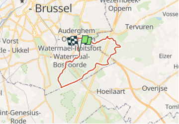
23 km | 28 km-effort
5h 54min
![](https://static1.geolcdn.com/siteimages/upload/files/16400158638029165_repeat_loop_refresh_sync_direction_icon.png)
No
![Trail Walking Auderghem - Oudergem - RB-BXL-10-Rac02 - Photo](https://media.geolcdn.com/t/375/260/ext.jpg?maxdim=2&url=https%3A%2F%2Fservices.sitytrail.com%2FGeolivesWS%2FDownloadMedia.ashx%3FTrailID%3D247907%26Media%3Db30f5581-2af5-47b0-aca2-8f9cddfbea28.jpg)
![Walking Walking](https://static1.geolcdn.com/sitytour/trail-icons/101.png)
RB-BXL-10-Rac02
Walking
Easy
(10)
Auderghem - Oudergem,
Brussels-Capital,
Unknown,
Belgium
![](/images/other/stat-length.png)
13.6 km | 16.2 km-effort
3h 40min
![](https://static1.geolcdn.com/siteimages/upload/files/16400158638029165_repeat_loop_refresh_sync_direction_icon.png)
Yes
![Trail Walking Auderghem - Oudergem - RB-Br-09 Raccourci 2 - Photo](https://media.geolcdn.com/t/375/260/ext.jpg?maxdim=2&url=https%3A%2F%2Fservices.sitytrail.com%2FGeolivesWS%2FDownloadMedia.ashx%3FTrailID%3D247903%26Media%3D4f2f6ef8-5647-4df5-b72e-d8a55c5e5b6f.jpg)
![Walking Walking](https://static1.geolcdn.com/sitytour/trail-icons/101.png)
RB-Br-09 Raccourci 2
Walking
Easy
(9)
Auderghem - Oudergem,
Brussels-Capital,
Unknown,
Belgium
![](/images/other/stat-length.png)
15.3 km | 18 km-effort
4h 5min
![](https://static1.geolcdn.com/siteimages/upload/files/16400158638029165_repeat_loop_refresh_sync_direction_icon.png)
Yes
![Trail Walking Auderghem - Oudergem - RB-Br-09 - Photo](https://media.geolcdn.com/t/375/260/ext.jpg?maxdim=2&url=https%3A%2F%2Fservices.sitytrail.com%2FGeolivesWS%2FDownloadMedia.ashx%3FTrailID%3D247899%26Media%3D7b6d3a4f-3999-4d35-8f7d-f23163489b77.jpg)
![Walking Walking](https://static1.geolcdn.com/sitytour/trail-icons/101.png)
RB-Br-09
Walking
Medium
(8)
Auderghem - Oudergem,
Brussels-Capital,
Unknown,
Belgium
![](/images/other/stat-length.png)
20 km | 25 km-effort
5h 34min
![](https://static1.geolcdn.com/siteimages/upload/files/16400158638029165_repeat_loop_refresh_sync_direction_icon.png)
Yes
![Trail Walking City of Brussels - Nuit du scoutisme - Bruxelles - Photo](https://media.geolcdn.com/t/375/260/f0d47147-f47c-4200-a98a-0900b420d45c.jpg&format=jpg&maxdim=2)
![Walking Walking](https://static1.geolcdn.com/sitytour/trail-icons/101.png)
Nuit du scoutisme - Bruxelles
Walking
Medium
(13)
City of Brussels,
Brussels-Capital,
Unknown,
Belgium
![](/images/other/stat-length.png)
5.8 km | 7.2 km-effort
1h 30min
![](https://static1.geolcdn.com/siteimages/upload/files/16400158638029165_repeat_loop_refresh_sync_direction_icon.png)
No
![Trail Mountain bike Uccle - Ukkel - O2bikers_33_foret_de_Soignes - Photo](https://media.geolcdn.com/t/375/260/ext.jpg?maxdim=2&url=https%3A%2F%2Fstatic1.geolcdn.com%2Fsiteimages%2Fupload%2Ffiles%2F1524743154velo.jpg)
![Mountain bike Mountain bike](https://static1.geolcdn.com/sitytour/trail-icons/202.png)
O2bikers_33_foret_de_Soignes
Mountain bike
Very easy
(8)
Uccle - Ukkel,
Brussels-Capital,
Unknown,
Belgium
![](/images/other/stat-length.png)
25 km | 30 km-effort
3h 18min
![](https://static1.geolcdn.com/siteimages/upload/files/16400158638029165_repeat_loop_refresh_sync_direction_icon.png)
Yes
![Trail Walking Uccle - Ukkel - Balade en Forêt de Soignes - Photo](https://media.geolcdn.com/t/375/260/ext.jpg?maxdim=2&url=https%3A%2F%2Fservices.sitytrail.com%2FGeolivesWS%2FDownloadMedia.ashx%3FTrailID%3D356191%26Media%3D75102304-4aad-42f5-b9c6-44db447eb5dc.JPG)
![Walking Walking](https://static1.geolcdn.com/sitytour/trail-icons/101.png)
Balade en Forêt de Soignes
Walking
Easy
(5)
Uccle - Ukkel,
Brussels-Capital,
Unknown,
Belgium
![](/images/other/stat-length.png)
9.1 km | 11.2 km-effort
2h 24min
![](https://static1.geolcdn.com/siteimages/upload/files/16400158638029165_repeat_loop_refresh_sync_direction_icon.png)
Yes
![Trail Walking Auderghem - Oudergem - RB-BXL-10 - Photo](https://media.geolcdn.com/t/375/260/ext.jpg?maxdim=2&url=https%3A%2F%2Fservices.sitytrail.com%2FGeolivesWS%2FDownloadMedia.ashx%3FTrailID%3D247904%26Media%3Db30f5581-2af5-47b0-aca2-8f9cddfbea28.jpg)
![Walking Walking](https://static1.geolcdn.com/sitytour/trail-icons/101.png)
RB-BXL-10
Walking
Medium
(4)
Auderghem - Oudergem,
Brussels-Capital,
Unknown,
Belgium
![](/images/other/stat-length.png)
21 km | 25 km-effort
5h 38min
![](https://static1.geolcdn.com/siteimages/upload/files/16400158638029165_repeat_loop_refresh_sync_direction_icon.png)
Yes
![Trail Walking Auderghem - Oudergem - RB-Br-09 Raccourci 1 - Photo](https://media.geolcdn.com/t/375/260/ext.jpg?maxdim=2&url=https%3A%2F%2Fservices.sitytrail.com%2FGeolivesWS%2FDownloadMedia.ashx%3FTrailID%3D247901%26Media%3D4f2f6ef8-5647-4df5-b72e-d8a55c5e5b6f.jpg)
![Walking Walking](https://static1.geolcdn.com/sitytour/trail-icons/101.png)
RB-Br-09 Raccourci 1
Walking
Easy
(4)
Auderghem - Oudergem,
Brussels-Capital,
Unknown,
Belgium
![](/images/other/stat-length.png)
16 km | 19.1 km-effort
4h 20min
![](https://static1.geolcdn.com/siteimages/upload/files/16400158638029165_repeat_loop_refresh_sync_direction_icon.png)
Yes
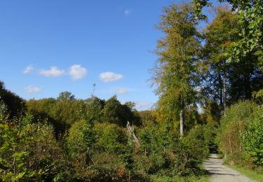
Magnifique forêt de Soignes !